Sold2023De Wit Map of Zeeland, HollandDE WIT, Frederick (c. 1630-1706). Comitatus Zelandiae tabula... Engraved map with original hand color. Amsterdam, c. 1680. 21 1/2" x 24 3/8" sheet, approx. Antique Map of Zeeland, Netherlands showingSee Sold Price
Sold2017de Wit: Antique Map of Portugal & Parts of Spain, 1690Title/Content of Map: 1690 de Wit Map of Portugal and Parts of Spain -- Tabula Portugalliae et Algarbia Date Printed: 1690, Amsterdam Cartographer: F de Wit Size: 18.5 x 22.2 in. Condition: Good. ExceSee Sold Price
Sold2020De Wit Map of Africa ca. 1685Frederick de Wit (ca. 1630 – 1706), "Totius Africae Accuratissima Tabula," Amsterdam, ca. 1685. Hand colored map of Africa. African animals are included throughout the continent, and the decoraSee Sold Price
Sold2023[MAP] DE WIT, F. NOVA ORBIS TABULA IN LUCEM EDITAde Wit, Frederik. NOVA ORBIS TABULA, IN LUCEM EDITA. (Amsterdam: circa 1670s.) Beautiful map in exquisite full handcolouring, with elaborate corner scenes illustrating the four seasons and the Zodiac,See Sold Price
Sold2022De Wit, Map of North and South America, c. 1720Property of a Private Collector, Hilton Head Island, SC Description: Frederick De Wit (circa 1629-1706), Nova Orbis Tabula In Lucem Edita, A.F. De Wit, Amsterdam: Covens and Mortier, c. 1720, publSee Sold Price
Sold2017de Wit: Map of Southeast Asia, 1670Map: Tabula Indiae Orientalis Cartographer: Frederick De Wit Place & Date: Amsterdam / 1670 Size: 22 1/4" x 18 1/4" Condition: light overall age-toning A highly decorative and beautifully colored lateSee Sold Price
Sold2017De Wit Map of AfricaTotius Africa Accuratissima Tabula. Frederick de Wit (1629/1630-1706). Engraved map with original hand color. Amsterdam, c. 1660. 19 1/4 x 23 inches visible, 24 3/4 x 28 1/2 inches framedSee Sold Price
Sold2015Tabula Indiae Orientalis byFrederick de Wit Amsterdam, 1662, de Wit's attractive hand-colored map of Southeast Asia, engraved by Joannas Lhulier, this map served as a prototype for Speed's map of the East Indies, cartouche withSee Sold Price
Sold2022De Wit - Nova Orbis Tabula In Lucem Edita, MapFrederick De Wit (circa 1629-1706), Nova Orbis Tabula In Lucem Edita, A.F. De Wit, published by Covens and Mortier, Amsterdam, circa 1720, in two sheets, engraving on laid paper, double hemisphere vieSee Sold Price
Sold20211690 ANTIQUE MAP OF LIMBURG NETHERLANDS by Frederik de1690 ANTIQUE MAP OF LIMBURG NETHERLANDS TABULA DUCATUS LIMBURCH ET COMITATUS VALCKENBURCH IN LUCEM EDITA A.F.WIT Copper-plate engraved map printed on laid paper,hand colored, no text on the verso By FSee Sold Price
Sold20191662 deWit Map of Southeast Asia -- Tabula IndiaeReserve Reduced! Title/Content of Map: 1662 deWit Map of Southeast Asia -- Tabula Indiae Orientalis Date: 1662, Amsterdam Cartographer: F de Witt Size: 18 X 22.2 in. This is a outstanding larger map oSee Sold Price
Sold2017De Wit Portolan Sea Chart of EuropeTotius Europae Victoria... Frederic De Wit (1630-1706). Engraved map with original hand color. Amsterdam, 1675. 20 x 35 1/2 inches sheet, 27 1/2 x 43 inches framed. “The most striking and decorativeSee Sold Price
Sold2018Allard Engraved Map of Iberian PeninsulaCorona Portugalliae cum ei affinibus Regnis Hispanicis...Carel Allard (1648-c. 1709). Engraved map with fine original hand color in full. Amsterdam: Frederick De Wit, c. 1705. In 4 parts, 21 1/8 x 24See Sold Price
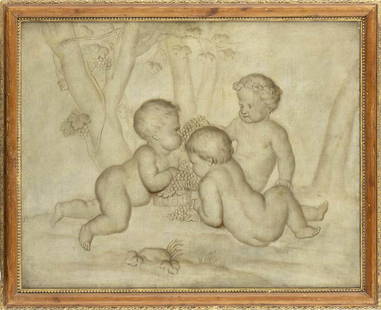
Sold2023JACOB DE WIT (Amsterdam, 1695-1754), ATTRIBUTED TOThree puttos with bunches of grapes Oil on canvas, cm. 65x82. FramedSee Sold Price
Sold2021Eleven Antique Maps of EuropeEleven Antique Maps of Europe , 16th-18th c., incl. Ptolemy from 1541 (4); a Blaeu map of "Regno di Napoli", Hondius map of the Holy Land, de Wit map of Southern Spain, an undated manuscript map of MeSee Sold Price
Sold2015Magnum Mare del Zur cum InsulaCalifornia by Frederick de Wit (1630-1706), Amsterdam, 1675, copper-engraved mariner's chart, hand-colored in outline, showing California as an island, Tooley #40, with a colorful pictorial cartoucheSee Sold Price
Sold2017WIT, Frederick de (1630-1706). [Composite Atlas].WIT, Frederick de (1630-1706). [Composite Atlas]. Amsterdam: F. de Wit, [n.d. ma circa 1680]. Bellissimo atlante composito con oltre 117 mappe di cui la maggior parte a doppia pagina e colorate all'epSee Sold Price
Sold2024EARLY 18TH C. DUTCH CHART OF PACIFIC OCEAN BY FREDERIK DE WIT (1629-1706) WITH CALIFORNIA AS AN"Magnuum Mare del Zur, cum Insula California, De Groote Zuyd-Zee en't Eylandt California; Gedruck't Amsterdam by Frederick De Wit ince Calver Street". Handcolored copper engraving. Engraver: Romeyn deSee Sold Price
Sold20181700 Pacific sea chart with Island of California andTitle: Mer de Sud ou Pacifique contenant l'Isle de Californe. Map maker: Pierre Mortier Place and Year: Amsterdam, 1700 Dimensions: 60 x 74.5 cm (23.6 x 29.3 in) Technique: Copperplate engraving ColorSee Sold Price
Sold2021Dutch Nicolaes Visscher I Map of New Amsterdam, ca 1690Nicolaes Visscher I. Map of Northeast with Early View of New York City. Ca. 1690 to 1729. A finely hand-colored example of Nicolaes Visscher I's illustrated map of the Northeast of America with an insSee Sold Price
Sold2016CARTE PARTICULIERE DE VIRGINIE, MARYLAND, PENNSYLVANIA;CARTE PARTICULIERE DE VIRGINIE, MARYLAND, PENNSYLVANIA; ALEXIS-HUBERT JAILLOT (1632-1712), ENGRAVED HAND COLORED MAP, AMSTERDAM AND PAIRIS, PIERRE MORTIER, C.1693-1710 (AN IMPORTANT CHART OF THE MID-ASee Sold Price
Sold2023BLAEU, Willem (1571-1638) -- BLAEU, Jan (1596-1673). Americae nova Tabula. [Amsterdam, ca 1635 orBLAEU, Willem (1571-1638) -- BLAEU, Jan (1596-1673). Americae nova Tabula. [Amsterdam, ca 1635 or later]. Engraved map of the Americas, visible area 17 x 21 3/4 in. (432 x 552 mm). Framed (unexaminedSee Sold Price
Sold2022Hondius, Map of Virginia, After John Smith, FramedHenry Hondius, after Capt. John Smith, "Nova Virginiae Tabula" (Amsterdam: 1639-'42) Engraving with hand coloring, 15 1/8 x 19 1/4 in., plus margins; in a birds-eye maple frameSee Sold Price
Sold2021Hondius. Nova Virginiae Tabula. 1633.[Virginia] Hondius, Henricus. "Nova Virginiae Tabula." Amsterdam, 1633. First impression with French text on verso, p 797, final catchword "peu", signature OOOOOOOO. Handcolored engraved map. DerivedSee Sold Price
7 hrs LeftTrillium Antique Prints & Rare BooksChatelain - 3 Engravings related to Madagascar and West Indies / Antilles Islands$75
7 hrs LeftTrillium Antique Prints & Rare BooksChatelain - Pair of Engravings related to Mexico City & Panama$75
8 hrs LeftHess Fine AuctionsGuillermo Gomez Gil (1862-1942) Signed Oil on Canvas Painting Flamenco Spanish Guitarist Painting$325(5 bids)
218 Lots AwayDutch Auction CompanyLot of 3 Vintage Fire Extinguishers - De Boer's Fabrieken Amsterdam€200
3 days LeftDOYLE Auctioneers & AppraisersTwo Dutch-Language Game of the Goose boards, one inspired by sorcery and the other by fairy tales$200
14 hrs LeftRiverfront Auctions"Arx Carolina" hand-colored engraving by Arnold Montanus c. 1671$100(1 bid)
3 days LeftDOYLE Auctioneers & AppraisersVictorian Architectural Inlaid Mahogany Tabletop Cabinet Inset with Numerous Cartes de Visite$750(1 bid)


![[MAP] DE WIT, F. NOVA ORBIS TABULA IN LUCEM EDITA: de Wit, Frederik. NOVA ORBIS TABULA, IN LUCEM EDITA. (Amsterdam: circa 1670s.) Beautiful map in exquisite full handcolouring, with elaborate corner scenes illustrating the four seasons and the Zodiac,](https://p1.liveauctioneers.com/8124/310027/165853624_1_x.jpg?height=310&quality=70&version=1700184289)


![WIT, Frederick de (1630-1706). [Composite Atlas].: WIT, Frederick de (1630-1706). [Composite Atlas]. Amsterdam: F. de Wit, [n.d. ma circa 1680]. Bellissimo atlante composito con oltre 117 mappe di cui la maggior parte a doppia pagina e colorate all'ep](https://p1.liveauctioneers.com/3662/102842/52581030_1_x.jpg?height=310&quality=70&version=1492593376)


![BLAEU, Willem (1571-1638) -- BLAEU, Jan (1596-1673). Americae nova Tabula. [Amsterdam, ca 1635 or: BLAEU, Willem (1571-1638) -- BLAEU, Jan (1596-1673). Americae nova Tabula. [Amsterdam, ca 1635 or later]. Engraved map of the Americas, visible area 17 x 21 3/4 in. (432 x 552 mm). Framed (unexamined](https://p1.liveauctioneers.com/197/305445/163194205_1_x.jpg?height=310&quality=70&version=1697056857)

![Hondius. Nova Virginiae Tabula. 1633.: [Virginia] Hondius, Henricus. "Nova Virginiae Tabula." Amsterdam, 1633. First impression with French text on verso, p 797, final catchword "peu", signature OOOOOOOO. Handcolored engraved map. Derived](https://p1.liveauctioneers.com/179/209052/106367556_1_x.jpg?height=310&quality=70&version=1624651037)


