Sold2022London.- Ogilby (John) The Continuation of the Road from London to Bristol; The Road from London toNO RESERVE London.- Ogilby (John) The Continuation of the Road from London to Bristol; The Road from London to St Davids, two road-strip maps, engravings with full hand-colouring, each approx. 340 x 4See Sold Price
Sold20221675 Ogilby Strip road Map of York to Scarborough -- The Roads from York to Whitby and ScarboroughTitle: 1675 Ogilby Strip road Map of York to Scarborough -- The Roads from York to Whitby and Scarborough in Yorkshi:… Cartographer: J Ogilby Year / Place: 1675, London Map Dimension (in.): 12.8See Sold Price
Sold2023Map: An 18thC engraved strip / road map after John Owen and Emanuel Bowen, showing the road fromMap: An 18thC engraved strip / road map after John Owen and Emanuel Bowen, showing the road from London to Rochester via Deptford, Crayford and Dartford. Approx. 7 1/4" x 4 3/4"See Sold Price
Sold2022British road maps.- Ogilby (John) The Roads fromNO RESERVE British road maps.- Ogilby (John) The Roads from Chelmsford in Essex to St. Edmonds-Bury in Suffolk & Saffron-Walden in Essex, strip road map, engraving with hand-colouring, on thin laid paSee Sold Price
Sold2021John Ogilby, circa 1698, The Road from London to St.John Ogilby, circa 1698, The Road from London to St. Davids in com. Pembroke, circa 1698, hand coloured engraved strip road map, sheet 14, 12" x 17.5", unframed.See Sold Price
Sold2021Strip maps for early California motoringHeading: (California) Author: Title: Collection of Strip Maps of California Roads and Highways, with Printed Map Index Place Published: Los Angeles Publisher:Automobile Club of Southern CaliforniaSee Sold Price
Sold20241645 Road Map by John Ogilby Buckingham to Bridgnorth Plate 23An antique road map showing the first accurate survey of the roads of England and Wales. This map shows the continuation of the extended road from Buckingham to Bridgnorth. 1 of over 100 maps publisheSee Sold Price
Sold2019Ogilby's road through Wales 1675Heading: (Maps) Author: Ogilby, John Title: The Road From St Davids com Pembroke to Holywell com Flint Place Published: Publisher: Date Published: Description: Copper-engrSee Sold Price
Sold2022Pair of English Map Plates, by Ogilby.Artist: John Ogilby. Title/Subject: "The Road from Hereford to Leicester"; and "The Continuation of the Road from Chester to Cardiff com. Glamorgan." Size: Each 15in x 19in; 16 3/4in x 20 1/2in (frameSee Sold Price
Sold2022After John OgilbyAfter John Ogilby After John Ogilby, 17th/18th century, 'The Continuation of the Road from London to Barwick', engraved and hand coloured road map, framed, 33 x 45.5cm Condition Report: Some visible cSee Sold Price
Sold2016J Basire: Plan of Toulon 1740Map: Plan of Toulon, With a View of Its Road, and the Situation Of Its Towns Maker: J Basire Publishing: Tindal: Boston Date: 1740 Size: 14 x 18 inches From Tindal's continuation of Rapin de Thoyros'See Sold Price
Sold20211930s Southern California Map -- Road Map SouthernTitle: 1930s Southern California Map -- Road Map Southern section of California Cartographer: Automobile Club of Southern California Year / Place: mid 1930s, Los Angeles Map Dimension (in.): 16.8 X 31See Sold Price
Sold2024Original Engraving Map - Continuation of the Map of Hindustan - India - Asia - Nicolas BellinIts finely engraved, hand-coloring engraved map from the Dutch edition of acques Nicolas Bellin Histoire General des Voyages. Published in Amsterdam, 1770 year. Map of the island of Cayenne and surrouSee Sold Price
Sold202318th Century English Double-Sided Strip MapFrame measures 15 x 12 inches, Map measures 8 x 5 inches.See Sold Price
Sold2018MAPS: Roads of England and Wales c1860 color mapMAPS: Roads of England and Wales c1860 color map, The Roads of England and Wales, with the whole of Scotland, showing the Distances between each Town, and from London; also the tracks of the Steam NavSee Sold Price
Sold2021(NEW YORK.) David H. Burr. Hudson River & Vicinity.(NEW YORK.) David H. Burr. Hudson River & Vicinity. Engraved strip map of the Hudson River from lower Warren County to New York City. 24¾x4½ inches extended, folding into publisher's 12mo foSee Sold Price
Sold2020Road Map of New MexicoTitle/Content of Map: Road Map of New Mexico Date: 1936 Cartographer: GOUSHA, H. M. CO. Publisher: STANDARD OIL COMPANY OF TEXAS Size: 23Height - 17Width Full color road map. Entire US on reverse. CovSee Sold Price
Sold2021Large Group of Vintage Maps,Road Atlas - Atlas of theLarge Group of Vintage Maps,Road Atlas - Atlas of the World War, Atlas Portfolio w/ Asst Loose Maps, Maps from Around The WorldSee Sold Price
Sold2022VINTAGE NORTH EASTERN US & FRENCH ROAD MAPSVINTAGE NORTH EASTERN US & FRENCH ROAD MAPS Road maps of the eastern seaboard of PA, NY, D.C., VA, MD, and NJ by AAA and Exxon. Also included are five Michelin maps of France.See Sold Price
Sold2024Keith Haring Artwork Signed on a Shell Oil New York Road Map 18 in. x 24 in.Keith Haring Artwork Signed on a Shell Oil New York Road Map 18 in. x 24 in. size: 18 x 42 open - rippingSee Sold Price
Sold2022HUSKY GASOLINE SERVICE STATION MAP DISPLAY W/ HUSKY ROAD MAPS.SST. An excellent and complete example of this Circa 1950's Service Station Road Map Display from Husky showing a Tin Husky Sign at the face and complete with Maps. CONDITION: Display is in overall exSee Sold Price
Sold2022New road map of the city of Paris 1839 Rosselin editeur engravingNouveau plan routier de la ville de Paris, Guide exacte de cette capitale : en 12 arrondissemens avec leurs mairies et en 48 quartiers, 1839V. ROSSELIN (19th century), print editor, Paris, EstablishedSee Sold Price
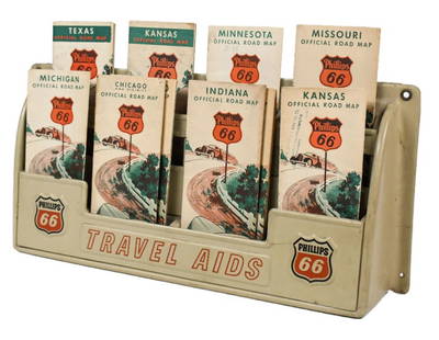
Sold2023Vintage Phillips 66 Road Map Embossed Display RackVintage Phillips 66 embossed plastic road map display rack full with original 1930s Phillips 66 maps. Rack has discoloration, some expected chips/ cracks, and wear from use and age. Displays well withSee Sold Price
May 17Albion AuctionsPaterson & Mogg C1830 British Road Map. Cumberland, Westmorland & Lancashire$5(1 bid)
May 17Albion AuctionsPaterson & Mogg C1830 British Road Map. Isle of Thanet and Adjacent Country$5(1 bid)
May 17Albion AuctionsPaterson & Mogg C1830 British Road Map. New Shorehamd to Chichester to Fareham$5(1 bid)
May 17Albion AuctionsPaterson & Mogg C1830 British Road Map. Banks of the River Wye. Chepstow etc$5(1 bid)
May 17Ni-Cola Classics - Automobilia Auction & Classic Car SalesAutomobilia Road map 'Inverno-Primavera 1937-XV'€50