Sold2019Isaak Tirion (1705-1765, Dutch), "Grondvlakte van NieuwIsaak Tirion (1705-1765, Dutch), "Grondvlakte van Nieuw Orleans, de Hoofdstad van Louisiana (Ground Plan of New Orleans, of the Capital of Louisiana)...", Â 1769, hand-colored engraved map, H.- 15 iSee Sold Price
Sold2017MAP, C. 1750, INDIA & SOUTHEAST ASIA, ISAAK TIRIONFramed map of India an nearby countries, "Nieuwe Kaart van India over de Ganges of van Malakka, Siam, Cambodia, Chiampa, Kochinchina, Laos, Pegu, Ava" c. 1750 by Issak Tirion (Dutch, 1705-1765), handSee Sold Price
Sold2023MAP, Malta, TirionMalta. Isaac Tirion, Nieuwe Kaart van't Eiland Maltha met Gozo en Comino..., from Nieuwe en Beknopte Hand Atlas, 1761 (dated). Hand Color. Handsome, large map of the Maltese Islands with superb detailSee Sold Price
Sold2016Map, Isaak Tirion, Nieuwe Kaart Van EuropaIsaak Tirion (Dutch, 1705-1765), "Nieuwe Kaart Van Europa," hand-colored copper engraving, overall (with frame): 19"h x 21"wSee Sold Price
Sold2019Isaak Tirion (1705-1765, Amsterdam), "Nieuwe Kaart vanIsaak Tirion (1705-1765, Amsterdam), "Nieuwe Kaart van America," 1766, hand colored, H. - 12 in., W. - 13 in.See Sold Price
Sold2019Isaak Tirion (1705-1765), "Kaart van hel WestelykIsaak Tirion (1705-1765), "Kaart van hel Westelyk Gedeelte van Nieuw Mexico en van California," 1765, hand colored, H.- 15 in., W.- 19 in.See Sold Price
Sold2019Isaak Tirion (1705-1765, Amsterdam), "Nieuwe Kaart vanIsaak Tirion (1705-1765, Amsterdam), "Nieuwe Kaart van Arabia,"18th c., hand colored, H. - 15 in., W. - 18 in.See Sold Price
Sold2019Isaak Tirion (1705-1765, Amsterdam), "Nieuwe Kaart vantIsaak Tirion (1705-1765, Amsterdam), "Nieuwe Kaart vant Eilan Ceilon," hand colored, H. - 16 in., W. - 21 in.See Sold Price
Sold2019Isaak Tirion (1705-1765, Amsterdam), "Nieuwe Kaart vanIsaak Tirion (1705-1765, Amsterdam), "Nieuwe Kaart van het Zuidelykste Gedeltevan Frankryk," 1757, hand colored, H. - 16 7/8 in., W. - 20 7/8 in.See Sold Price
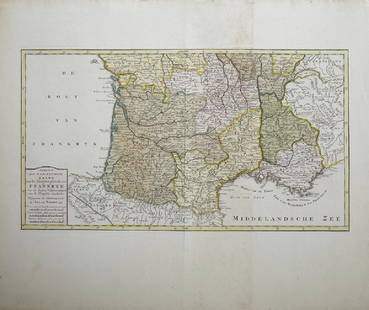
Sold2019Isaak Tirion (1705-1765, Amsterdam), "Nieuwe Kaart vanIsaak Tirion (1705-1765, Amsterdam), "Nieuwe Kaart van Frankryk," hand colored, H. - 17 in., W. -20 1/2 in.See Sold Price
Sold20191760 Hand Colored Map of Panama TirionFine engraved handcolored map of Panama entitled “Kaart van de Landengte van Panama”, by Isaak Tirion at Amsterdam circa 1760. Measures 17 x 16”. Reserve: $20.00 Shipping: Domestic: Flat-rate ofSee Sold Price
Sold20191766 Beautiful Handcolored Map Cayenne1766 hand colored engraved map and plan “Land-Kaart van het Eiland en de Volkplanting van Cayenne aus de Kust van Zuid-Amerika”, by Isaak Tirion,. Fine, close right margin. Measures 18 x 16”, foSee Sold Price
Sold2016Caert vernieuwd geamplieerd en gecorrigeerd. Tirion.Anno 1746 is dese Caert vernieuwd geamplieerd en gecorrigeerd Maker: Tirion, Isaak. Origin: Amsterdam, 1746. Medium: Original copper engraving with later hand-coloring. Sheet size: 19 3/4 x 25 1/4 in.See Sold Price
2018Tirion: Antique Map of North Pole & Northern RegionsTitle/Content of Map: North Pole & Northern Regions by Tirion Date Printed: 1735-1740 Cartographer: Isaak Tirion Material/Medium: Paper Size: 13" x 13" Hand colored. Copperplate engraved. Published inSee Sold Price
Sold2018Reis En Hand Atlas, 1703van Vlaanderen, Braband en Aanleggende Landschappen, Amsterdam: S. J. Baalde, 1703, 38 double-page hand-colored maps, bound in paper boards with leather spine, maps are by Jean de Lat and Jacob KeizerSee Sold Price
Sold2021StielerÃs Hand Atlas 5th Ed. 1872 [129903]Formally titled Hand-atlas [x=#252/]ber alle Theile der Erde und [x=#252/]ber das Weltgeb[x=#228/]ude ( Handy atlas of all parts of the world and universe). Considered the leading German world atlas aSee Sold Price
Sold2019Stieler's Hand-Atlas 1905Heading: Author: Perthes, Justus Title: Stieler's Hand-Atlas. 100 Karten in kupfersticht mit 162 nebenkarten Place Published: Gotha Publisher:Justus Perthes Date Published: 1905 DescriSee Sold Price
Sold20171882 Historical Hand Atlas, H. H. Hardesty Map1882 Historical Hand Atlas Illustrated, H. H. Hardesty 11.5 X 15. This Hard-to-find Atlas Has Been Rebound—it Will Look Great on Your Shelf. Several State Maps (texas/indian Territory, California/laSee Sold Price
Sold2019Two Maps by Isaak Tirion (1705-1765, Amsterdam),Two Maps by Isaak Tirion (1705-1765, Amsterdam), "Nieuwe Kaart Va restelykste Deel Der Weereld..Scheepstogten der Nederlanderen Naar Westindie," 1754, H. - 14 in., W. - 15 in., and H.- 17 in., W.- 20See Sold Price
Sold2020Isaak Tirion after J.C Philips: CherubimIsaak Tirion after J.C Philips: Cherubim , engraving, 1745, framed, with identifying information in Dutch verso. 4 1/2 x 7" paper, 10 1/2 x 13 3/5" frameSee Sold Price
Sold2021STIELERS HANDATLAS GERMAN MAP OF SOUTH AMERICAFramed engraving with hand coloring on paper, German map of South America, single sheet, from "Stielers Hand-Atlas," c.1878, Johann Friedrich von Stulpnagel (1786-1865) cartographer, published by JustSee Sold Price
Sold20241881 Historical Illustrated General and Local Hand AtlasPublisher - H.H. Hardesty & Co., Monroe County Michigan, Binding loose, Front cover not fully attached, Measures 15 x 11 1/4 x 1 3/4 inches.See Sold Price
2020Isaak Tirion Print of European MapPrint on paper, framed. Featuring "map of nations". 29 x 37 cm (11.25 x 14.25 in), Frame: 34 x 42 cm (13.25 x 16.5 in). PROVENANCE: This lot carries limited provenance from a Private German collectionSee Sold Price
Sold2022Hand Atlas of Human Anatomy3 Volume Set. Spalteholz. Allard Auction Collection Inv: GADSee Sold Price
5 days LeftDOYLE Auctioneers & AppraisersAn attractive eighteenth-century Dutch map of the Americas$150
Jul 09Hermann Historica GmbHOskar Messter - a hand atlas as the head of the aerial photos test department in Adlershof€200
3 days LeftRapid Estate Liquidators and Auction GalleryVintage Hand Painted Resin Atlas & Heracles Holding The Heavens$625
Featured5 days LeftJasper52Amér Sep Grandes Antilles 73 Jamaica Pedro Bank San Andrés VANDERMAELEN 1827 map$45
5 days LeftJasper52Amér. Mér. Guyane Anglaise #4 bis. Guyana Suriname. VANDERMAELEN 1827 old map$35
5 days LeftJasper52Amér Sep Porto Rico #69 Puerto Rico & Virgin Islands VANDERMAELEN 1827 old map$140
5 days LeftJasper52Amér. Sep. Curacao #74. Aruba Bonaire Puerto Rico Beata. VANDERMAELEN 1827 map$140
5 days LeftJasper52Amér. Sep. Ile de Cuba #67. Cuba & Jamaica Cayman Islands. VANDERMAELEN 1827 map$160
Featured5 days LeftJasper52Johnson's West Indies. Bermuda Islands. Caribbean Bahamas Antilles 1866 map$120
BonhamsCARSWELL, ROBERT. 1793-1857. Pathological Anatomy. Illustrations of the Elementary Forms of Dise...$2,400(1 bid)
5 days LeftJasper52Windward or South Caribbean Islands. Barbados St. Lucia Trinidad. LOWRY 1860 map$55(1 bid)
5 days LeftJasper52Grenada, Tobago, Trinidad & Curaçao. West Indies Caribbean. THOMSON 1817 map$85
5 days LeftJasper52Leeward Islands. Cuba, Hayti/Haiti or Santo Domingo, Puerto Rico. LOWRY 1859 map$110
Featured5 days LeftJasper52British West Indies. Virgin Leeward Windward Islands. Bermuda. SWANSTON 1860 map$120
5 days LeftJasper52Puerto Rico & Virgin Islands. Haiti, Hispaniola or St. Domingo. THOMSON 1817 map$140
5 days LeftJasper52Puerto Rico & Virgin Islands. Haiti, Hispaniola or St. Domingo. THOMSON 1817 map$140
Featured5 days LeftJasper52British, Dutch & French Guiana. Suriname Guyana. LOWRY 1860 old antique map$30
5 days LeftJasper52Windward or South Caribbean Islands. Barbados St. Lucia. Guianas. LOWRY 1859 map$60
Featured5 days LeftJasper52Grenada, Tobago, Trinidad & Curaçao. West Indies Caribbean. THOMSON 1830 map$85
5 days LeftJasper52Grenada, Tobago, Trinidad & Curaçao. West Indies Caribbean. THOMSON 1817 map$100


![StielerÃs Hand Atlas 5th Ed. 1872 [129903]: Formally titled Hand-atlas [x=#252/]ber alle Theile der Erde und [x=#252/]ber das Weltgeb[x=#228/]ude ( Handy atlas of all parts of the world and universe). Considered the leading German world atlas a](https://p1.liveauctioneers.com/2699/202326/102449348_1_x.jpg?height=310&quality=70&version=1619652794)


