Sold2019Two Maps by Isaak Tirion (1705-1765, Amsterdam),Two Maps by Isaak Tirion (1705-1765, Amsterdam), "Nieuwe Kaart Va restelykste Deel Der Weereld..Scheepstogten der Nederlanderen Naar Westindie," 1754, H. - 14 in., W. - 15 in., and H.- 17 in., W.- 20See Sold Price
Sold2019Isaak Tirion (1705-1765, Amsterdam), "Nieuwe Kaart vanIsaak Tirion (1705-1765, Amsterdam), "Nieuwe Kaart van America," 1766, hand colored, H. - 12 in., W. - 13 in.See Sold Price
Sold2019Isaak Tirion (1705-1765, Amsterdam), "Nieuwe Kaart vanIsaak Tirion (1705-1765, Amsterdam), "Nieuwe Kaart van Arabia,"18th c., hand colored, H. - 15 in., W. - 18 in.See Sold Price
Sold2019Isaak Tirion (1705-1765, Amsterdam), "Nieuwe Kaart vantIsaak Tirion (1705-1765, Amsterdam), "Nieuwe Kaart vant Eilan Ceilon," hand colored, H. - 16 in., W. - 21 in.See Sold Price
Sold2019Isaak Tirion (1705-1765, Amsterdam), "Nieuwe Kaart vanIsaak Tirion (1705-1765, Amsterdam), "Nieuwe Kaart van het Zuidelykste Gedeltevan Frankryk," 1757, hand colored, H. - 16 7/8 in., W. - 20 7/8 in.See Sold Price
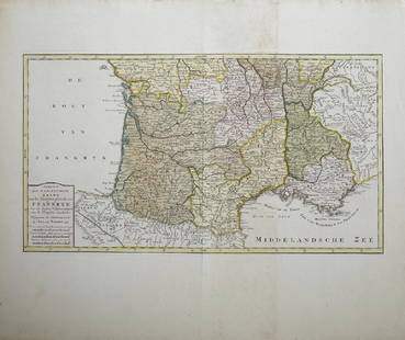
Sold2019Isaak Tirion (1705-1765, Amsterdam), "Nieuwe Kaart vanIsaak Tirion (1705-1765, Amsterdam), "Nieuwe Kaart van Frankryk," hand colored, H. - 17 in., W. -20 1/2 in.See Sold Price
Sold2016Map, Isaak Tirion, Nieuwe Kaart Van EuropaIsaak Tirion (Dutch, 1705-1765), "Nieuwe Kaart Van Europa," hand-colored copper engraving, overall (with frame): 19"h x 21"wSee Sold Price
Sold2019Isaak Tirion (1705-1765, Dutch), "Grondvlakte van NieuwIsaak Tirion (1705-1765, Dutch), "Grondvlakte van Nieuw Orleans, de Hoofdstad van Louisiana (Ground Plan of New Orleans, of the Capital of Louisiana)...", Â 1769, hand-colored engraved map, H.- 15 iSee Sold Price
Sold2017MAP, C. 1750, INDIA & SOUTHEAST ASIA, ISAAK TIRIONFramed map of India an nearby countries, "Nieuwe Kaart van India over de Ganges of van Malakka, Siam, Cambodia, Chiampa, Kochinchina, Laos, Pegu, Ava" c. 1750 by Issak Tirion (Dutch, 1705-1765), handSee Sold Price
Sold2019Isaak Tirion (1705-1765), "Kaart van hel WestelykIsaak Tirion (1705-1765), "Kaart van hel Westelyk Gedeelte van Nieuw Mexico en van California," 1765, hand colored, H.- 15 in., W.- 19 in.See Sold Price
Sold2019Attributed to Isaak Tirion (1705-1765), "Kaart Van HetAttributed to Isaak Tirion (1705-1765), "Kaart Van Het Eiland Terre-Nueve, Van Nieuw Schotland/Kanada," c. 1740, engraving on laid paper, H. - 9 in., W. - 13.5 in.See Sold Price
Sold20191760 Hand Colored Map of Panama TirionFine engraved handcolored map of Panama entitled “Kaart van de Landengte van Panama”, by Isaak Tirion at Amsterdam circa 1760. Measures 17 x 16”. Reserve: $20.00 Shipping: Domestic: Flat-rate ofSee Sold Price
Sold2016Caert vernieuwd geamplieerd en gecorrigeerd. Tirion.Anno 1746 is dese Caert vernieuwd geamplieerd en gecorrigeerd Maker: Tirion, Isaak. Origin: Amsterdam, 1746. Medium: Original copper engraving with later hand-coloring. Sheet size: 19 3/4 x 25 1/4 in.See Sold Price
2020Isaak Tirion Print of European MapPrint on paper, framed. Featuring "map of nations". 29 x 37 cm (11.25 x 14.25 in), Frame: 34 x 42 cm (13.25 x 16.5 in). PROVENANCE: This lot carries limited provenance from a Private German collectionSee Sold Price
Sold2019Two Maps by Willem Janszoon Blaeu (1571-1638,Two Maps by Willem Janszoon Blaeu (1571-1638, Amsterdam), "Noramndia Ducatus (with History on reverse)," 1640; together with "Languedoc," 1640, hand colored, Languedoc- H. - 19 in., W. 24 in., DucatusSee Sold Price
Sold2019Two Maps by Willem Janszoon Blaeu (1571-1638,Two Maps by Willem Janszoon Blaeu (1571-1638, Amsterdam), "Burgundia Ducatus," 1640; together with "Champagne Latine Campania Comitatus," 1640, hand colored, Champagne- H. - 16 in., W. - 23 in., BurguSee Sold Price
Sold2022Ortelius and Hondius - Two Maps, Florida and Caribbeanincluding: Abraham Ortelius (1527-1598), La Florida/Guastecan/Peruviae Auriferae Regionis Typus, Amsterdam, circa 1584-1609, text verso, in two sheets, engraving on laid paper with hand colored highliSee Sold Price
Sold2020History of England with 4 maps, 1765Heading: (England) Author: Title: The Geography and History of England: Done in the manner of Gordon's and Salmon's geographical and historical grammars. In two parts... Place Published: London PubliSee Sold Price
Sold2019With two maps featuring California as an island, 1752Heading: (California as an Island) Author: de Chevigni; de Limiers; Massuet, Pierre Title: La Science Des Personnes De Cour, D'Epe?e Et De Robe. Place Published: Amsterdam Publisher:Z. Chatelain & FilSee Sold Price
Sold2024Two Maps of AlsaceAmsterdam, Pierre Vander, ca. 1713. Matted map, small, of L’ Alsace with new observations of the royal academie, with some hand coloring. Sheet size apprx 9-3/4" x 12", overall with mat apprSee Sold Price
Sold2017Chatelain: Double Hemisphere Antique World Map, 1705Map: Mappemonde ou Description General du Globe Terrestre Cartographer: Henri Chatelain Place & Date: Amsterdam / 1705 Size: 17 1/4" x 13 1/4" Condition: wash color; overall age toning, repaired splitSee Sold Price
Sold20191766 Beautiful Handcolored Map Cayenne1766 hand colored engraved map and plan “Land-Kaart van het Eiland en de Volkplanting van Cayenne aus de Kust van Zuid-Amerika”, by Isaak Tirion,. Fine, close right margin. Measures 18 x 16”, foSee Sold Price
Sold20202 Maps of Sardinia and Corsica Mercator and HondiGroup of two maps of Sardinia and Corsica. Gerardus Mercator (1512–1594) and Jodocus Hondius (1563–1612), a hand colored map of Sardinia and Corsica, Amsterdam, 1607. From Atlas Minor GeSee Sold Price
Sold2022Two Early Maps and Framed Currency of German InterestTwo Early Maps and Framed Currency of German Interestto include: Blaeu, Willem. Terretorium Abbatiae Heresfeldensis (Amsterdam, 1660s), with Spanish text en verso, presented in two-sided gilt wooden fSee Sold Price
May 28Carlo Bonte AuctionsAttrib. to Charles Van Loo (1705-1765), portrait of Louis Joseph de Bourbon, Prince of Conde in€6,000
5 days LeftJasper521943 Denver & Rio Grande Western Railroad Map in Rocky Mountain Views Brouchure -- Rocky Mountain$40
May 14Akiba Galleries(2 Pc) Allain Manesson Mallet Description De L'Univers 2 Vol. German Translation$200(1 bid)
May 12Schilb Antiquarian Rare Books1881 Westchester County New York Yonkers Illustrated MAPS 2v SET Bolton History$26(3 bids)
7 days LeftHunt and Peck Estate Services, Inc.Covens & Mortier Map Of The Duchy Of Mantua In Amsterdam$70
7 days LeftHunt and Peck Estate Services, Inc.Two 1st Edition Books Theodore Dreiser 1912"The Financier" and 1911 "Jennie Gerhardt"$100
7 days LeftHunt and Peck Estate Services, Inc.G. De L'Isle/Covens & Mortier Map Of Congo And The Country Of The Cafres$140
May 16Ma San AuctionTHREE ANTIQUARIAN MAPS ON CHINA. 'The Great Imperial Throne from Le Comte', Beijing. G. CHILD£50