Sold2016Danemark, Suede, & Norwege by Guillaume De L'Isle 1730Map Title: Carte des Courones du Nord Qui Comprend les Royaumes de Danemark, Suede, & Norwege, &c. Artist: Guillaume De L'Isle Publisher: Jean Covens and Corneille Mortier, Amsterdam Date: 1730 Size:See Sold Price
Sold2021Early Map of Greece and EnvironsEarly and Rare map by Jean Covens and Corneille Mortier of Greece, the Aegean, Asia Minor and the lower Balkans. 19 ½ x 26 inches (approximately)See Sold Price
Sold2024G. De L'Isle/Covens & Mortier Map Of Congo And The Country Of The CafresBy G. De L'Isle of the royal of acedemy sciences, in Amsterdam at Jean Covens and Corneille Mortier geographersSee Sold Price
Sold2024Covens & Mortier Map Of The Duchy Of Mantua In AmsterdamMap Of The Course Of The Po In The Duchy Of Mantua in Amsterdam By Jean Covens and Corneille Mortier, hand coloredSee Sold Price
Sold2024G. De L'Isle/Covens & Mortier Map Of Egypt, Nubia, And AbissiniaBy G. De L'Isle of the royal of acedemy sciences, in Amsterdam at Jean Covens and Corneille Mortier geographersSee Sold Price
Sold2019Charles Jean Covens & Corneille Mortier (1721-1766,Charles Jean Covens & Corneille Mortier (1721-1766, Amsterdam), "Carte General de la Caroline," 1700, hand colored, H. - 24 3/8 in., W. -20 5/8 in.See Sold Price
Sold2019Charles Jean Covens & Corneille Mortier (1721-1766,Charles Jean Covens & Corneille Mortier (1721-1766, Amsterdam), "Carte Generale de Toutes les Costes du Monde et les Pays Nouvellement decouvert dresse sur les Relations," 1718, hand colored, H. - 24See Sold Price
Sold20201730 Covens & Mortier Map of Poland, Lithuania, LatviaTitle: 1730 Covens & Mortier Map of Poland, Lithuania, Latvia to Moscow -- Tabula Regni Poloniae Ducatus Lithuaniae &c. / La Pologne Dressee sur ce qu'en ont donne Starovolsk, Beauplan, Hartnoch, et aSee Sold Price
Sold20221730 Covens & Mortier Map of Parts of Coastal Brazil --Title: 1730 Covens & Mortier Map of Parts of Coastal Brazil -- Preafectura De Ciriii, vel Seregippe Delrey cum Itapuama Cartographer: Covens & Mortier Year / Place: 1730 c., Amstredam Map Dimension (iSee Sold Price
Sold2019* DELISLE, Guillaume (1675-1726). Hemisphere* DELISLE, Guillaume (1675-1726). Hemisphere Septentrional pour voir Plus Distinctoment les Terres Arctiques. [Paris:] Covens and Mortier, ca 1730. Engraved map of the Northern Hemisphere, image 462 xSee Sold Price
Sold2019* DELISLE, Guillaume (1675-1726). Hemisphere Occidental* DELISLE, Guillaume (1675-1726). Hemisphere Occidental Dressee en 1720 pour l'usage particulier du Roy. [Paris:] Covens and Mortier, ca 1730. Engraved map of the Western Hemisphere, image 480 x 475 (See Sold Price
Sold2018Sanson/Covens & Mortier: Eastern Holy Land, 1730The later Covens & Mortier edition of Sanson's map of the eastern part of the land of Canaan "now Palestine," derived from von Adrichom's Holy Land map (Situs Terrae Promissionis). Oriented with the wSee Sold Price
Sold2018Sanson: North Africa / Patriarchate of Alexandria, 1730Partriarchatus Alexandrini Geographica descriptio The later Covens & Mortier edition of Sanson's map of the Patriarchate of Alexandria encompassing Libya and Egypt, with great detail and many place naSee Sold Price
Sold2016D'Anville map of the Americas 1774Heading: Author: d'Anville, Jean Baptiste Bourguignon Title: Carte d'Amerique Divisees en ses Principales Parties, par G. Delisle... Place Published: Amsterdam Publisher:Covens & Mortier Date PuSee Sold Price
Sold2020Covens & Mortier Map of the World ca. 1700 CalifoJohannes Covens (1697-1774) and Cornelius Mortier (1699-1783), "Carte Generale du Monde, ou Description du Monde Terrestre & Aquatique," Amsterdam, ca. 1700. This map of the world shows California asSee Sold Price
Sold20201740 Covens & Mortier Map of Biblical Middle East --Title: 1740 Covens & Mortier Map of Biblical Middle East -- Carte de la Situation du Paradis Terrestre, Et des Pais Habitez par les Patriarches Dressee pour bien entendre l'Histoire Sainte, Par MessirSee Sold Price
Sold20191740 Covens & Mortier Map of Northern Russia in EuropeTitle: 1740 Covens & Mortier Map of Northern Russia in Europe -- Carte de Moscovie Dressee par Guillaume de l'Isle de l'Academie Royale des Sciences a son Excellence Monseigneur Andre Artemonides de MSee Sold Price
Sold2021Delisle, Covens & Mortier 1739 Map of FranceMap of Narbonne, France engraved by Delisle/Covens & Mortier depicting churches, parishes, abbeys, roads, and villages. Also included is an inset plan of the fortified city with index table. ConservatSee Sold Price
Sold2023Carel Allard, Map of England & Wales, 18th CenturyDescription: A ca. 1740 map of England (Regni Angliae Wallae Principatus Tabula) by Carel Allard, published by Covens & Mortier. Type: Map Materials: Paper Markings & Inscriptions: Marked Date: Ca. 17See Sold Price
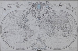
Sold20181745 Covens and Mortier World Map -- Mappe-MondeTitle/Content of Map: 1745 Covens and Mortier World Map -- Mappe-Monde Dressee sur les Observations de Mrs. de l'Academie Royale des Sciences et Quelques Autres et sur les Memoires les Plus Recens DatSee Sold Price
20181745 Covens and Mortier World Map -- Mappe-MondeTitle/Content of Map: 1745 Covens and Mortier World Map -- Mappe-Monde Dressee sur les Observations de Mrs. de l'Academie Royale des Sciences et Quelques Autres et sur les Memoires les Plus Recens DatSee Sold Price
Sold2021Le Clerc, Jean 1730 Map. Antwerp, Belgium. Ships"Het belegh der Stadt Antwerpen in den Taeren" Copper Engraved Map Published 1730, Amsterdam for "Geschiedenissen der vereenigde Nederlanden" by Jean Le Clerc. Centre fold as published. Paper Size: 16See Sold Price
Sold2021Le Clerc, Jean 1730 Map. Groningen, NetherlandsCopper Engraved Map Published 1730, Amsterdam for "Geschiedenissen der vereenigde Nederlanden" by Jean Le Clerc. Centre fold as published. Paper Size: 16 x 13.5 inch (42 x 34cm) Good ConditionSee Sold Price
5 days LeftJasper521730 Covens & Mortier Map of North Coast of Africa and Southern Europe -- In Notitiam Ecclesiasticam$80
5 days LeftJasper521730 Seutter Map of Northwest France -- Artesia cum Finitimis Locis Velut Sedes ac Theatrum Belli$110
2 days LeftFichter KunsthandelM. SEUTTER (1678-1756), Dresden city map and panoramic view, 1730, Copper engraving€500
May 30Forum Auctionsd'Anville (Jean Baptiste Bourguignon) [Untitled Composite Atlas with 102 map sheets], [probably£2,000


![* DELISLE, Guillaume (1675-1726). Hemisphere: * DELISLE, Guillaume (1675-1726). Hemisphere Septentrional pour voir Plus Distinctoment les Terres Arctiques. [Paris:] Covens and Mortier, ca 1730. Engraved map of the Northern Hemisphere, image 462 x](https://p1.liveauctioneers.com/197/138502/70223753_1_x.jpg?height=310&quality=70&version=1553021482)
![* DELISLE, Guillaume (1675-1726). Hemisphere Occidental: * DELISLE, Guillaume (1675-1726). Hemisphere Occidental Dressee en 1720 pour l'usage particulier du Roy. [Paris:] Covens and Mortier, ca 1730. Engraved map of the Western Hemisphere, image 480 x 475 (](https://p1.liveauctioneers.com/197/138502/70223752_1_x.jpg?height=310&quality=70&version=1553021482)


![[MAPS]. A group of 3 engraved maps, most with hand-coloring. (1 of 4)](https://p1.liveauctioneers.com/197/328642/177014805_1_x.jpg?height=282&quality=70&version=1714760103)
![d'Anville (Jean Baptiste Bourguignon) [Untitled Composite Atlas with 102 map sheets], [probably (1 of 3)](https://p1.liveauctioneers.com/5458/329231/177514974_1_x.jpg?height=282&quality=70&version=1715269091)


