Sold20221730 Covens & Mortier Map of Parts of Coastal Brazil --Title: 1730 Covens & Mortier Map of Parts of Coastal Brazil -- Preafectura De Ciriii, vel Seregippe Delrey cum Itapuama Cartographer: Covens & Mortier Year / Place: 1730 c., Amstredam Map Dimension (iSee Sold Price
Sold2018Sanson/Covens & Mortier: Eastern Holy Land, 1730The later Covens & Mortier edition of Sanson's map of the eastern part of the land of Canaan "now Palestine," derived from von Adrichom's Holy Land map (Situs Terrae Promissionis). Oriented with the wSee Sold Price
Sold20201730 Covens & Mortier Map of Poland, Lithuania, LatviaTitle: 1730 Covens & Mortier Map of Poland, Lithuania, Latvia to Moscow -- Tabula Regni Poloniae Ducatus Lithuaniae &c. / La Pologne Dressee sur ce qu'en ont donne Starovolsk, Beauplan, Hartnoch, et aSee Sold Price
Sold20223 framed Mortier 18th cent maps of Coastal SpainCovens & Mortier, circa 1737, Amsterdam, 3 framed maps of Coastal Spain, Coste D'Espagne, Plan du Port de Cartagene, and Coste de Catalogne, hand colored engravings, 18.5 x 26.5 inches image size, fraSee Sold Price
Sold2019* DELISLE, Guillaume (1675-1726). Hemisphere* DELISLE, Guillaume (1675-1726). Hemisphere Septentrional pour voir Plus Distinctoment les Terres Arctiques. [Paris:] Covens and Mortier, ca 1730. Engraved map of the Northern Hemisphere, image 462 xSee Sold Price
Sold2019* DELISLE, Guillaume (1675-1726). Hemisphere Occidental* DELISLE, Guillaume (1675-1726). Hemisphere Occidental Dressee en 1720 pour l'usage particulier du Roy. [Paris:] Covens and Mortier, ca 1730. Engraved map of the Western Hemisphere, image 480 x 475 (See Sold Price
Sold2018Sanson: North Africa / Patriarchate of Alexandria, 1730Partriarchatus Alexandrini Geographica descriptio The later Covens & Mortier edition of Sanson's map of the Patriarchate of Alexandria encompassing Libya and Egypt, with great detail and many place naSee Sold Price
Sold2016Map of Milan, c. 1720Le Duché de Milan dans toute son estendue... Cornelis Mortier (1699-1783) & Johannes Covens I (1697-1774). Engraved map with original hand color in part. Amsterdam: Covens & Mortier, c. 1720. 24 1/2See Sold Price
Sold2016Danemark, Suede, & Norwege by Guillaume De L'Isle 1730Map Title: Carte des Courones du Nord Qui Comprend les Royaumes de Danemark, Suede, & Norwege, &c. Artist: Guillaume De L'Isle Publisher: Jean Covens and Corneille Mortier, Amsterdam Date: 1730 Size:See Sold Price
Sold2018SDUK: Antique Map of Bolivia & Peru, 1846TITLE/CONTENT OF MAP: 'SOUTH AMERICA, SHEET VI., BOLIVIA AND PERU WITH A PART OF BRAZIL' Bolivia Litoral / sea coast. The map shows Bolivia with its Litoral (coastal) province, which it lost in the laSee Sold Price
Sold2020Covens & Mortier Map of the World ca. 1700 CalifoJohannes Covens (1697-1774) and Cornelius Mortier (1699-1783), "Carte Generale du Monde, ou Description du Monde Terrestre & Aquatique," Amsterdam, ca. 1700. This map of the world shows California asSee Sold Price
Sold20201740 Covens & Mortier Map of Biblical Middle East --Title: 1740 Covens & Mortier Map of Biblical Middle East -- Carte de la Situation du Paradis Terrestre, Et des Pais Habitez par les Patriarches Dressee pour bien entendre l'Histoire Sainte, Par MessirSee Sold Price
Sold20191740 Covens & Mortier Map of Northern Russia in EuropeTitle: 1740 Covens & Mortier Map of Northern Russia in Europe -- Carte de Moscovie Dressee par Guillaume de l'Isle de l'Academie Royale des Sciences a son Excellence Monseigneur Andre Artemonides de MSee Sold Price
Sold2021Delisle, Covens & Mortier 1739 Map of FranceMap of Narbonne, France engraved by Delisle/Covens & Mortier depicting churches, parishes, abbeys, roads, and villages. Also included is an inset plan of the fortified city with index table. ConservatSee Sold Price
Sold2023Carel Allard, Map of England & Wales, 18th CenturyDescription: A ca. 1740 map of England (Regni Angliae Wallae Principatus Tabula) by Carel Allard, published by Covens & Mortier. Type: Map Materials: Paper Markings & Inscriptions: Marked Date: Ca. 17See Sold Price
Sold20181745 Covens and Mortier World Map -- Mappe-MondeTitle/Content of Map: 1745 Covens and Mortier World Map -- Mappe-Monde Dressee sur les Observations de Mrs. de l'Academie Royale des Sciences et Quelques Autres et sur les Memoires les Plus Recens DatSee Sold Price
20181745 Covens and Mortier World Map -- Mappe-MondeTitle/Content of Map: 1745 Covens and Mortier World Map -- Mappe-Monde Dressee sur les Observations de Mrs. de l'Academie Royale des Sciences et Quelques Autres et sur les Memoires les Plus Recens DatSee Sold Price
2018Covens and Mortier: Antique World Map, 1745Title/Content of Map: 1745 Covens and Mortier World Map -- Mappe-Monde Dressee sur les Observations de Mrs. de l'Academie Royale des Sciences et Quelques Autres et sur les Memoires les Plus Recens DatSee Sold Price
Sold2018Covens & Mortier, after del'Isle. Occidental MapAfter Guillaume del'Isle (French, 1675-1726). "Hemisphere Occidental," 1720, with corrections by J. Covens and C. Mortier, hand colored engraving, plate size: 19 1/2 x 19 1/2 in., framed; From the EstSee Sold Price
Sold2017Bellin: Antique Map of the Guyana's, 1740Title/Content of Map: The Guyana's and parts of Brazil with rhumb lines. Date Printed: c 1740-70's Cartographer: J.N. Bellin & J.F. La Harpe Material/Medium: Paper Size: 15 3/4" x 11" Copperplate engrSee Sold Price
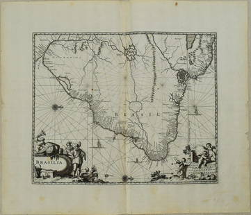
Sold20231671 Ogilby Map of Brazil -- BrasiliaTitle: 1671 Ogilby Map of Brazil -- Brasilia Cartographer: J Ogilby Year / Place: 1671, London Map Dimension (in.): 11.3 X 13.8 in. This is an excellent map of the eastern part of Brazil. There is anSee Sold Price
Sold2019Four engraved maps of Africa.Four engraved maps of Africa. Covens and Mortier 'Carte d' Afriique' and 'Carte de la Barbarie de la Nigritie et de la Guinee'; both after W. Delisle, hand coloured in outline, 55 x 68cm; a French mapSee Sold Price
Sold2018Carte de la Louisiane, Maryland... 1758. Map.[Southeastern US] Carte de la Louisiane, Maryland, Virginie, Caroline, Georgie, avec une Partie de la Floride. Amst: Covens & Mortier, 1758. C. Sepp Sculpsit:” at lower left. Labels the locations ofSee Sold Price
6 days LeftJasper521775-1780 Uruguay, Northern Argentina, Southern Brazil, and Rio de Janeiro. By Bonne & Raynal$30
May 09Hunt and Peck Estate Services, Inc.G. De L'Isle/Covens & Mortier Map Of Congo And The Country Of The Cafres$140
May 09Hunt and Peck Estate Services, Inc.G. De L'Isle/Covens & Mortier Map Of Egypt, Nubia, And Abissinia$140
6 days LeftJasper521775-1780 French Guiana. Dutch Guiana and Northern Brazil. By Bonne and Raynal.$30
May 15University ArchivesFeb. 1777 Issue of The Gentleman's Magazine with Superb Map of Philadelphia$140(1 bid)
6 days LeftJasper521680 Jansson/Duval Map of Middle East -- Tabula Itineris Decies Mille Graecorum sub Cyro Contra$140(1 bid)
4 days LeftTremont Auctions17th century Brazil original map. "Prefecturae Paranburae Pars Borealis" map by Blaeu. Sheet size:$200(1 bid)
6 days LeftTiberius AuctionsJohannes Covens and Cornelis Mortier, La Pologne Dressee sur ce qu'en ont donne Starovolsk,€50
May 14Akiba Galleries(2 Pc) Allain Manesson Mallet Description De L'Univers 2 Vol. German Translation$200(1 bid)
May 09Hunt and Peck Estate Services, Inc.1779 J. Carver "Travels Through The Interior Parts of North-America"$50
May 15University ArchivesScarce Early Printing: "An Account of the European Settlement in America in 6 Parts..."$100
May 16Zikorn Arts & History ObjectsAngelo Cannone: Coastal landscape in Naples, c.1930s Oil on Wood$200


![* DELISLE, Guillaume (1675-1726). Hemisphere: * DELISLE, Guillaume (1675-1726). Hemisphere Septentrional pour voir Plus Distinctoment les Terres Arctiques. [Paris:] Covens and Mortier, ca 1730. Engraved map of the Northern Hemisphere, image 462 x](https://p1.liveauctioneers.com/197/138502/70223753_1_x.jpg?height=310&quality=70&version=1553021482)
![* DELISLE, Guillaume (1675-1726). Hemisphere Occidental: * DELISLE, Guillaume (1675-1726). Hemisphere Occidental Dressee en 1720 pour l'usage particulier du Roy. [Paris:] Covens and Mortier, ca 1730. Engraved map of the Western Hemisphere, image 480 x 475 (](https://p1.liveauctioneers.com/197/138502/70223752_1_x.jpg?height=310&quality=70&version=1553021482)


![Carte de la Louisiane, Maryland... 1758. Map.: [Southeastern US] Carte de la Louisiane, Maryland, Virginie, Caroline, Georgie, avec une Partie de la Floride. Amst: Covens & Mortier, 1758. C. Sepp Sculpsit:” at lower left. Labels the locations of](https://p1.liveauctioneers.com/179/122672/62428349_1_x.jpg?height=310&quality=70&version=1527272450)


