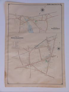
Sold2016Bridgehampton & Watermill, Long Island, 1902Original engraving published by E. Belcher Hyde from "Atlas of Suffolk County, Long Island, New York," Philadelphia, 1902. Map features family names, historic buildings and railroad routes. DimensionsSee Sold Price
Sold2016Town of Southampton Map (North Haven & Art Village),Original engraving of Southhampton town, including Peconic Bay, Hobson Island and many landmarks & family names. Published by E. Belcher Hyde from "Atlas of Suffolk County, Long Island, New York," 190See Sold Price
Sold2023E. Belcher Hyde Map Co. - Maps of Suffolk, Group of 4Lot 49 E. Belcher Hyde Map Co. American Manufacturer (fl. c. 1880 - 1920) Maps of Suffolk, Group of 4 (1916) lithograph with hand coloring from Suffolk County 1916 Vol 2 Long Island, New York, includeSee Sold Price
Sold2023E. Belcher Hyde Map Co. - Maps of Sag Harbor, Group of 2Lot 48 E. Belcher Hyde Map Co. American Manufacturer (fl. c. 1880 - 1920) Maps of Sag Harbor, Group of 2 (1916) lithograph with hand coloring from Suffolk County 1916 Vol 2 Long Island, New York 17 xSee Sold Price
Sold2022SUFFOLK COUNTY NEW YORK POLICE BADGE NO. 1058SUFFOLK COUNTY NEW YORK POLICE BADGE NO. 1058 Obsolete Suffolk County, New York Police badge. Numbered 1058. Unmarked. Measurements: 2.75 x 2.25"See Sold Price
Sold2022SUFFOLK COUNTY NEW YORK POLICE DETECTIVE BADGE NO. 110SUFFOLK COUNTY NEW YORK POLICE DETECTIVE BADGE NO. 110 Obsolete Suffolk County, New York Police Department Detective badge. Number 110. Unmarked. Measurements: 2 x 2.25"See Sold Price
Sold2022SUFFOLK CO NY POLICE DETECTIVE SERGEANT BADGE NO. 576SUFFOLK CO NY POLICE DETECTIVE SERGEANT BADGE NO. 576 Obsolete Suffolk County, New York Police Department Detective Sergeant badge. Numbered 576. Unmarked. Measurements: 1.5 x 1.5"See Sold Price
Sold2020Beers Map of Mechanicstown & Others New YorkBeers Map of Sparrowbush - Callrpernter's Point - Huguenot - Cuddebackville - Howells Depot - Circleville - Scotchtown - Mechanictown - Orange County, New York Scarce [Map]<See Sold Price
Sold2020Beers Map of Deer Park Orange Co. New YorkBeers Map of Deer Park, Orange County, New York Scarce [Map] Maker: F. W. Beers Dated: 1875 Type: Hand Colored Dimensions: 14 x 17 3/4"</See Sold Price
Sold2020Beers Map of Orange Co. New York 1875 - RareBeers Plan of Orange County, New York Scarce [Map] Maker: F. W. Beers Dated: 1875 Type: Hand Colored Dimensions: 14 x 17 3/4" CondSee Sold Price
Sold20241881 Westchester County New York Yonkers Illustrated MAPS 2v SET Bolton History1881 Westchester County New York Yonkers Illustrated MAPS 2v SET Bolton History Robert Boltons “History of County of Westchester” is a rare, 19th-century survey of towns and manors throughoutSee Sold Price
Sold2021Antique 1858 Wall Map of Columbia County,NY New YorkLarge antique c.1858 map of Columbia county New York. This large map has lots of great details. It is perfect for anyone interested in local Hudson Valley history. The dimensions are 57in x 66in x 1.5See Sold Price
Sold20211870 Mitchell Map of New York -- County Map of theTitle: 1870 Mitchell Map of New York -- County Map of the State of New York Cartographer: S Mitchell Year / Place: 1870, Philadelphia Map Dimension (in.): 13.7 X 21 in. This is an excellent map of theSee Sold Price
Sold20181876 Mitchell Map of New York -- County Map of theReserve Reduced! Title/Content of Map: 1876 Mitchell Map of New York -- County Map of the State of New York Date: 1876 Philadelphia Cartographer: S Mitchell Size: 13.5 x 21.3 in. A very nice, large maSee Sold Price
Sold2021Antique New York State Map 1903 Color Roll Up RR Map1903 Scarborough's New Railroad, Post Office, Township and County Map of New York. Color map, compiled from the latest government and state surveys and original sources of the era. Insets: Map of NewSee Sold Price
Sold2019Vintage Road Maps (14)Including 1980-1981 New Jersey map & guide; (3) Somerset & Hunterdon Counties New Jersey map; Burlington Bridges Area Road map; Northern Hunterdon County, NJ map; Sunoco New York map; Texaco Florida,See Sold Price
Sold2019LARGE WALL MAP ULSTER COUNTY NEW YORKLARGE WALL MAP ULSTER COUNTY NEW YORK-OLIVER TILLSON, C. 1853 44" X 54"See Sold Price
Sold2016Wall Map Rockland County New York, 1854WALL MAP ROCKLAND COUNTY NEW YORK, 1854 Surveyed and Published by R.F.O' Connor, New York Dimension: 46.6" x 34" Condition: Good , no stains or repairs. General handling wear. Provenance: Private EstaSee Sold Price
Sold2018Map, "Delaware County, New York, Philadelphia, 1856Map, "Delaware County, New York, From Actual Survey by Jay Could, Published by Collins G. Keeney, Philadelphia, 1856, various county scenes on top margin, map is damages with some loss at top, size isSee Sold Price
Sold2016U.S. 1929 $20 National Bank NoteThe Suffolk County National Bank of Riverhead, New York, (#4230), KL #1317, Fr #1802-1, Type 1. Very Fine condition.See Sold Price
Sold2023Early Wall Map of Dutchess Putnam New York, David Burr 1839Early Wall Map of Dutchessand Putnam County New York, David Burr 1839. Antique map in scroll format with thick dark painted wood supports features cities of the period including Poughkeepsie, RhinebecSee Sold Price
Sold2018MAP OF ULSTER COUNTY NEW YORK, 1853MAP OF ULSTER COUNTY NEW YORK, TILLSON 1853 52" X 54"See Sold Price
Jun 08Early American History Auctions1836 Hand-Colored Map, Country Twenty Five Miles Round The City Of New-York Published by D.S. Stone$260
Featured12 hrs LeftJasper521867 Beers Map of New York City Area -- Map of New York and Vicinity Accompanying "Atlas of New York$200
12 hrs LeftJasper521874 Holmes Plan of New York's Upper East Side -- Map of the Common Lands from 76th to 93rd Street$750


![Beers Map of Mechanicstown & Others New York: Beers Map of Sparrowbush - Callrpernter's Point - Huguenot - Cuddebackville - Howells Depot - Circleville - Scotchtown - Mechanictown - Orange County, New York Scarce [Map]<](https://p1.liveauctioneers.com/5614/168598/85022158_1_x.jpg?height=310&quality=70&version=1589319430)
![Beers Map of Deer Park Orange Co. New York: Beers Map of Deer Park, Orange County, New York Scarce [Map] Maker: F. W. Beers Dated: 1875 Type: Hand Colored Dimensions: 14 x 17 3/4"</](https://p1.liveauctioneers.com/5614/168598/85022156_1_x.jpg?height=310&quality=70&version=1589319429)
![Beers Map of Orange Co. New York 1875 - Rare: Beers Plan of Orange County, New York Scarce [Map] Maker: F. W. Beers Dated: 1875 Type: Hand Colored Dimensions: 14 x 17 3/4" Cond](https://p1.liveauctioneers.com/5614/168598/85022155_1_x.jpg?height=310&quality=70&version=1589319430)


