Sold2023Early Wall Map of Dutchess Putnam New York, David Burr 1839Early Wall Map of Dutchessand Putnam County New York, David Burr 1839. Antique map in scroll format with thick dark painted wood supports features cities of the period including Poughkeepsie, RhinebecSee Sold Price
Sold20211839 MAP OF ULSTER COUNTY, NEW YORK, BY DAVID H. BURR,1839 MAP OF ULSTER COUNTY, NEW YORK, BY DAVID H. BURR, STONE & CLARK PUBLISHERS, ITHICA, N.Y. NICELY FRAMED, FROM PROMINENT ELLENVILLE, N.Y. ATTORNEYS OFFICE. MAP MEASURES 22" X 23", NICELY FRAMED, ANSee Sold Price
Sold2024Pre-Central Park Map of New York City, David H. Burr / Simeon DeWitt 1829Sight size 21" x 50.5" framed to 24.75" x 54.5". Some tears and seams with attempts at repair, foxing and toning, not examined out of frame.See Sold Price
Sold2021Antique 1858 Wall Map,Dutchess County,NY Rhinebeck,EtcAntique 1858 Wall Map,Dutchess County,NY Rhinebeck,Etc. This Large detailed antique map of Dutchess county New York is dated 1858. This large map has lots of great little details including drawings anSee Sold Price
Sold2021(NEW YORK.) David H. Burr. Hudson River & Vicinity.(NEW YORK.) David H. Burr. Hudson River & Vicinity. Engraved strip map of the Hudson River from lower Warren County to New York City. 24¾x4½ inches extended, folding into publisher's 12mo foSee Sold Price
Sold202119th Century Maps of the New York City Area and the19th Century Maps of the New York City Area and the State of New Jerseyas follows: Map of the Country Twenty Five Miles Round the City of New - York (New York: David H. Burr, 1831), centered on ManhatSee Sold Price
Sold2019Map of the City of New-York,Reserve Reduced! Title: Map of the City of New-York, Publication Date: 1836 Cartographer: BURR, DAVID H. Publisher: J. DISTURNELL Size (inches): 12 x 10.6 for 'New York as it is in 1836.' Population 2See Sold Price
Sold2016Map Of The Town Of Northeast New YorkEarly map of "Town Of Northeast/Dutchess Co. N.Y.". Sight 17 1/2" x 14".See Sold Price
Sold2024BURR, David A. (1803-1875). Ohio. New York City, New York, 1831.BURR, David A. (1803-1875). Ohio. New York City, New York, 1831. Engraved map of the state of Ohio, visible area 10 1/8 x 12 1/2 inches. Showing counties, towns, and cities, with accurate road systemsSee Sold Price
Sold2023Civil War Era Itemsitems to include: Epaulette, Solider tin type, brass bleeder in case, pewter snuff box, powder horn with dog, early 1800's fork in leather case, Burr's map of New York State 1835 in poor condition, 18See Sold Price
Sold2018Illman & Pilbrow Map of Oregon Territory, 1833David H. Burr (American, 1803-1875), "Oregon Territory", engraved by Illman & Pilbrow, 1833. Publisher - New York: D.S. Stone. Printed by Cammeyer & Clark, New York. According to the statement below tSee Sold Price
Sold201914 vols on Rivers & Lakes. Early 20th c.[Americana] G.P. Putnam Sons, New York, 1901-1911. 8vo. All but 1 vol in blue cloth and gilt binding with top edges gilt. All maps included. Including: (1) Curwood, James Oliver. The Great Lakes and tSee Sold Price
Sold2018Two hand colored two part maps of Rockefellerland toTwo hand colored two part maps of Rockefellerland to include Pocantico Hills New York, Westchester County and Area for Early Action. 45" x 39 1/2" each Provenance: Estate of Peggy & David RockefellerSee Sold Price
Sold2021Rare Tiffany Studios New York Bronze Three Armed WallRare Tiffany Studios New York Bronze Three Armed Wall Sconce Early 20th century. With three blown Tiffany Favrile decorated "Pulled Feather" shades. Greenish brown patina. Literature: Alastair Duncan,See Sold Price
Sold2021Dutch Nicolaes Visscher I Map of New Amsterdam, ca 1690Nicolaes Visscher I. Map of Northeast with Early View of New York City. Ca. 1690 to 1729. A finely hand-colored example of Nicolaes Visscher I's illustrated map of the Northeast of America with an insSee Sold Price
Sold20221836 Map of 25 Miles Round The City Of New-York.Historic Maps 1836 "Map of the Country Twenty Five Miles Round The City Of New-York." Published by D.S. Stone November 11, 1836-Dated, Hand-Colored Map titled, "Map of the Country Twenty Five Miles RoSee Sold Price
Sold2022Canot's Pair of Early New York Views, 1768CANOT, Pierre Charles (1710-1777), after HOWDELL, Thomas (18th Century). A South West View of the City of New York in North America [WITH] A South East View of the City of New York in North America. ESee Sold Price
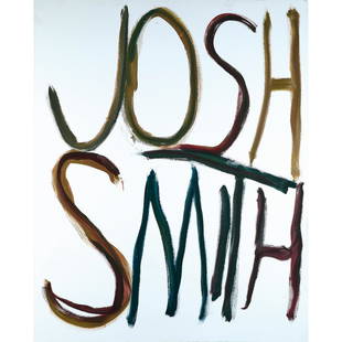
Sold2022Josh Smith (born in 1976) Untitled (JSP07403), 2007Josh Smith (born in 1976)Untitled (JSP07403), 2007Oil on canvasSigned, dated, and titled on the reverse152,5 x 123 cmProvenance :- Luhring Augustine Gallery, New York- David Zwirner Gallery, Paris- PrSee Sold Price
Sold2022(2) Alice Baber (American, 1928-1982) "Along the Way" &(2) Alice Baber (American, 1928-1982) "Along the Way" & "Lucky Number" 1962-63. Oil on canvas. Each signed 'Baber' (lower right). Both 18 1/2 x 7 1/2 in. Anderson Gallery, Buffalo, New York. David K.See Sold Price
Sold2021William Scott (Irish, 1913-1989) Green PearsWilliam Scott (Irish, 1913-1989) Green Pears Lithograph on paper. Signed 'W. Scott 74' (upper left) and numbered edition 52/75. 8 1/4 x 10 1/4 in. Anderson Gallery, Buffalo, New York. David K. AndersoSee Sold Price
Sold2024Goerck's 1785 working survey of the Common Lands that became Fifth Avenue[MAP-NEW YORK] [GOERCK, CASIMIR, attributed to]. A manuscript survey of the Manhattan Common Lands, dated 1785. A manuscript survey plan in ink on joined sheets, with irregular edges but the image subSee Sold Price
Sold2024Lot 5 Vintage Illustrated Books, A.W. COYSH +Five vintage illustrated books about collectibles. Lot includes: - PICTURES OF EARLY NEW YORK ON DARK BLUE STAFFORDSHIRE POTTERY, R. T. HAINES HALSEY, 1974. - The Royal Copenhagen Porcelain ManufactorSee Sold Price
Sold2015A Fine & Rare Map of New York.Bernard Ratzer "Plan of the City of New York". Signed lower right in the plate "T. Kitchin Sculpt" (Kitchin recorded the cartographer's name as Ratzen (sic) rather than Ratzer). The map backed, rolledSee Sold Price
Sold2023Old Trinity by Guy Carleton WigginsGuy Carleton Wiggins (1883 - 1962) United States of America. Old Trinity, depicting 3 American flags. Oil on Canvas. 17.25 x 14.5 (framed), 11.5 x 8.5 (canvas). "Old Trinity at Wall Street, New York"See Sold Price
May 16Potter & Potter Auctions[NEW YORK CITY – PICTORIAL MAPS]. Group of 3 pictorial maps...$200(1 bid)
BonhamsTIFFANY STUDIOS LAMP SHADE NO. 1425, New York, New York, early 20th century, partly illegible im...$1,100(3 bids)
2 days LeftBucklinShore, Stephen [SIGNED]; Stereographs New York, 1974 [LTD ED #/400 stereograph viewer with 5 reels]$200(1 bid)
3 days LeftTremont AuctionsJohn Speed and Francis Lamb "Map of New England and New York", ca. 1676. Hand colored engraved map$900(3 bids)
May 19The Heritage Gallery at Sayville Antiques, IncArthur B. Davies Early 20th c. O/C Ethereal Modern Landscape$275(2 bids)


![14 vols on Rivers & Lakes. Early 20th c.: [Americana] G.P. Putnam Sons, New York, 1901-1911. 8vo. All but 1 vol in blue cloth and gilt binding with top edges gilt. All maps included. Including: (1) Curwood, James Oliver. The Great Lakes and t](https://p1.liveauctioneers.com/179/136599/69322193_1_x.jpg?height=310&quality=70&version=1550270345)


![Canot's Pair of Early New York Views, 1768: CANOT, Pierre Charles (1710-1777), after HOWDELL, Thomas (18th Century). A South West View of the City of New York in North America [WITH] A South East View of the City of New York in North America. E](https://p1.liveauctioneers.com/1968/250616/130196530_1_x.jpg?height=310&quality=70&version=1654190895)


![Goerck's 1785 working survey of the Common Lands that became Fifth Avenue: [MAP-NEW YORK] [GOERCK, CASIMIR, attributed to]. A manuscript survey of the Manhattan Common Lands, dated 1785. A manuscript survey plan in ink on joined sheets, with irregular edges but the image sub](https://p1.liveauctioneers.com/292/326828/175962863_1_x.jpg?height=310&quality=70&version=1713473479)


![[NEW YORK CITY – PICTORIAL MAPS]. Group of 3 pictorial maps... (1 of 3)](https://p1.liveauctioneers.com/928/325952/175495562_1_x.jpg?height=282&quality=70&version=1712935174)


![Shore, Stephen [SIGNED]; Stereographs New York, 1974 [LTD ED #/400 stereograph viewer with 5 reels] (1 of 6)](https://p1.liveauctioneers.com/8658/325945/175540442_1_x.jpg?height=282&quality=70&version=1712964944)


