Sold2017Plan of the City and Suburbs of New Orleans"Plan of the City and Suburbs of New Orleans; from An Actual Survey Made in 1815", by Jacques Tanesse, facsimile published Ithaca, New York: Historic Urban Plans, 1967, after the original published bySee Sold Price
Sold2022PHILADELPHIA FOLIE (A.P.) To Thomas Mifflin Governor and Commander in Chief of the State of Penn...PHILADELPHIA FOLIE (A.P.) To Thomas Mifflin Governor and Commander in Chief of the State of Pennsylvania this Plan of the City and Suburbs of Philadelphia is Respectfully Inscribed by the Editor, 1794See Sold Price
Sold2023Map Of Philadelphia 1794 Thomas Mifflin GovernorMap Of Phila 1794, Thomas Mifflin Governor and Commander in Chief of the State of Pennsylvania. Plan for the City and Suburbs of Philadelphia. 1973 reproduction, #38 of 500, Historical Urban PlansSee Sold Price
Sold2024A scarce and very large plan of Montreal[MAP-CANADA] ADAMS, JOHN, surveyor. Map of the City and Suburbs of Montreal ... Constructed from a New Survey, 1825 by John Adams. New York: Engraved by J. D. Stout, 1825. Engraved map on three largeSee Sold Price
Sold2016Plan of the City of Breda (Netherlands). van Goor.Detailed plan of the city of Breda. Grondt Tekening der Stadt Breda (Netherlands). Index in top left and bottom right corner numbered from 1 to 66. Index at bottom out-side plate A to Z. Bottom rightSee Sold Price
Sold2021Delisle, Covens & Mortier 1739 Map of FranceMap of Narbonne, France engraved by Delisle/Covens & Mortier depicting churches, parishes, abbeys, roads, and villages. Also included is an inset plan of the fortified city with index table. ConservatSee Sold Price
Sold2018Map of the City of Somerville. 1896.Title: Map of the City of Somerville. 1896. Date: 1896 Cartographer: BAILEY, ERNEST W. Size: 17.6 X 29.5 Street plan of a city on the Mystic River between Cambridge and Medford, suburbs of Boston. GeoSee Sold Price
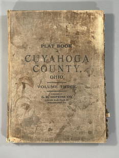
Sold2023Plat Book of the City of Cleveland, Ohio, Volume Three 1914Philadelphia: G.M. Hopkins, 1914. This atlas was issued as Volume 3 of the title Plat-book of the city of Cleveland, Ohio and suburbs, complete in two volumes from official records, private plans andSee Sold Price
Sold20221828 MAP of New York City Suburbs Railroads New Jersey EC Bridgman Color1828 MAP of New York City Suburbs Railroads New Jersey EC Bridgman Color An impressive, 19th-century map of New York City and its surrounding environs. This E.C. Bridgman map is a huge map folded intoSee Sold Price
Sold2024History, Antiquities of City Suburbs of WorcesterThe History And Antiquities of the City and Suburbs of Worcester 1796. This two-volume set of books is titled ?The History And Antiquities Of The City And Suburbs Of Worcester?, written by Valentine GSee Sold Price
Sold20191705 Engraved Plan City of Leige by De Fer1705 plan by Nicolas de Fer of the city of Liege, printed at Paris. Fine engraving . Measures 16 x 11”. Reserve: $20.00 Shipping: Domestic: Flat-rate of $5.00 to anywhere within the contiguous U.S.See Sold Price
Sold2021Boxing Rubin Olivares signed 10x8 photo. RubénBoxing Rubin Olivares signed 10x8 photo. Rubén Olivares Avila (born January 14, 1947) in Bondojito, a Mexico City's suburb, is a Mexican former boxer and actor, and a member of the International BoSee Sold Price
Sold2022Bristol.- New History, Survey and Description of the City and Suburbs of Bristol (The), firstBristol.- New History, Survey and Description of the City and Suburbs of Bristol (The), first edition, folding engraved map, Bristol, Printed, Published and Sold by W. Matthews, 1794; bound with MatthSee Sold Price
Sold2023Bethlehem pictorial bird's eye view city plan. Israel. #104. BOLLMANN 1970 mapTitle: Bethlehem pictorial bird's eye view city plan. Israel. #104. BOLLMANN 1970 map Description: Bethlehem' by Hermann Bollmann (1970). Vintage axonometric "bird's eye view" city tourist plan, 54.5See Sold Price
2024City plan of the Foreign Settlements in Shanghai, China by Carl Crow 1921 mapCAPTION PRINTED BELOW PICTURE: 'Plan of the Foreign Settlements - Shanghai - drawn for Crow's "Handbook for China"' DATE PRINTED: 1921 IMAGE SIZE: Approx 24.5 x 36.0cm, 9.5 x 14 inches (Large); PleaseSee Sold Price
Sold2019Acapulco'. Mexico. Town city plan. BELLIN / SCHLEY 1757TITLE/CONTENT OF MAP: 'Acapulco [Acapulco]' This map is folding hence the centrefold line may show on the image below DATE PRINTED: 1757 IMAGE SIZE: Approx 24.0 x 34.5cm, 9.5 x 13.5 inches (Large); PlSee Sold Price
Sold20181859 version of 1664 New York City Plan -- The "Duke'sReserve Reduced! Title/Content of Map: 1859 version of 1664 New York City Plan -- The "Duke's Plan" A Description of the Towne of Mannados or New Amsterdam as it was in September 1661 . . . Anno DominSee Sold Price
Sold2021Shanghai'. Shanghai antique town city plan. China 1915TITLE/CONTENT OF MAP: Shanghai [Shanghai] The top image on the right hand side shows the entire map. To view a close up of the map showing the level of printed detail, please click on the bottom imageSee Sold Price
Sold2019Plan de la Ville de Meaco'. Kyoto town city plan,TITLE/CONTENT OF MAP: 'Plan de la Ville de Meaco A.Quartier de Dayri ou Empereur hereditaire B. Palais du Cubosama [Plan of the city of Kyoto]' DATE PRINTED: 1752 IMAGE SIZE: Approx 20.5 x 29.0cm, 8 xSee Sold Price
Sold2016Map of New York City & Plan of Fort Washington (PortEngraved by George Hayward for D.T. Valentine's Manual. Map features northern Manhattan with Revolutionary War battles and troop movements, hightlighted by number on right side of map. The full titleSee Sold Price
Sold2017SDUK: Antique Map, City Plan of Philadelphia, 1847Title/Content of Map: 'PHILADELPHIA' Antique town city map plan. Inset US Bank, Exchange. Date Printed: 1847 Image Size: Approx 39.5 x 31.5cm, 15.5 x 12.5 inches (Large) Type: Antique steel engraved mSee Sold Price
Sold2021Town city 'Plan de la Ville de Louvo'. Lopburi,TITLE/CONTENT OF MAP: 'Plan de la Ville de Louvo [Plan of the city of Lopburi]' The top image on the right hand side shows the entire map. To view a close up of the map showing the level of printed deSee Sold Price
Sold2020MOSCOW . Decorative city plan. Russia. 'Moscou'.TITLE OF THE MAP: 'Moscou' DATE PRINTED: 1683 IMAGE SIZE: Approx Overall page size 13 x 21cm approximately (5 x 8 inches); image size 10.5 x 14.5cm approximately (4 x 5.5 inches) TYPE: Original 17th cSee Sold Price
Sold2023City plan of Paris. Jacobs, c.1850Paris France detailed city plan c.1850. Fine large engraved map by Jacobs. Published by Furne in Paris.; Numbered key identifies important buildings and locations. Inset lower left of the environs ofSee Sold Price
3 days LeftJasper521861 Mitchell Map of Washington DC -- Plan of the City of Washington The Capitol of the United$70
5 days LeftZikorn Arts & History ObjectsCity of Tripoli 1685 Attack by French Navy, Color Engraving$400
3 days LeftJasper521614 Munster View of Utrecht Netherlands -- Von der Bischofflichen Statt Utrecht$70
3 days LeftJasper52Bellin Map of St. Salvador, Brazil -- Plan de la ville de St. Salvador [with] Vue de la Ville de St.$55
Jun 06Freeman's | HindmanKING, Stephen (b. 1947). Pet Sematary. Garden City: Doubleday & Company, Inc., 1983.$250


![A scarce and very large plan of Montreal: [MAP-CANADA] ADAMS, JOHN, surveyor. Map of the City and Suburbs of Montreal ... Constructed from a New Survey, 1825 by John Adams. New York: Engraved by J. D. Stout, 1825. Engraved map on three large](https://p1.liveauctioneers.com/292/326828/175962870_1_x.jpg?height=310&quality=70&version=1713473479)


![Acapulco'. Mexico. Town city plan. BELLIN / SCHLEY 1757: TITLE/CONTENT OF MAP: 'Acapulco [Acapulco]' This map is folding hence the centrefold line may show on the image below DATE PRINTED: 1757 IMAGE SIZE: Approx 24.0 x 34.5cm, 9.5 x 13.5 inches (Large); Pl](https://p1.liveauctioneers.com/5584/138985/70466044_1_x.jpg?height=310&quality=70&version=1554250661)

![Shanghai'. Shanghai antique town city plan. China 1915: TITLE/CONTENT OF MAP: Shanghai [Shanghai] The top image on the right hand side shows the entire map. To view a close up of the map showing the level of printed detail, please click on the bottom image](https://p1.liveauctioneers.com/5584/192167/96862541_1_x.jpg?height=310&quality=70&version=1611703298)
![Plan de la Ville de Meaco'. Kyoto town city plan,: TITLE/CONTENT OF MAP: 'Plan de la Ville de Meaco A.Quartier de Dayri ou Empereur hereditaire B. Palais du Cubosama [Plan of the city of Kyoto]' DATE PRINTED: 1752 IMAGE SIZE: Approx 20.5 x 29.0cm, 8 x](https://p1.liveauctioneers.com/5584/156033/78750029_1_x.jpg?height=310&quality=70&version=1575421548)


![Town city 'Plan de la Ville de Louvo'. Lopburi,: TITLE/CONTENT OF MAP: 'Plan de la Ville de Louvo [Plan of the city of Lopburi]' The top image on the right hand side shows the entire map. To view a close up of the map showing the level of printed de](https://p1.liveauctioneers.com/5584/200280/101303623_1_x.jpg?height=310&quality=70&version=1618350002)


![Bellin Map of St. Salvador, Brazil -- Plan de la ville de St. Salvador [with] Vue de la Ville de St. (1 of 1)](https://p1.liveauctioneers.com/5584/328338/176911634_1_x.jpg?height=282&quality=70&version=1715113718)


