Sold2015Map of North America 1719Heading: (North America) Author: Sanson, Nicolas/ Hubert Jaillot Title: Amerique Septentrionale divisée en ses Principales Parties, ou sont distingués les uns des autres les Estats suivant quils appSee Sold Price
Sold2020Jacques Chiquet North America Map 1719 CaliforniaJacques Chiquet (1673-1721), "L'Amerique Septentrionale qui fait partie des Indes Occidentales," Paris, 1719. This excellent hand colored map of North America includes a depiction of California as anSee Sold Price
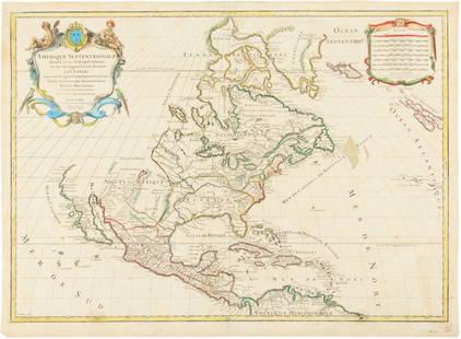
Sold20241719 Map of Colonial era North America, by Sanson - JaillotTitle: 1719 Map of Colonial era North America, by Sanson - Jaillot Date/Period: 1719 Materials: Copperplate engraved Size: 25 1/2 x 18” This map is a rare and valuable map of history, showing NoSee Sold Price
Sold2020John Senex Map of North and South America 1719-17John Senex (1678–1740), "A New Map of America from the Latest Observations," London, ca. 1719-1721. Hand colored copperplate engraved map of North and South America, from Senex's "New General ASee Sold Price
Sold2021A GEORGE II FRENCH AND INDIAN WAR PERIOD MAP, "A Map ofA GEORGE II FRENCH AND INDIAN WAR PERIOD MAP, "A Map of the British and French Settlements in North America," LONDON, CIRCA 1755, hand-colored engraving on paper, by John Lodge Cowley (1719-1797), carSee Sold Price
Sold2017Edward Wells, map North AmericaEdward Wells, map North America, Edward Wells (British, 1667-1727), "A New Map of North America Shewing its Principal Divisions, Chief Cities, Townes... Dedicated to His Highness William Duke of GloucSee Sold Price
Sold20211752 Four Section Maps North AmericaAll four sections of a wall map of North America arranged for Malachy Postlethwayte for his publication "Dictionary of Trade and Commerce". The maps are based on a work by the French mapmaker D'AnvillSee Sold Price
Sold2020Early Hand Colored Map North America by T ConderAntique framed hand colored early map of North America. Top left image of Native man and foliage, reads "North America agreeable to the most approved Maps and Charts, by Thomas Condor" Frame: 14 3/4 iSee Sold Price
Sold2024de Vaugondy. Nouvel Atlas Portratit de la Geographie Ancienne (Atlas / Map / North America / Southde Vaugondy. Nouvel Atlas Portratit de la Geographie Ancienne (Atlas / Map / North America / South America / DeVaugondy Atlas). Paris: A Paris chez l'Auteur Rue du Foin St. Jacques, 1790. New Edition.See Sold Price
Sold2020L'amerique Septentrionale 1706 Map North AmericaL'amerique Septentrionale 1706 Map Of North America (french). 24 X 20 Inches, Framed.See Sold Price
Sold2016[Map] New Map North America 1855Jacob Monk ,Baltimore; North America and Territories, Canada,Central America and West Indies, 57 x 62 in. Large Roll down map.See Sold Price
Sold2016Map, North America, Tallis, C. 1850This engraved map of North America from 1850 includes illustration taking the form of nine vignettes: Esquimaux Dog-Sledge, Cossacks, Wapiti Deer, North American Indians, Ancient Monument in Mexico, CSee Sold Price
Sold20232 Framed Historical Maps, North America & Kentucky, Carey & Lea1st item: Geographical, Statistical & Historical map of North America, 1823, published by Henry Charles Carey (1793-1879) and Isaac Lea (1792-1886) Philadelphia, illustrated by J. Yeager. From A ComplSee Sold Price
Sold2022A REPUBLIC OF TEXAS MAP, "North America," CHAPMAN & HALL, BRITISH, 1843,A REPUBLIC OF TEXAS MAP, "North America," CHAPMAN & HALL, BRITISH, 1843, hand colored engraving on paper, Published by Chapman & Hall...under the Superintendence of the Society for the Diffusion of UsSee Sold Price
Sold2022Barclay, James C1800 Hand Col Map. North America. RareRare impression with contemporary hand color. By uncommon Publishers Lawson's of Halifax. Hand Colored Copper Engraved Map Published C1800 Halifax & Newcastle, England for "Barclay's Universal EnglishSee Sold Price
Sold2021Barlow 1807 Antique Map. North AmericaCopper Engraved Map Published 1807 by Brightly & Kinnersley, Bungay, England for "A General View of the World, Geographical, Historical and Philosophical" by The Rev. E. Blomfield. Engraved by Barlow.See Sold Price
Sold2021MAP, North America, LevasseurNorth America. Victor Levasseur, Amerique Septentrionale, from Atlas Universel Illustre, 1835 (circa). Hand Color. This early version of Levasseur's decorative map of North America shows Mexico in conSee Sold Price
Sold2023Brookes & Baker 1797 Antique Map. North AmericaCopper Engraved Map Published 1797, London for "The General Gazetteer; Or, Compendious Geographical Dictionary" by Richard Brookes. Engraved by B. Baker. Original outline hand color. Folds as issued.See Sold Price
Sold2024Aitchison, Alexander 1799 Hand Col Map. North America"An Accurate Map of North America with the New Discoveries 1796" Hand Colored Copper Engraved Map Published 1798-99, London for "The Modern Gazetteer; Being a compendious Geographical Dictionary?" bySee Sold Price
Sold2021Wilkes, John 1796 Map. North AmericaCopper Engraved Map Published 1796-1828 London for "Encyclopaedia Londinensis, or universal dictionary of arts, sciences and literature" by John Wilkes et al. Paper Size: 10.5 x 8.5 inch (27 x 22cm) ISee Sold Price
Sold20191855 Map North America by G. Virtue1855 map of North America by G. Virtue. Measures 13.375 in. x 9.875 in. G-VG/VG. Unframed, loose and not glued or mounted. If lot is absent of a condition report a condition report may be requested viSee Sold Price
Sold2023Barclay, James C1800 Rare Hand Col Map. North AmericaRare impression with contemporary hand color. By uncommon Publishers Lawson's of Halifax. Hand Colored Copper Engraved Map Published C1800 Halifax & Newcastle, England for "Barclay's Universal EnglishSee Sold Price
Sold2021Tallis, John (Pub) 1852 Map. North AmericaSteel Engraved Map with Original Outline Hand Color Published 1852-56 by John Tallis, London for "The Universal Pronouncing Dictionary" by Thomas Wright. Drawn & Engraved by John Rapkin. Centre fold aSee Sold Price
Sold2024Russell & Allen (Pub) 1812 Map. North America. USA CanadaFolio Copper Engraved Map Published 1812 by Russell and Allen, Manchester for "A New And Commercial System Of Geography" Paper Size: 15.5 x 9 inch (39 x 23cm) Minor toning, otherwise Good ConditionSee Sold Price
3 days LeftPotter & Potter AuctionsSTORM, Mark. Official Texas Brags Map of North America. 194...$200(1 bid)
2 days LeftUniversity ArchivesDeclaration of Independence, Very Early British Publ. in Gentleman's Magazine & Rare Map$1,000
May 26GOLDEN SUN AUCTIONS, Inc. (formerly Appraisal & Estate Sale Specialists, Inc.)William Guthries British Colonies of North America Map Circa 1800$40
4 days LeftAlbion AuctionsClarke & Russell 1814 Hand Col Map. Canada - British Dominions in North America$25(3 bids)
2 days LeftUniversity ArchivesScarce Early Printing: "An Account of the European Settlement in America in 6 Parts..."$100
Jun 07Freeman's | HindmanHOMANN, Johann Baptist. Amplissimae Regionis Mississipi Seu Provinciae Ludovicianae. Nuremburg, [ca$400
May 30NY Elizabeth ANTIQUE MAP-ILLUSTRATED FLORAL ILLUSTRATION 1761 NEW DICTIONARY OF TRADE AND COMMERCE R. ROTH$50
5 days LeftTHOS. CORNELL GALLERIES, LTD.GROUP OF ANTIQUE AND VINTAGE MAPS, INC.. NORTH AND SOUTH AMERICA, WORLD MAPS, LOSSES THROUGHOUT,$100(1 bid)
Jun 07Freeman's | HindmanHARMON, Daniel Williams. A Journal of Voyages and Travels in the Interiour of North America. 1820.$450(2 bids)
4 days LeftAlbion AuctionsBlackie (Pub) 1882 Pair of Maps. USA - Atlantic States & Mississippi Valley$5
5 days LeftTrillium Antique Prints & Rare BooksAudubon, Imperial Folio - Common American Skunk. 42$400(2 bids)
5 days LeftTrillium Antique Prints & Rare BooksKarl Bodmer - Bison-Dance of the Mandan Indians in front of their Medicine Lodge in Mih-Tutta$300
5 days LeftTrillium Antique Prints & Rare BooksKarl Bodmer - The Elkhorn Pyramid on the upper Missouri. 21$300


![[Map] New Map North America 1855: Jacob Monk ,Baltimore; North America and Territories, Canada,Central America and West Indies, 57 x 62 in. Large Roll down map.](https://p1.liveauctioneers.com/523/85328/43939935_1_x.jpg?height=310&quality=70&version=1455914464)


