Sold2020Jacques Chiquet North America Map 1719 CaliforniaJacques Chiquet (1673-1721), "L'Amerique Septentrionale qui fait partie des Indes Occidentales," Paris, 1719. This excellent hand colored map of North America includes a depiction of California as anSee Sold Price
Sold20241792 MAP OF NORTH AMERICA BY JACQUES CHIQUETSuperb engraved and hand-colored map of North America by French cartographer Jacques Chiquet, 9 x 6.75 in. (sight), very boldly and sharply printed. Set into an elaborate and most attractive double maSee Sold Price
Sold20201798 Monterey California North America MapTitle: Plan de la Baie de Monterey" - Monterey California North America map Karte Amerika Atlas du Voyage de la Perouse. Published: by G.G. & J. Robinson, Pater-noster Row. Size: Artwork: 10 x 15 1/2See Sold Price
Sold2024A rare dated 1722 North America mapA rare dated 1722 North America map, the map covers Mexico, California to Florida, condition fair, 21.2"x25"See Sold Price
Sold20241719 Map of Colonial era North America, by Sanson - JaillotTitle: 1719 Map of Colonial era North America, by Sanson - Jaillot Date/Period: 1719 Materials: Copperplate engraved Size: 25 1/2 x 18” This map is a rare and valuable map of history, showing NoSee Sold Price
Sold2020Seale map of North America California an islandHeading: Author: Seale, Richard William Title: A Map of North America with the European Settlements & whatever else is remarkable in ye West Indies, from the latest and best Observations Place PublisSee Sold Price
Sold2024Seale map of North America California an islandHeading: (North America) Author: Seale, Richard William Title: A Map of North America with the European Settlements & whatever else is remarkable in ye West Indies, from the latest and best ObservatioSee Sold Price
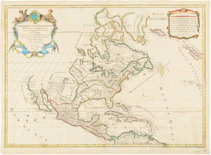
Sold2015Map of North America 1719Heading: (North America) Author: Sanson, Nicolas/ Hubert Jaillot Title: Amerique Septentrionale divisée en ses Principales Parties, ou sont distingués les uns des autres les Estats suivant quils appSee Sold Price
Sold20171749 MAP CALIFORNIA AS AN ISLAND, JACQUES CHIQUETFramed map, c. 1749, "L’AMERIQUE SEPTENTRIONALE qui fait partie des Indes Occidentales. Dressée selon les dernieres Relations des Voiageurs et Suivant les nouvelles Observations de Mur. de lSee Sold Price
Sold2024Rare Antique Map - Hudson Bay Chart - Old Map of North America - Bellin - Jacques"Carte de la Baye de Hudson". Its finely engraved, hand-coloring engraved map from the Dutch edition of acques Nicolas Bellin Histoire "General of Travel". Published in Amsterdam. A handsome chart ofSee Sold Price
Sold2021Maps of North America, California, and the Great LakesMaps of North America, California, and the Great Lakes RegionSee Sold Price
Sold2017Jaillot: Antique Map of North America, 1696Map: 1696 Jaillot Map of North America (California as an Island) -- Amerique Septentrionale Divisee en ses Principales Parties Date Printed: 1696 Amsterdam Cartographer: H. Jaillot Size: 19.3 x 23 in.See Sold Price
Sold2023(NORTH AMERICA.) Henricus Hondius. America Septentrionalis.(NORTH AMERICA.) Henricus Hondius. America Septentrionalis. Double-page engraved map of North America with California as an island and attractive carto-ornamentation. 19¼x23½ inches sheet siSee Sold Price
Sold2016Hubert Jaillot. Amerique Septentrionale diviséeHubert Jaillot. Amerique Septentrionale divisée en ses principales parties<See Sold Price
Sold2017van der Aa: T Noorder deel Vaa Amerika, 1707Map: T Noorder deel Vaa Amerika Maker: Peiter van der Aa Date: 1707 Description: Map of North America with California shown as an island. Many place names on California's west coast Size: 8 x 11.8 incSee Sold Price
Sold20241st ed. of Moll’s fascinating 1701 map of Isle of CaliforniaHerman Moll's renowned and highly sought-after map showing California as an island, plus the western part of North America. This is the first appearance of this map, with page number 152 clearly shownSee Sold Price
Sold2024de Vaugondy. Nouvel Atlas Portratit de la Geographie Ancienne (Atlas / Map / North America / Southde Vaugondy. Nouvel Atlas Portratit de la Geographie Ancienne (Atlas / Map / North America / South America / DeVaugondy Atlas). Paris: A Paris chez l'Auteur Rue du Foin St. Jacques, 1790. New Edition.See Sold Price
Sold2023NORTH AMERICA. Texas Republic. Mexican California. Russian America SDUK 1851 mapTITLE/CONTENT OF MAP: 'NORTH AMERICA' The borders printed on the map reflect national boundaries as they existed between 1836 and 1845 during which period the map was engraved, including the RepublicSee Sold Price
Sold2018Extremely RARE. North America with California as aTitle/Content of Map: Extremely RARE. North America with California as a island Date: 1717 Size: 7.6x10.6†By Feuille published in 1717, Amsterdam. One of the rarest maps to acquire of the contineSee Sold Price
Sold2024Early Map of North AmericaMap of North America Hand Colored Map. Map showing the Mexico when it contained California and Texas, as well as the United States claim on the west coast stretching to meet the Russian Possessions ofSee Sold Price
Sold2018North America Sheet Xv Utah, New Mexico, Texas,Title/Content of Map: North America Sheet Xv Utah, New Mexico, Texas, California, &C. and the Northern States of Mexico. Date: 1852 Cartographer: Society for the Diffusion of Useful Knowledge/ S.D.U.KSee Sold Price
Sold2018JANSON, HONDIAS C. 1650 MAP OF NORTH AMERICAOriginal hand colored engraving with center fold. French text verso. Titled "America Septentrionalis." Famous map with California as an island. Dimensions: (Frame) H 26" x W 29", (Sight) H 19.25" x WSee Sold Price
Sold2022Early Map of North AmericaEarly Map of North America Showing numerous Indian Tribes and California as a peninsula. Cartographer: Samuel Walker - Boston Dated: Circa 1830's - 40's<See Sold Price
Sold2018Bellin map of North America in 1743Heading: Author: Bellin, Jacques Nicolas Title: Karte von Nord-America, Zur Geschichte von Neu-Frankreich. Place Published: Liepzig, Germany Publisher: Date Published: 1743-1755 DescriSee Sold Price
May 16Potter & Potter AuctionsSTORM, Mark. Official Texas Brags Map of North America. 194...$200(1 bid)
May 15University ArchivesDeclaration of Independence, Very Early British Publ. in Gentleman's Magazine & Rare Map$1,000
May 15University ArchivesScarce Early Printing: "An Account of the European Settlement in America in 6 Parts..."$100
6 days LeftBidhausCalifornia Art Pottery Yellow Speckle Candlestick holder by Lynda Feman Circa 19$10
May 11Fichter KunsthandelJ. HOMANN (1664-1724), Totius Americae, Map of America, around 1710, Copper engraving€800
May 18THOS. CORNELL GALLERIES, LTD.GROUP OF ANTIQUE AND VINTAGE MAPS, INC.. NORTH AND SOUTH AMERICA, WORLD MAPS, LOSSES THROUGHOUT,$100(1 bid)
17 hrs LeftTrillium Antique Prints & Rare BooksKarl Bodmer - Dog-Sledges of the Mandan Indians. 29$300
17 hrs LeftTrillium Antique Prints & Rare BooksKarl Bodmer - Tower-Rock, view on the Mississippi. 9$300
17 hrs LeftTrillium Antique Prints & Rare BooksMcKenney & Hall - 3 Folio Native American Lithographs$200