Sold2023Russell & Barclay 1839 Hand Col Map. GermanyHand Colored Copper Engraved Map Published 1823-40, by Fisher & Son, "A Complete Atlas of the World" by John Russell et al. A Very Rare Work which is compiled from the same plates used in different edSee Sold Price
Sold20241839 Germany and Central Europe by MoninTitle/Content: 1839 Germany and Central Europe by Monin Date: 1839 Medium: Hand colored, engraved Description: Map of Germany and all of Central Europe. Including the Austrian Empire. 1839. By V. MoniSee Sold Price
Sold20241839. Ancient Germania and Central Europe by MoninTitle/Content: 1839. Ancient Germania and Central Europe by Monin Date: 1839 Medium: Hand colored, engraved Dimensions: 17 1/2" x 12 1/2" Description: Map of Ancient tribal Germany and Central Europe.See Sold Price
Sold2023MAP, Germany, Braun & HogenbergMainz & Wurzburg, Germany & Sion, Switzerland. Braun & Hogenberg, Moguntia, Germaniae Metropolis, ad Rheni... [on sheet with] Herbipolis, Comuniter Wirtzburg... [and] Sedunum, Primaria & MetropoliticaSee Sold Price
Sold2023MAP, Germany, MunsterSouthern Germany. Sebastian Munster, Das Algow, from Cosmographey oder Beschreibung Aller Laender, 1578 (published). Hand Color. This charming woodblock map of southwestern Bavaria oriented with northSee Sold Price
Sold2024MAP, Germany, Braun & HogenbergFlensburg & Itzehoe, Germany. Braun & Hogenberg, Flensburgum [on sheet with] Itzohoa, from Civitates Orbis Terrarum, Vol. IV, 1612 (published). Hand Color. This sheet includes bird's-eye views of theSee Sold Price
Sold2022MAP, Germany, JanssonSoutheastern Germany. Jan Jansson, Franconiae Nova Descriptio, from Atlas Novus..., 1646 (circa). Hand Color. This elegantly engraved map focuses on the Franconia region of Germany, located in BavariaSee Sold Price
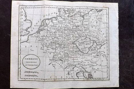
Sold2018FRAMED MAP, GERMANY NORTH OF THE MAYNEFramed map, "Germany, North of the Mayne", drawn and engraved for Thomson's New General Atlas, 1816, London engraved, hand colored highlights, sight approx: 20"h, 24.5"w, overall: 30"h, 34.5"w, 10.5lbSee Sold Price
Sold202118th C Large Handcolored Mercator Map GermanyLarge beautifully handcolored map of Braunswyck and Meydburg after Gerard Mercator circa 1640, this being an 18th century restike.. Printed at Amsterdam. Measures 23 x 19". Fine, reinforced central veSee Sold Price
Sold2024MAP, Germany, MunsterCentral Germany. Sebastian Munster, Francken Land in Germania..., from Cosmographei oder Beschreibung aller L?nder, 1556 (published). Hand Color. This woodblock map is oriented with north to the bottoSee Sold Price
Sold2022Barclay, James C1800 Hand Col Map. GermanyHand Colored Copper Engraved Map Published C1800 Halifax & Newcastle, England for "Barclay's Universal English Dictionary…" by James Barclay. Maps Engraved by Clerk, Milton and others. Paper Size: 1See Sold Price
Sold2019Barclay, James 1809 Hand Col Map. Germany & BohemiaHand Coloured Copper Engraved Map Published 1809, Leeds for "Barclay's Complete and Universal Dictionary of the English Language..." by the Rev. James Barclay. Folds as issued. Paper Size: 11 x 10 incSee Sold Price
Sold2021Wilkes, John 1805 Hand Col Map. GermanyFinely Hand Colored Copper Engraved Map Published 1796-1828 London for "Encyclopaedia Londinensis, or universal dictionary of arts, sciences and literature" by John Wilkes et al. Paper Size: 10.5 x 8.See Sold Price
Sold2022Barclay, James 1812 Hand Col Map. GermanyHand Colored Copper Engraved Map Published 1812-13 by Brightly & Childs, Bungay for "A Complete and Universal Dictionary of the English Language..." by the Rev. James Barclay. Paper Size: 10.5 x 8 incSee Sold Price
Sold2022Times Atlas 1895 Lot of 7 Maps. GermanyLithograph Map Published 1895, London for "The Times Atlas" Two with Centre fold as published. Paper Size: Up to 21 x 16 inch (53 x 41cm) A couple with centre fold splits. A few other minor faults inSee Sold Price
Sold2021Tallis, John (Pub) 1852 Map. GermanySteel Engraved Map with Original Outline Hand Color Published 1852-56 by John Tallis, London for "The Universal Pronouncing Dictionary" by Thomas Wright. Drawn & Engraved by John Rapkin. Centre fold aSee Sold Price
Sold2021Tallis, John (Pub) 1852 Map. GermanySteel Engraved Map with Original Outline Hand Color Published 1852-56 by John Tallis, London for "The Universal Pronouncing Dictionary" by Thomas Wright. Drawn & Engraved by John Rapkin. Centre fold aSee Sold Price
Sold2021Thomson, John (Pub) 1825 Map. GermanyCopper Engraved Map Published 1825 by John Thomson, Edinburgh for "The Edinburgh School Atlas" by N. R. Hewitt. Maps Engraved by Hewitt. Engraved Vignette in corner. Original Outline Hand Colour. RareSee Sold Price
Sold2023Thomson, John (Pub) 1825 Map. GermanyCopper Engraved Map Published 1825 by John Thomson, Edinburgh for "The Edinburgh School Atlas" by N. R. Hewitt. Maps Engraved by Hewitt. Original Outline Hand Colour. Rare. Paper Size: 10.5 x 8 inch (See Sold Price
Sold2021Guthrie, William 1806 Map. GermanyCopper Engraved Map Published 1806, London for "A New Geographical, Historical and Commercial Grammar..." by William Guthrie. The maps are by John Senex, Thomas Kitchin and others. Folds as issued. PaSee Sold Price
Sold2019Antique Map: Germany (Deutschland)Description: Antique Map: Germany (Deutschland), Holstein, Hanover, Mecklenburg, the Prussian States, Saxony. Antique steel engraved map with original outline hand coloring. Date of printing: 1844. CaSee Sold Price
Sold2021Guthrie, William 1798 Map. GermanyCopper Engraved Map Published 1798, London for "A New Geographical, Historical and Commercial Grammar..." by William Guthrie. The maps are by John Senex, Thomas Kitchin and others. Folds as issued. PaSee Sold Price
Sold2019Philip, George 1856 LG Hand Col Map. Germany North PartLarge Folio Lithograph Map Published Published 1856 by George Philip, Liverpool for "Philips' Commercial Atlas of the World" Paper Size: 26 x 21 inch (66 x 53cm) Light horizontal bend in centre. NeatlSee Sold Price
7 days LeftTrillium Antique Prints & Rare BooksKollner, Rare - Niagara Falls, Horseshoe Fall, from the Canada Side$200
150 Lots AwayTrillium Antique Prints & Rare BooksKollner, Rare - Fairmount Water-Works, Philadelphia, Pennsylvania$200(1 bid)
151 Lots AwayTrillium Antique Prints & Rare BooksKollner, Rare - Merchant's Exchange, Philadelphia, Pennsylvania$200(1 bid)
4 days LeftJasper52Large Antique French map GERMAN EMPIRE 1792 colored by POIRSON engraver Basset$170
3 days LeftJasper521799 Cary Map of Germany's Bavaria -- A New Map of the Circle of Bavaria, from the Latest$70
3 days LeftJasper52Rand, McNally & Co.'S Indexed Atlas of the World Map of Germany (Western Sheet). | (Eastern Sheet).$60
3 days LeftJasper521799 Cary Map of Germany's Franconia -- A New Map of the Circle of Franconia, from the Latest$70
3 days LeftJasper521801 Cary Map of Germany's lower Saxony -- A New Map of the Circle of Lower Saxony From the Latest$70
4 days LeftJasper52Tallis London Street View #45 Wellington St now Borough High Street (N) 1839 map$300
4 days LeftJasper52Tallis London Street View #60 Norton Folgate & Shoreditch High Street 1839 map$300
4 days LeftJasper52Tallis London Street View #63 Wardour Street (South) / Princes Street 1839 map$300
4 days LeftJasper52Tallis London Street View #44 St Martin's-Le-Grand, Aldersgate (South) 1839 map$300
4 days LeftJasper52Tallis London Street View #43 Holborn Viaduct (East), Smithfield Street 1839 map$300


![MAP, Germany, Braun & Hogenberg: Mainz & Wurzburg, Germany & Sion, Switzerland. Braun & Hogenberg, Moguntia, Germaniae Metropolis, ad Rheni... [on sheet with] Herbipolis, Comuniter Wirtzburg... [and] Sedunum, Primaria & Metropolitica](https://p1.liveauctioneers.com/6576/279721/147265449_1_x.jpg?height=310&quality=70&version=1677104593)

![MAP, Germany, Braun & Hogenberg: Flensburg & Itzehoe, Germany. Braun & Hogenberg, Flensburgum [on sheet with] Itzohoa, from Civitates Orbis Terrarum, Vol. IV, 1612 (published). Hand Color. This sheet includes bird's-eye views of the](https://p1.liveauctioneers.com/6576/338349/183246857_1_x.jpg?height=310&quality=70&version=1722455697)