Sold2016Map of Massachusetts from The Best InformationMap: The State of Massachusetts from The Best Information Maker: J. Low, Teibout Anderson Size: Octavo - 7.5 inches high x 9.25 inches wide Date: 1799 Engraved for a geography and bearing notation aloSee Sold Price
Sold2022Map of "The State of Massachusetts from the Best Information 1796"Map of "The State of Massachusetts from the Best Information 1796," hand colored copper engraving, published by J. Reid, New York from John Reid's American Atlas the second folio-sized atlas publishedSee Sold Price
Sold2019Map of the Kingdom of Holland,Title: Map of the Kingdom of Holland, Publication Date: 1795 Size: 8.3Height - 10.3Width Additional Information: from the best Authorities. Attractive encyclopedia (?) map. Detailed. While Holland isSee Sold Price
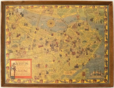
Sold20191950s Garfield Pictorial Map of Boston -- A Scott-MapTitle: 1950s Garfield Pictorial Map of Boston -- A Scott-Map of Boston Massachusetts Date: ca. 1950, Concord, MA Cartographer: A Scott Garfield Size: 20.7 x 27 in. Additional Information: A very attraSee Sold Price
Sold2019England And Wales from the Best Authorities.Title: England And Wales from the Best Authorities. Publication Date: 1790 Cartographer: ANONYMOUS Size: 7.5Height - 8.8Width Additional Information: Illustration map perhaps from Guthrie's Geography.See Sold Price
Sold2024Keith Haring - Ink on New York Map, Best Buddies, Inscribed, Signed, and DatedKEITH HARING Original Ink on New York Map Famous Image of Best Buddies Inscribed for Sean Signed and Dated Lower Side 26 1/2" x 25"See Sold Price
Sold2023Authorized Free Maps & Information Wood Map Rack w/Maps (TAC)rated 9, 21.5"x20"x3", the wood map display has good color, light wear, has a place for payment of one dime on the honor system, comes with a few road maps. TAC #018878See Sold Price
Sold2020Caspian Sea. Detailed map. Best to dateTitle: Caspian Sea. Detailed map. Best to date Description: By. Herman Moll. From. Atlas minor. Published. London. Date/ Period: 1729-1736 Materials: Copperplate engraved. Dimensions: 13 1/2 x 9 “ RSee Sold Price
Sold20231810 Modern Geography America MAP + World Map Massachusetts Elijah Parish1810 Modern Geography America MAP + World Map Massachusetts Elijah Parish Elijah Parishs “New System of Modern Geography” is an early 19th-century American geography textbook. Published inSee Sold Price
Sold2018North Atlantic Airlines Route Map Information Booklet CNorth Atlantic Airlines Route Map Information Booklet Circa 1950sSee Sold Price
Sold2024Nine United Air Lines Paper Items - Travel Brochures, Guides, Maps, Information Packet, Flight Log,An assorted collection of paper for United Air Lines including a 1946 Maps of the Main Line Airway with 35 pages of information, maps, illustrations, and photographs. 1951 Air Maps of Main Line AirwaySee Sold Price
Sold2023Sylvester, W/C/P "View On The Beach"Harry Elliott Sylvester (Am. 1860-1921) active and lived in Massachusetts. Information verso pertaining to another work "April 21, 1887". Frame size: 13 1/2" high, 17 1/4" wide. Foxing, toning, acid sSee Sold Price
Sold2018Tanner: Antique Map of Massachusetts & Rhode IslandTitle/Content of Map: Massachusetts & Rhode Island with insert of Boston by Tanner Date Printed: 1843 Cartographer: H.C. Tanner Material/Medium: Paper Size: 17" x 14" Hand colored engraved Map based oSee Sold Price
Sold2024Map States Of Massachusetts, Connecticut & Rhode Island Andrus & Judd 1832Andrus & Judd 1832 Map Massachusetts, Connecticut and RI. Andrus & Judd's map of the region, hand colored by counties. Includes towns, roads, existing and proposed canals, railroad and proposed railroSee Sold Price
Sold20221833 Map1833 Map "MASSACHUSETTS / CONNECTICUT / RHODE ISLAND….Published H.P. Sumner & Co. Hartford Ct. / 1833". Sight 15" x 20", overall 22 1/2" x 27".See Sold Price
Sold2022CAT POTTERY BANK LIKELY NC CIRCA 2000-2010Based upon the collection of the consignor, this is the best information on this particular we could determine. Turned little figural and the owner definitely was a cat lover we know because of severaSee Sold Price
Sold2017Massachusetts, Connecticut and Rhode Island insert ofTitle/Content of Map: Massachusetts, Connecticut and Rhode Island insert of Bostn Date Printed: 1877 Cartographer: F.A. Gray Material/Medium: Paper Size: 25 1/2" x 16" Map is set in matting. May be reSee Sold Price
Sold2019Massachusetts, Connecticut, Rhode IsTitle/Content of Map: Massachusetts, Connecticut, Rhode Is Date: 1863 Cartographer: By Johnson & Ward. From, Johnson’s New Illustrated Family Atlas Size: 18x26 1/2” Provenance: New York Hand colorSee Sold Price
Sold2021Massachusetts 1898Title/Content of Map: Massachusetts 1898 Date Printed: 1898 Material/Medium: Paper Size: approx 11x14 inches Additional Info: Rand McNally & Co. Reserve: $30.00 Shipping: Domestic: Flat-rate of $15.00See Sold Price
Sold2018Colton: Antique Map of Massachusetts & Rhode IslandTitle/Content of Map: Massachusetts & Rhode Island by Colton Date Printed: Cartographer: J.H. Colton Size: 14" x 17" Material/Medium: Paper Provenance: New York From 'Colton's General Atlas'. Hand colSee Sold Price
Sold2024Canada Related EphemeraLarge lot includes travel brochures, maps, information and much more from far and wide.See Sold Price
Sold20164 Maps: Bradford (1838): Mass., CT, NJ, Boston.[United States/Northeast] 4 Maps. ++ MASSACHUSETTS. ++ BOSTON. ++ CONNECTICUT. ++ NEW JERSEY. ++ Maps 10, 11, 13, and 16 from T. G. Bradford, “An Illustrated Atlas, Geographical, Statistical, And HiSee Sold Price
Sold2016"Osgood Carleton", Map Of MassachusettsC. 1801-1802 "Osgood Carleton", map of Massachusetts. Sight 30 3/4" x 45 3/4".See Sold Price
Sold2018Hand drawn and colored map of Massachusetts includingHand drawn and colored map of Massachusetts including Cape Cod, Plymouth, Kingston, Duxbury, etc. professionally matted and framed. sight size: 15 1/2" x 19 1/2" Provenance: Property from Credit SuiSee Sold Price
Oct 18Rail & Road AuctionsEarly Northern Pacific Railroad and Oregon Railway & Navigation Co. Promotional Brochure w/ Map$30
Oct 18Rail & Road Auctions1878 Maps of the New and Popular St. Louis and Texas Short Line Railroad Color Lithograph$40(1 bid)
Oct 18Rail & Road AuctionsFour Early Railroad Timetables and Travel Brochures - Grand Rapids and Indiana, Chicago Milwaukee &$40
2 days LeftJasper52Being a map of Hollywood, from the best surveys of the time. GRIEVE 1926 (1960s)$1,100
2 days LeftJasper52Rhode Island, part of Connecticut & Massachusetts shewing… LODGE 1780 old map$500
2 days LeftJasper52A New and accurate Map of New Jersey… Universal Magazine 1780 old antique$650
Oct 18Rail & Road AuctionsLima - Hamilton Chicago River & Indiana / NYC #8406 1200 HP Switcher Builders Plate$200
Oct 12JM Hobby Supply and Railroad Artifact AuctionsChicago Rock Island and Pacific RR Employee Timetable #36, 11/7/1915$10
5 days LeftTrillium Antique Prints & Rare BooksVan der Aa - Map of the Middle East: Persia, Arabia (Explorer: Robert Coverte)$75
5 days LeftTrillium Antique Prints & Rare BooksVan der Aa - Map of India: Hindustan (Explorer: Sir William Methold, first European to visit the$75
5 days LeftTrillium Antique Prints & Rare BooksVan der Aa - Map of Central America: Yucatan Peninsula (Explorer: Gil Gonzalez Davila)$75
5 days LeftTrillium Antique Prints & Rare BooksVan der Aa - Map of Southern Atlantic Ocean: South America, part of North America, Europe, Africa$75
Oct 26Sofe Design AuctionsRare Map with the marking of Sea of Korea/East Sea by Jacques Nicolas Bellin ? 18th Century.$100


![4 Maps: Bradford (1838): Mass., CT, NJ, Boston.: [United States/Northeast] 4 Maps. ++ MASSACHUSETTS. ++ BOSTON. ++ CONNECTICUT. ++ NEW JERSEY. ++ Maps 10, 11, 13, and 16 from T. G. Bradford, “An Illustrated Atlas, Geographical, Statistical, And Hi](https://p1.liveauctioneers.com/179/85723/44107996_1_x.jpg?height=310&quality=70&version=1457209040)


