Sold2022Austria,Title: Austria, Date: 1875 Cartographer: DOWER, JOHN Publisher: H. H. HARDESTY & CO. Description: "By J. Dower, F.R.G.S." Some topography. Map reprinted from The (London) Weekly Dispatch atlas and useSee Sold Price
Sold2019India Hindostan.Title: India Hindostan. Publication Date: 1875 Cartographer: JOHNSTON, KEITH Publisher: H. H. HARDESTY & CO. Size: 23.5Height - 12Width Double page map reprinted from The (London) Weekly Dispatch atlaSee Sold Price
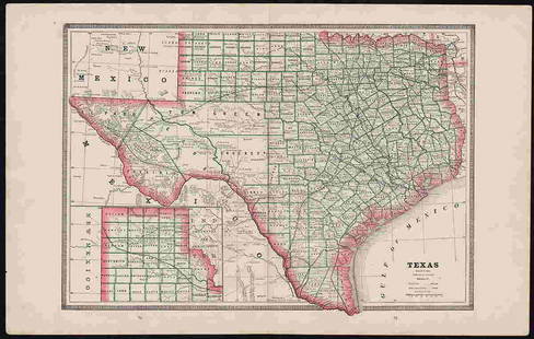
Sold2017Scarce Map of Texas, New Mexico and ArizonaItem: Scarce Map of Texas, New Mexico and Arizona Description: Scarce Map of Texas, New Mexico and Arizona from Wallings's 1868 State Atlas of Ohio Dimensions: 14.25 x 26.25 Please note that this lotSee Sold Price
Sold2018South America C1860-1930's Lot of 11 MapsLot of 11 Lithographed Maps, mostly large size. Examples by Rand-Mcnally, Instituto Geografico Militar, Weller/Weekly Dispatch, RGS, George Philip, Times Atlas/Bartholomew and others. Paper Size: Up tSee Sold Price
Sold2022Weekly Dispatch C1860 Lot of 6 Large British MapsIncl Lake District, Worcestershire/Gloucestershire, Cumberland/Westmoreland, Durham, Wiltshire, and Bedforshire. Lithograph Maps Published C1860, London for "The Dispatch Atlas" and/or "The Weekly DisSee Sold Price
Sold2019Weller, Edward C1860 Lot of 7 UK County MapsIncl Northants, Worcester, Lancashire, Monmouth, Hereford, and Somerset. Lithograph Maps Published C1860, London for "The Dispatch Atlas" and/or "The Weekly Dispatch" by Edward Weller and others. InclSee Sold Price
Sold20181863 Dispatch Atlas Map of Kent -- The Watering PlacesTitle/Content of Map: 1863 Dispatch Atlas Map of Kent -- The Watering Places of Kent Date: 1863, London Cartographer: Dispatch Atlas Size: 16.8 X 11.8 in. This is a handsome and highly detailed map ofSee Sold Price
Sold20181863 Dispatch Atlas Map of Kent -- The Watering PlacesTitle/Content of Map: 1863 Dispatch Atlas Map of Kent -- The Watering Places of Kent Date Printed: 1863, London Cartographer: Dispatch Atlas Size: 16.8 X 11.8 in. This is a handsome and highly detaileSee Sold Price
Sold2017Gray: Antique Map of Texas verso Arkansas, 1873Map: 1873 Gray's Map of Texas verso Arkansas -- Gray's Atlas Map of Texas; Gray's Atlas Map of Arkansas Cartographer: F Gray Year / Place: 1873, Philadelphia Map Dimensions: 11.8 X 15 in. Condition: VSee Sold Price
Sold2017Mitchell: Antique Map of Texas from 1851 atlas1846 Mitchell Map of Texas from 1851 atlas. This map features an early rendering of the final borders of the new State of Texas. This is from the series that was the first to name Dallas. Indian tribeSee Sold Price
Sold2017Mitchell: Map of Texas from 1851 Atlas1846 Mitchell Map of Texas from 1851 atlas. 8 x 10.5 inches. This map features an early rendering of the final borders of the new State of Texas. This is from the series that was the first to name DalSee Sold Price
Sold20191892 Watson/Cram Map of Texas [verso] Indian TerritoryTitle/Content of Map: 1892 Watson/Cram Map of Texas [verso] Indian Territory [verso] Arkansas -- Watson's Atlas Map of Texas [verso] Watson's Atlas Map of Indiand Ty. [verso] Watson's Atlas Map of ArkSee Sold Price
Sold20171855 1st Ed. Texas map from Colton’s Atlas of the WorldItem: 1855 1st Ed. Texas map from Colton’s Atlas of the World Description: Counties current to 1854 making this the uncommon and desirable first edition (Tarrant county appears, but not the 1855 addSee Sold Price
Sold2017Gray's Atlas Map of Texas, 1873Map: Gray's Atlas Map of Texas Cartographer: Gray Illustrator: Gray, O. W. Publisher: Stedman, Brown & Lyon Date: 1873 Size: 12.5 x 15.25 inches Fully hand colored by counties. Counties extend in theSee Sold Price
2023Rand, McNally New Commercial Atlas Map of TexasDescriptionTitle: Rand, McNally New Commercial Atlas Map of TexasPublication Date: c1920-1925Cartographer: RAND, MCNALLY & CO.Publisher: RAND, MCNALLY & CO.Height: 26Width: 37Atlas map to twice naturaSee Sold Price
Sold2023Rand, McNally New Commercial Atlas Map of TexasTitle: Rand, McNally New Commercial Atlas Map of TexasPublication Date: c1920-1925Cartographer: RAND, MCNALLY & CO.Publisher: RAND, MCNALLY & CO.Height: 26Width: 37Atlas map to twice natural size. RaiSee Sold Price
Sold2017Rand McNally: Map of Texas from Jones & Hamilton AtlasEarly Rand McNally vertical format Texas map from scarce 1876 Jones & Hamilton atlas. Large and uncommon McNally vertical format map of Texas from the scarce 1876 Jones & Hamilton Historical Atlas ofSee Sold Price
Sold2023Highly collectible 1860 RR map of Texas, S. A. Mitchell, Jr.One of the most attractive atlas maps of Texas to appear in the mid-19th century. This authentic antique map (160 years old) was published when the Civil War was at its height. It shows the region froSee Sold Price
Sold20221875 Gray's New Map of Texas - 1st ed.Large and impressive hand-colored map of Texas from Gray’s National Atlas. Full title: “Gray’s New Map of Texas and the Indian Territory.” Created by Frank Gray, the map hasSee Sold Price
Sold2022Exceptional 1864 RR map of Texas, S. A. Mitchell, Jr.One of the most attractive atlas maps of Texas to appear in the mid-19th century. This nearly 160-year-old map--published during the height of the Civil War--shows the region from western New Mexico tSee Sold Price
Sold2019Egypt & Arabia 19th Cent. Lot of 5 MapsLot of 4 19th Cent Lithographed and Engraved Maps. Examples by SDUK, Weller/Weekly Dispatch, William Collins, and Johnston. Together with a large 20th Cent. Admiralty Chart of the Red Sea, published 1See Sold Price
Sold2023RR map of Arizona from scarce 1898 Cram’s Atlas.Large and dramatic double-page map of Arizona naming and showing all rail lines in the state. Every railroad line is named, numbered, and color-coded by a legend on the map. From the very scarce Cram�See Sold Price
2021Bradford's Map of Texas 1835/36"Bradford's Map of Texas, 1st Separate Map of Texas to Appear in an Atlas" by Thomas G. Bradford, copper engraving with hand-colored outlines, published Boston, 1835/1836, together with accompanying aSee Sold Price
Sold2022Clean 1883 RR map of Texas, Geo. F. CramInteresting cerographic map of Texas from Cram’s Unrivaled Family Atlas of the World. Predates subdivision of Tom Green, Pecos, Crockett and Presidio Counties. Shows rail system throughout statSee Sold Price
4 days LeftSchilb Antiquarian Rare Books1848 Emory Military Reconnaissance 1ed California MAP Indians Texas New Mexico$56(7 bids)
Jul 14Schilb Antiquarian Rare Books1939 John Ogilby Britannia Atlas MAPS 1ed 1675 facsim England Wales COLOR Road$1
5 hrs LeftJasper52PACIFIC OCEAN showing British French Dutch US territory. US Philippines 1947 map$20
5 hrs LeftJasper52Pacific Islands. Polynesia Micronesia Melanesia. Fiji Caroline &c TIMES 1895 map$20
5 hrs LeftJasper52South Pacific Ocean. Polynesia "Dangerous Archipelago" Galapagos LIZARS 1842 map$40
5 hrs LeftJasper52Océanique. Archipel de Mendana #34. Marquesas Polynesia. VANDERMAELEN 1827 map$60
5 hrs LeftJasper52Océanique. Partie des Iles Carolines #9. Yap Micronesia. VANDERMAELEN 1827 map$55
5 hrs LeftJasper52Oceania or Islands in the Pacific Ocean. Polynesia Australasia SWANSTON 1860 map$60
5 hrs LeftJasper52Océanique. Partie des Iles Carolines #9. Yap Micronesia. VANDERMAELEN 1827 map$55
5 hrs LeftJasper52Océanique. Partie des Iles Salomon #33. Solomon Islands. VANDERMAELEN 1827 map$65
5 hrs LeftJasper52Océanique. Archipel des Nouvelle Hébrides #39. Vanuatu. VANDERMAELEN 1827 map$85
5 hrs LeftJasper52Océanique. Iles Mariannes #5. Mariana Islands Guam Saipan. VANDERMAELEN 1827 map$100
5 hrs LeftJasper52NEW CALEDONIA. Nouvelle Caledonie. Loyalty Islands/Îles Loyauté. Nouméa 1929 map$40


![1892 Watson/Cram Map of Texas [verso] Indian Territory: Title/Content of Map: 1892 Watson/Cram Map of Texas [verso] Indian Territory [verso] Arkansas -- Watson's Atlas Map of Texas [verso] Watson's Atlas Map of Indiand Ty. [verso] Watson's Atlas Map of Ark](https://p1.liveauctioneers.com/5584/133765/67935052_1_x.jpg?height=310&quality=70&version=1546475054)