Sold2022Exceptional 1864 RR map of Texas, S. A. Mitchell, Jr.One of the most attractive atlas maps of Texas to appear in the mid-19th century. This nearly 160-year-old map--published during the height of the Civil War--shows the region from western New Mexico tSee Sold Price
Sold2023Highly collectible 1860 RR map of Texas, S. A. Mitchell, Jr.One of the most attractive atlas maps of Texas to appear in the mid-19th century. This authentic antique map (160 years old) was published when the Civil War was at its height. It shows the region froSee Sold Price
2018Mitchell: Antique Map of Palestine, 18641864 hand-colored map of Palestine by S. Augustus Mitchell. A beautiful example of S. A. Mitchell Jr.'s 1864 map of Palestine, Israel or the Holy Land. Updated from the 1860 variant with new details,See Sold Price
Sold20171864 hand-colored map of Palestine by S. AugustusA beautiful example of S. A. Mitchell Jr.'s 1864 map of Palestine, Israel or the Holy Land. Updated from the 1860 variant with new details, an inset of Jerusalem, and a new 1864 copyright. Includes boSee Sold Price
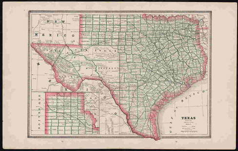
Sold2018County Map of Texas.Reserve Reduced! Title: County Map of Texas. Publication Date: 1861 Cartographer: MITCHELL, SAMUEL AUGUSTUS (JR.) Publisher: S. Augustus Mitchell, Jr. Size: 10.75 X 13.25 Map 29 from Mitchell's New GeSee Sold Price
Sold2018County Map of Texas.Title/Content of Map: County Map of Texas. Date Printed: 1870 Cartographer: MITCHELL, SAMUEL AUGUSTUS (JR.) Material/Medium: S. Augustus Mitchell, Jr. Size: 9.25X12 Inset of Galveston Bay and VicinitySee Sold Price
Sold2022SAMUEL AUGUSTUS MITCHELL JR., AN AMERICAN CIVIL WAR ERASAMUEL AUGUSTUS MITCHELL JR., AN AMERICAN CIVIL WAR ERA MAP, "County Map of Texas," CIRCA 1863, hand-colored lithograph on paper with profusely floral and fruit border, plate 34. from Mitchell's New GSee Sold Price
Sold2018County Map of Texas, S. A. Mitchell, 1860Reserve Reduced! Authentic handcolored map of Texas with 1860 date but from Mitchell’s New General Atlas published 1864 by S. Augustus Mitchell. Detailed early map of Texas, immediately prior to theSee Sold Price
Sold2017Map of U.S., Mexico, & GuatemalaMap of the U.S. and Texas & Mexico and Guatemala by S. Augustus Mitchell Jr. 1840 Size: 17.5 x 11.75 in Please note that this lot has a confidential reserve. When you leave a bid in advance of the aucSee Sold Price
Sold2022Plan of the City of Washington, D. C., Mitchell 1864One of the nicer maps of the city, found in S. A. Mitchell, Jr’s New General Atlas. This map is a relic of the Civil War, as it was published when the war was in full swing. Beautifully coloredSee Sold Price
Sold2018[ATLASES].* [ATLASES]. Four editions of Mitchell's New General Atlas, Containing Maps of the Various Countries of the World, Plans of Cities, Etc. Philadelphia: S. Augustus Mitchell, Jr., 1861 - 1864 - 1878 - 1See Sold Price
Sold2022Asher & Adams' unique RR map of Texas, 1871County map of East Texas depicted in the unique Asher & Adams’ style, without roads to highlight the presence of railroads. Extends from Louisiana west to beyond San Antonio and features the raSee Sold Price
Sold2022Clean 1883 RR map of Texas, Geo. F. CramInteresting cerographic map of Texas from Cram’s Unrivaled Family Atlas of the World. Predates subdivision of Tom Green, Pecos, Crockett and Presidio Counties. Shows rail system throughout statSee Sold Price
Sold20201852 HAND TINTED OLD ANTIQUE MAP of TEXAS, MITCHELL s1852 HAND TINTED OLD ANTIQUE MAP of TEXAS, MITCHELL s SCHOOL & FAMILY GEOGRAPHY 1852 Antique Map by S. Augustus Mitchell of Pennsylvania. ??No. 13 - MAP OF THE STATE OF TEXAS. Engraved to Illustrate MSee Sold Price
Sold2021Uncommon map of Texas – Mitchell/Butler 1868Title: Uncommon map of Texas – Mitchell/Butler 1868 Description: "Copperplate engraved map from Mitchell’s New Reference Atlas, a somewhat elusive school geography. Published by E. H. Butler in 18See Sold Price
Sold2023Rare 1st state of Florida map from 1st printing of 1860 atlasFirst edition, first state of S. A. Mitchell Jr.'s County Map of Florida/County Map of South Carolina. Maps from Mitchell Jr’s first printing of his first New General Atlas are distinguished bySee Sold Price
Sold2022Exceptional map of Johnson's Texas, 1866Authentic and impressive vintage map of Texas. A highly desirable map that details the state in full. Shows the elevated Table Lands, the U. S. Mail Route, the Staked Plain (El Llando Estadado), numerSee Sold Price
Sold20231864 Johnson Map of Texas -- Johnson's New Map of the State of TexasTitle: 1864 Johnson Map of Texas -- Johnson's New Map of the State of Texas Cartographer: Johnson & Ward Year / Place: 1864, New York Map Dimension (in.): 16.7 X 24.5 in. Thisis a double page, superbSee Sold Price
Sold20191864 Johnson Map of Texas -- Johnson's New Map of theTitle/Content of Map: 1864 Johnson Map of Texas -- Johnson's New Map of the State of Texas Date: 1864, New York Cartographer: Johnson & Ward Size: 16.7 X 24.5 in. This a double page, large, quite attrSee Sold Price
Sold2024Scarce 1st ed./1st printing of Mitchell map of Mexico/W. IndiesAuthentic first edition/first printing of Samuel A. Mitchell Jr’s Map of Mexico, Central America and the West Indies, with plate number just above title, indicating the rare first state of this map.See Sold Price
Sold2023MAPS: MITCHELL NEW ORLEANS, FLORIDA, ARKANSASUnframed map, Samuel Augustus Mitchell, Jr., copyright 1882, depicting "Plan of New Orleans, "Country Map of Florida" on one side, "County Map of the States of Arkansas, Mississippi and Louisiana" onSee Sold Price
Sold2017Mitchell: Map of Persia, 18621862 Mitchell Map of Persia. 10.625 x 13.25. Map of Persia, Turkey in Asia, Afghanistan, Beloochistan. Very attractive example of S. A. Mitchell Jr.'s map of this region. Covers the modern day nationsSee Sold Price
Sold2023Excellent 1860 map of Baltimore by Samuel A. Mitchell, Jr.Nice example of Samuel Augustus Mitchell Jr’s map of Baltimore with the vivid outline hand coloring that sets this edition off from other editions. Shows wonderful detail at the street level, inSee Sold Price
Sold20231856 Texas Map by MitchellDescriptionTitle: 1856 Texas Map by MitchellDate/Period: 1856Materials: Hand colored steel engravingSize: 11” x 9”br>Discover Texas as it was in 1856 with this important early map by MitchSee Sold Price
May 16Potter & Potter AuctionsSTORM, Mark. Official Texas Brags Map of North America. 194...$200(1 bid)
1 day LeftMerrill's Auctioneers and AppraisersAaron Willard, Jr Boston Gilt Banjo Clock$2,100(5 bids)
2 days LeftTrillium Antique Prints & Rare BooksMitchell's A New Universal Atlas.. - Volume with 73 Maps$1,000(1 bid)
4 days LeftCurated Gallery AuctionsDawson Dawson-Watson (1864-1939) Antique American Impressionist Texas Seascape Original Painting$10(1 bid)
8 hrs LeftMynt AuctionsNolan Ryan HOF Autographed/Inscr Mitchell & Ness Navy Jersey Rangers JSA 179440$10
May 15Fleischer's Auctions[Gettysburg] Sword & Journal of Confederate Officer (41st Virginia)$1,800(8 bids)


![[ATLASES].: * [ATLASES]. Four editions of Mitchell's New General Atlas, Containing Maps of the Various Countries of the World, Plans of Cities, Etc. Philadelphia: S. Augustus Mitchell, Jr., 1861 - 1864 - 1878 - 1](https://p1.liveauctioneers.com/197/119933/61100820_1_x.jpg?height=310&quality=70&version=1522758048)


![[CIVIL WAR] 2nd Texas Cav. 1864 ALS (1 of 3)](https://p1.liveauctioneers.com/7226/322253/173251511_1_x.jpg?height=282&quality=70&version=1710004847)


![[Gettysburg] Sword & Journal of Confederate Officer (41st Virginia) (1 of 11)](https://p1.liveauctioneers.com/7226/325455/175169156_1_x.jpg?height=282&quality=70&version=1712370394)


![[CIVIL WAR] Confederate POW Letters (2) (1 of 1)](https://p1.liveauctioneers.com/7226/325455/175169081_1_x.jpg?height=282&quality=70&version=1712370394)
