Sold20211853 Geological Map of Passes by St. Gabriel Mountains,Title: 1853 Geological Map of Passes by St. Gabriel Mountains, CA -- Geological Map of the Tejon Pass & Canada de las Unas Including the Pass of San Franciscoquito & Williamson's Pass Cartographer: WSee Sold Price
Sold20171853 Geological Plan for Pacific RRItem: 1853 Geological Plan for Pacific RR Date: 1853 Geological Plan for Pacific RR San Francisco to Sierra Nevada -- Geological Section of the Coast Mountains and Sierra Nevada. Very nice geologicalSee Sold Price
Sold2018Geological Map of San Francisco Bay Area, 1853Title/Content of Map: 1853 Geological Map of San Francisco Bay Area for the Pacific Rail Road -- Geological Map of the Vicinity of San Francisco Date Printed: 1853, Philadelphia Cartographer: W BlakeSee Sold Price
Sold2023Williamson, Lieut. R. S. 1856 Map. California - Tejon Pass & Canada de las Uvas"Geological Map of the Tejon Pass & Canada de las Uvas and the Vicinity. Including the Pass of San Francisco & Williamsons Pass"Lithograph Map Published 1853-61, Washington for "Reports of explorationSee Sold Price
Sold2023Williamson, Lieut. R. S. 1856 LG Chart. California - Bernadino Pass, San Bernardino, Colorado Desert"Geological Sections of the Bernadino Pass" Lithograph Map Published 1853-61, Washington for "Reports of explorations and surveys, to ascertain the most practicable and economical route for a railroadSee Sold Price
Sold2023Williamson, Lieut. R. S. 1856 LG Chart. California - Bernardino Sierra, San Pedro"Geological Section of the Bernardino Sierra from the Great Basin to the Pacific ocean at San Pedro" by William P. Blake. Lithograph Map Published 1853-61, Washington for "Reports of explorations andSee Sold Price
Sold20221853 Geological Plan for Pacific RR from Colorado River to the Pacific Ocean -- Geological SectionTitle: 1853 Geological Plan for Pacific RR from Colorado River to the Pacific Ocean -- Geological Section from the Colorado River to the Pacific Ocean Cartographer: W Blake / R Williamson Year / PlaceSee Sold Price
Sold2017Geological Plan for Pacific Railroad, 1856Title/Content of Map: 1856 Geological Plan for Pacific RR along the Tejon Ravine / Sierra Nevada -- Geological Section Along the Tejon Ravine ... from the Tulare Valley and The Tejon Depot Camp to TahSee Sold Price
Sold2018Antique Geological Plan for Pacific RR Rio Grande, 1856Title/Content of Map: 1856 Geological Plan for Pacific RR of Rio Grande due NorthWest -- Geological Plan & Section from the Rio Grande to the Pimas Villages… No. 2 Date Printed: 1856 Washington DC CSee Sold Price
Sold20191853-4 Botanical Profile Map for Pacific RR Through NewTitle/Content of Map: 1853-4 Botanical Profile Map for Pacific RR Through New Mexico and Parts of Arizona -- Botanical Profile Representing the Forest Trees Along the Route Explored by Lieut. A. W. WhSee Sold Price
Sold2022The Road of a Thousand Wonders Book-Southern Pacific RRThis book is the first edition of The Road of a Thousand Wonders, published in 1907 for the passenger department of the Southern Pacific Railroad in San Francisco, CA. The book has well over 100 colorSee Sold Price
Sold2023Williamson, Lieut. R. S. 1856 Map. Vicinity of San Francisco California"Geological Map of the Vicinity of San Francisco" by William P. Blake. Lithograph Map Published 1853-61, Washington for "Reports of explorations and surveys, to ascertain the most practicable and econSee Sold Price
Sold2023Williamson, Lieut. R. S. 1856 HC Map. San Diego & Colorado River California"Geological Map of the Country Between San Diego and the Colorado River California" By W. P. Blake. Hand Colored Lithograph Map Published 1853-61, Washington for "Reports of explorations and surveys,See Sold Price
Sold2021Railroad Lock Keys (4), CA - Napa Area RR LinesID Marks: SFN&C (San Francisco Napa & Calistoga Railroad); SFNVRR (San Francisco Napa Valley RR); SFNVRR (San Francisco Napa Valley RR) ;NWPRR (Northwestern Pacific RR) (Windsor - Sonoma - Marin)Date:See Sold Price
Sold2017Geological Plan For Pacific Rail Road Surveys Map 18561855-6 Geological Plan For Pacific Rail Road Surveys -- Geological Plan Of The Coastal Range Of California From San Francisco To Los Angeles - No. 1. J Parke / T Antisell, 1856-7 Washington DC, 16.8 XSee Sold Price
Sold2023Williamson, Lieut. R. S. 1856 LG Chart. California - Colorado River to the Pacific Ocean"Geological Section from the Colorado River to the Pacific Ocean" by William P. Blake. Lithograph Map Published 1853-61, Washington for "Reports of explorations and surveys, to ascertain the most pracSee Sold Price
Sold2022YONGZHENG BLUE & WHITE UNDERGLAZE RED CELESTIAL VASEPROVENANCE: From The Estate of Kee Chiu, Chinese Immigrant Entrepreneurs, Private Collectors. Acquired from PACIFIC CURIO SHOP, 2734 Taylor ST, San Francisco, CA; Importer of all kind Asiatic Goods. FSee Sold Price
Sold2017Pictorial map of Southern CaliforniaHeading: (California) Author: Putnam, Claude G. Title: Southern California's Sunshine Empire and Golden Coast (wrapper title) Place Published: San Bernardino, CA Publisher:Southern California TouristSee Sold Price
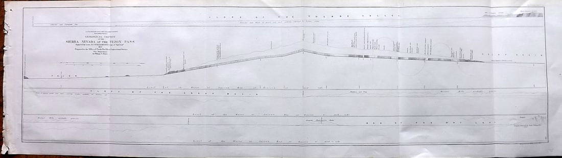
Sold2023Williamson, Lieut. R. S. 1856 LG Chart. California - Sierra Nevada & Tejon Pass"Goelogical Section of the Sierra Nevada at the Tejon Pass" by R. S. Williamson. Lithograph Map Published 1853-61, Washington for "Reports of explorations and surveys, to ascertain the most practicablSee Sold Price
Sold2020Cadastral map of Crestline, San Bernardino Co., Cal.Heading: (California - San Bernardino County) Author: Title: Valley of Enchantment Mutual Water Co. Place Published: Crestline, CA Publisher: Date Published: c.1930 Description:See Sold Price
Sold2022Pamphlet on Cal. oil fields w/ color map 1865Heading: Author: Silliman, Benjamin Title: Professor Silliman's Report Upon The Oil Property Of The Pacific Coast Petroleum Company, Of New -York, Situated In San Luis Obispo County, California. To wSee Sold Price
Sold2021A UNION PACIFIC RR SILVER PLATED DINING CAR BUD VASEThe silver plated bud vase with Winged Streamliner Zephyr logo engraved on the foot, signed U.P.R.R. on the base and marked International Silver, number 05043. Measures 6.75 inches. We happily provideSee Sold Price
Sold2022Color map of San Francisco Chinatown 1885Heading: -1885 Author: Title: Official Map of Chinatown in San Francisco Place Published: San Francisco Publisher: Date Published: 1885 Description: Color lithographed map. 21.1See Sold Price
Sold2022Pedro Antonio Fresquis, San Jose, ca. 1790Pedro Antonio Fresquis(Truchas, 1749 - 1831)San Jose, ca. 1790carved wood, gesso, pigment24 x 11 x 7 1/2 in. (60.96 x 27.94 x 19.05 cm.) The Paul Rhetts Collection, New MexicoExhibited:&quSee Sold Price
May 09Rail & Road AuctionsSeven Midwestern Railroad 1912 Annual Passes - Michigan Central, Pere Marquette, Missouri Pacific,$30
5 days LeftJasper521850 Sacramento and San Joaquin Rivers Chart -- Chart of Suisun & Vallejo Bays with the Confluence$200
5 days LeftThe Benefit Shop Foundation Inc.San Pacific International Gilt Elephant Bookends$25(3 bids)
May 18Alice Callahan Auction HouseSPI San Pacific International Crane Bird Herons Egret -Bronze Sculpture - 20"$75(2 bids)
May 10Crescent City Auction GallerySPI (San Pacific International), Patinated Bronze of King Triton, 20th c., Overall- H.- 29 1/4 in.,$325(1 bid)
May 04BucklinRyden, Mark [SIGNED]; Anima Mundi: The Art of Mark Ryden [BOXED DELUXE EDITION WITH SIGNED PRIN$240(1 bid)
May 07John Moran Auctioneers, Inc.Albert Thomas DeRome (1878-1950), "Dr. David Anderson Cottage, Carmel," 1937$300
May 07John Moran Auctioneers, Inc.George Spangenberg (1907-1964), "Valley of the Old Women," circa 1940s$250


![Ryden, Mark [SIGNED]; Anima Mundi: The Art of Mark Ryden [BOXED DELUXE EDITION WITH SIGNED PRIN (1 of 11)](https://p1.liveauctioneers.com/8658/325945/175541616_1_x.jpg?height=282&quality=70&version=1712964944)


