Sold2023Williamson, Lieut. R. S. 1856 LG Chart. California - Colorado River to the Pacific Ocean"Geological Section from the Colorado River to the Pacific Ocean" by William P. Blake. Lithograph Map Published 1853-61, Washington for "Reports of explorations and surveys, to ascertain the most pracSee Sold Price
Sold2023Williamson, Lieut. R. S. 1856 LG Chart. California - Bernardino Sierra, San Pedro"Geological Section of the Bernardino Sierra from the Great Basin to the Pacific ocean at San Pedro" by William P. Blake. Lithograph Map Published 1853-61, Washington for "Reports of explorations andSee Sold Price
Sold2023Williamson, Lieut. R. S. 1856 LG Chart. California - Colorado Desert"Sections of the Colorado Desert" Explored by Lieut R. S. Williamson. Lithograph Map Published 1853-61, Washington for "Reports of explorations and surveys, to ascertain the most practicable and econoSee Sold Price
Sold2023Williamson, Lieut. R. S. 1856 LG Chart. California - Bernadino Pass, San Bernardino, Colorado Desert"Geological Sections of the Bernadino Pass" Lithograph Map Published 1853-61, Washington for "Reports of explorations and surveys, to ascertain the most practicable and economical route for a railroadSee Sold Price
Sold2023Williamson, Lieut. R. S. 1856 LG Chart. California - Sierra Nevada, Tulare Valley etc"Geological Section along the Tejon Ravine from the Tulare Valley and the Tejon Depot Camp to Taheechaypah Prairie" "Geological Section of the Sierra Nevada at the Canada de las Uvas" by William P. BlSee Sold Price
Sold2023Williamson, Lieut. R. S. 1856 LG Chart. California - Coast Mountains & Sierra Nevada"Geological Section of the Coast Mountains and Sierra Nevada" by W. P. Blake. Lithograph Map Published 1853-61, Washington for "Reports of explorations and surveys, to ascertain the most practicable aSee Sold Price
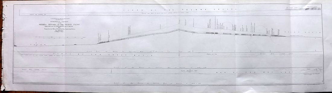
Sold2023Williamson, Lieut. R. S. 1856 LG Chart. California - Sierra Nevada & Tejon Pass"Goelogical Section of the Sierra Nevada at the Tejon Pass" by R. S. Williamson. Lithograph Map Published 1853-61, Washington for "Reports of explorations and surveys, to ascertain the most practicablSee Sold Price
Sold2023Williamson, Lieut. R. S. 1856 HC Map. San Diego & Colorado River California"Geological Map of the Country Between San Diego and the Colorado River California" By W. P. Blake. Hand Colored Lithograph Map Published 1853-61, Washington for "Reports of explorations and surveys,See Sold Price
Sold2019Report of Explorations in California for RailroadWilliamson, R.S. Report of Explorations in California for Railroad Routes from the Mississippi River to the Pacific Ocean. Washington: A. O. P. Nicholson, 1856. Volume V. Half calf over marbled boardsSee Sold Price
Sold2023Williamson, Lieut. R. S. 1856 LG HC Map. California - First Geological Map"Geological Map of a Part of the State of California" Explored in 1855 by Lieut R. S. Williamson. Prepared to accompany the Report of William P. Blake. THE FIRST GEOLOGY MAP OF CALIFORNIA. Hand ColoreSee Sold Price
Sold2023Williamson, Lieut R. S. 1856 Lot of 4 California Botanical PrintsSteel Engravings Published 1853-61, Washington for "Reports of explorations and surveys, to ascertain the most practicable and economical route for a railroad from the Mississippi River to the PacificSee Sold Price
Sold2023Williamson, Lieut R. S. 1856 Lot of 4 California Botanical PrintsSteel Engravings Published 1853-61, Washington for "Reports of explorations and surveys, to ascertain the most practicable and economical route for a railroad from the Mississippi River to the PacificSee Sold Price
Sold2023Williamson, Lieut R. S. 1856 Lot of 4 California Botanical PrintsSteel Engravings Published 1853-61, Washington for "Reports of explorations and surveys, to ascertain the most practicable and economical route for a railroad from the Mississippi River to the PacificSee Sold Price
Sold2023Williamson, Lieut R. S. 1856 Lot of 4 California Botanical PrintsSteel Engravings Published 1853-61, Washington for "Reports of explorations and surveys, to ascertain the most practicable and economical route for a railroad from the Mississippi River to the PacificSee Sold Price
Sold2023Williamson, Lieut R. S. 1856 Lot of 4 California Botanical PrintsSteel Engravings Published 1853-61, Washington for "Reports of explorations and surveys, to ascertain the most practicable and economical route for a railroad from the Mississippi River to the PacificSee Sold Price
Sold2023Williamson, Lieut R. S. 1856 Lot of 4 California Botanical PrintsSteel Engravings Published 1853-61, Washington for "Reports of explorations and surveys, to ascertain the most practicable and economical route for a railroad from the Mississippi River to the PacificSee Sold Price
Sold2023Williamson, Lieut R. S. 1856 Lot of 4 California Botanical PrintsSteel Engravings Published 1853-61, Washington for "Reports of explorations and surveys, to ascertain the most practicable and economical route for a railroad from the Mississippi River to the PacificSee Sold Price
Sold2023Williamson, Lieut. R. S. 1856 Map. California, New Mexico, Texas, Mexico"United States & Mexican Boundary Survery" Lithograph Map Published 1853-61, Washington for "Reports of explorations and surveys, to ascertain the most practicable and economical route for a railroadSee Sold Price
Sold2023Williamson, Lieut. R. S. 1856 Map. California - Tejon Pass & Canada de las Uvas"Geological Map of the Tejon Pass & Canada de las Uvas and the Vicinity. Including the Pass of San Francisco & Williamsons Pass"Lithograph Map Published 1853-61, Washington for "Reports of explorationSee Sold Price
Sold2023Williamson, Lieut. R. S. 1856 Map. Vicinity of San Francisco California"Geological Map of the Vicinity of San Francisco" by William P. Blake. Lithograph Map Published 1853-61, Washington for "Reports of explorations and surveys, to ascertain the most practicable and econSee Sold Price
Sold2023Williamson, Lieut R. S. 1856 Lot of 6 Fossil Shell PrintsSteel Engravings Published 1853-61, Washington for "Reports of explorations and surveys, to ascertain the most practicable and economical route for a railroad from the Mississippi River to the PacificSee Sold Price
Sold20221853 Geological Plan for Pacific RR from Colorado River to the Pacific Ocean -- Geological SectionTitle: 1853 Geological Plan for Pacific RR from Colorado River to the Pacific Ocean -- Geological Section from the Colorado River to the Pacific Ocean Cartographer: W Blake / R Williamson Year / PlaceSee Sold Price
Sold2017Four 19th Century Maps Pertaining to the Western Unitedas follows: Geological Map of a Part of the State of California Explored in 1855 by Lieut. R. S. Williamson U.S. Top Engr (Washington: War Department, 1856); color-coded (24.5 x 19.25 in.) (Some edgeSee Sold Price
Sold2020California 1856 Lot of 7 Large Railroad Survey ChartsIncl Sierra Nevada, Tejon Pass, Tejon Ravine, Bernardino Sierra/San Pedro, Colorado Desert, Bernardino Pass, Colorado River, and Coast Mountains from San Francisco to the Great Basin. Lithographs PublSee Sold Price
Featured13 hrs LeftJasper52NW Coast of America & NE Coast of Asia… ROBERTS / DELAROCHETTE. Pacific 1794 map$700(1 bid)
13 hrs LeftJasper52Nouvelle Caledonie. Baies de Kuakue et de Uinne'. CHAMBEYRON sea chart 1891 map$100
May 09Hunt and Peck Estate Services, Inc.1802 Alexander Mackenzie "Voyages From Montreal, On The River St. Laurence, Through The Continent Of$200
May 09Hunt and Peck Estate Services, Inc.1784 Captain James Cook "A Voyage to the Pacific Ocean" 2 of 3 volumes$360(2 bids)
13 hrs LeftJasper52RÉUNION. Île Bourbon (Reunion) . St Denis. Hotel du Gouvernemt 1835 old print$8
13 hrs LeftJasper52Native of Maré, Loyalty Isles. Melanesia. New Caledonia 1885 old antique print$8
13 hrs LeftJasper52BRITISH WESTERN PACIFIC ISLANDS FLAGS. New Hebrides. Solomon Islands. Papua 1916$8
13 hrs LeftJasper52Tahiti being ceded to Captain Wallis by Queen Obere. Otahiti. Reine Obéréa 1789$20