Sold2019Vintage Map of Fiji Islands and Samoa IslandsVintage Map of Fiji Islands and Samoa IslandsSee Sold Price
Sold2023VINTAGE MAP OF NANTUCKET ISLAND & SOUNDDimensions: (Frame) H 40" x W 48" Condition: Not examined out of frame. Map appears clean, colors bright. Frame with a few dings and rubs.See Sold Price
Sold2022Vintage Map of Block Island RI 25.5"x20.5"Vintage Map of Block Island RI 25.5"x20.5"See Sold Price
Sold6 pcs Vintage Paper Maps. Vancouver Island, British Columbia. Upper Elk Creek Sheet. See pics.6 pcs Vintage Paper Maps. Vancouver Island, British Columbia. Upper Elk Creek Sheet. Largest measures 48" x 32" Condition is fair, some maps are torn and have pinholes. DM-414See Sold Price
Sold20231685 map of Aegean Sea islands by Alain MalletAuthentic vintage map of the islands of Psara, Sio, Stelari, and Strongiolo in the Aegean Sea by Alain Mallet. Map is from his Description de L’Univers published in 1685, Frankfurt by Johann DaSee Sold Price
Sold2021Fine map of New York City and Brooklyn, 1872Title: Fine map of New York City and Brooklyn, 1872 Description: Beautifully centered double-page vintage map of Manhattan Island and Brooklyn, with inset of the Northern Portion of New York City andSee Sold Price
Sold2023ESTATE OF SEYMOUR STEIN: "A MAP OF LONG ISLAND" FRAMED VINTAGE MAP 22" X 29 1/2" OVERALLESTATE OF SEYMOUR STEIN: "A MAP OF LONG ISLAND" FRAMED VINTAGE MAP 22" X 29 1/2" OVERALLSee Sold Price
Sold2024Vintage Framed "Map of Long Island" New YorkVintage Framed "Map of Long Island" size: 20 x 27, 23.5 x 29.5 outside frameSee Sold Price
Sold2022Shirley, Mastic Acres, Long Island Maps (2)Shore.Shirley, Mastic Acres, Long Island Maps (2). Vintage 1950s colorful brochure with map, etc., for Shirley, Long Island, promoting development. With separate Mastic Acres map. Town of Brookhaven,See Sold Price
Sold2020VINTAGE 1932 SUPERVUE MAP of NYC NEW YORK CITY, SAMUELVINTAGE 1932 SUPERVUE MAP of NYC NEW YORK CITY, SAMUEL FREEDMEN, SOUVENIR TRAVEL VINTAGE 1932 SUPERVUE MAP of NYC NEW YORK CITY, SAMUEL FREEDMEN, SOUVENIR TRAVEL Old Vintage NEW YORK CITY Tourist's MaSee Sold Price
Sold2022Ruth Taylor White - Vintage Map - Caricature Map of California 1932 - United StatesThis amazingly detailed map Caricature Map of California 1932 year. You will receive the exact antique map in the photos. The condition is very good considering the age. See photo for condition. The eSee Sold Price
Sold20241934 MAP OF THE BERMUDA ISLANDS by BELL, w ADVERTISEMENT MUNSON STEAMSHIP LINESTitle: 1934 MAP OF THE BERMUDA ISLANDS by BELL, w ADVERTISEMENT MUNSON STEAMSHIP LINES Description: Vintage 1934 Map of the Bermuda Islands, by Euphemia Young Bell with Advertisement for Munson SteamsSee Sold Price
Sold2022Islands Bahamas Vintage Pictorial Map Poster GicleeIslands Bahamas Vintage Pictorial Map Poster Giclee Canvas Print 40x35See Sold Price
Sold2023Vintage 14K Gold Nantucket Island Map Pendant NecklaceVintage 14K Gold Nantucket Island Map Pendant Necklace, the reverse marked "14K", the chain marked "Italy 14K Aurea". Chain length 14 in. Width of pendant .9 in. Weight 3.7 dwt.See Sold Price
Sold2024Vintage Wool Needlepoint Embroidered Map of Nantucket IslandVintage Wool Needlepoint Embroidered Map of Nantucket Island, in Nantucket red, with Nantucket Island flag, and artist's signature daisy flower symbol lower left. Sight 9.5 in. x 15 in. Overall 16.5 iSee Sold Price
Sold2022Wolters (Pub) 1932 Lot of 24 Vintage MapsIncl Europe, Netherlands, Scandinavia, World, UK, Spain/Portugal, Italy, Balkans, Asia, Alps, Germany, Switzerland, etc. Lithograph Maps Published 1932 by J. B. Wolters, Groningen, Netherlands for "BoSee Sold Price
Sold2022Wolters (Pub) 1932 Lot of 13 Vintage MapsIncl East Indies, Java, Borneo, Malaya, Africa, Australia, North America/Mexico, Surinam, and Pacific. Lithograph Maps Published 1932 by J. B. Wolters, Groningen, Netherlands for "Bos-Niermeyer SchoolSee Sold Price
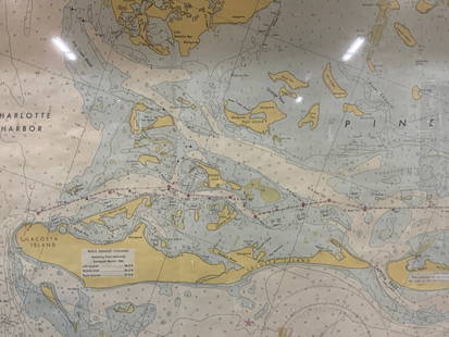
Sold2024Vintage Framed Pine Island & Lacoste Island MapVintage full color paper map, marked on top Pine island, Charlotte harbor and Lacosta island. Showing waterways and directions. Framed in a wooden frame. Approx 14 x 18 inches window measures 11.5 x 1See Sold Price
Sold2022[BERMUDA] Pair of vintage map posters. Including:[BERMUDA] Pair of vintage map posters. Including: PETRUCCELLI, A. Bermuda. 1966. 24 1/8 x 39 5/8”. Linen backed. Minor repaired tears in margins. – The Bermuda Islands. USA: Bermuda TradeSee Sold Price
Sold20241775-1780 North West Africa with Cape Verde and Canary Islands. By Bonne and RaynalTitle: 1775-1780 North West Africa with Cape Verde and Canary Islands. By Bonne and Raynal Date/Period: 1775-1780 Materials: Copperplate engraved Size: 15 ” x 9 “ This vintage map, createdSee Sold Price
Sold2023Vintage Mid Century Aerial Photograph Collage Map of Nantucket IslandVintage Mid Century Aerial Photograph Collage Map of Nantucket Island, circa 1951, compiled by the U.S. Department of Agriculture, Production and Marketing Administration, constructed by overlaying aeSee Sold Price
Sold2021Two Framed Vintage Maps of NantucketOne is a map of the island, the other a street map with vignettes of historical landmarks. Both published by Mitchell's Book Corner in 1973, both 17H inches x 22W inchesSee Sold Price
Sold2022Long Island Pictorial MapA Map of Long Island. Courtland Smith. Billboard Barn: 1933. Vintage map. Scattered creases. Overall 22 1/2" x 30".See Sold Price
Oct 12JM Hobby Supply and Railroad Artifact AuctionsChicago Rock Island and Pacific RY Employee Timetable #41-8/7/1932$10
Oct 12JM Hobby Supply and Railroad Artifact AuctionsChicago Rock Island and Pacific RY Employee Timetable #42-10/30/1932$10
2 days LeftJasper52Port di Napoli. Naples, Italy. ADMIRALTY sea chart 1937 (1955) old vintage map$300
2 days LeftJasper52Africae / Africa by Bertius / Langenes 1603 old antique vintage map plan chart$260
4 days LeftCarnegie's Auction GalleryRookwood Art Pottery 1932 Vintage Blue Colonial Women Ceramic Bookends 6252$250
2 days LeftRapid Estate Liquidators and Auction GalleryVintage Stamps Samoa 1926 SC 154-155a MLH Set$1(1 bid)
Oct 05Ripley Auctions“Visscher’s American Islands” Map (Insulae Americanae) by Nicolaes Visscher I (1619-1709)$800
2 days LeftJasper52Palestine Federal State Plan - Minority proposal. United Nations UNSCOP 1947 map$600


![[BERMUDA] Pair of vintage map posters. Including:: [BERMUDA] Pair of vintage map posters. Including: PETRUCCELLI, A. Bermuda. 1966. 24 1/8 x 39 5/8”. Linen backed. Minor repaired tears in margins. – The Bermuda Islands. USA: Bermuda Trade](https://p1.liveauctioneers.com/928/230548/119288256_1_x.jpg?height=310&quality=70&version=1639776029)


