Sold2020VINTAGE 1932 SUPERVUE MAP of NYC NEW YORK CITY, SAMUELVINTAGE 1932 SUPERVUE MAP of NYC NEW YORK CITY, SAMUEL FREEDMEN, SOUVENIR TRAVEL VINTAGE 1932 SUPERVUE MAP of NYC NEW YORK CITY, SAMUEL FREEDMEN, SOUVENIR TRAVEL Old Vintage NEW YORK CITY Tourist's MaSee Sold Price
Sold2022Vintage Map Print - America - Map of Manhattan - New York City - United StatesTitle: Vintage Map Print - America - Map of Manhattan - New York City - United States Date/Period: 1938 Dimension: 33 cm x 26 cm Material: Paper Additional Information: Vintage map of Manhattan. ThisSee Sold Price
Sold2021Fine map of New York City and Brooklyn, 1872Title: Fine map of New York City and Brooklyn, 1872 Description: Beautifully centered double-page vintage map of Manhattan Island and Brooklyn, with inset of the Northern Portion of New York City andSee Sold Price
Sold2023Vintage Maps of New York City - LithographsTwo vintage color lithograph maps of New York City, "Wards and Senate Districts", one framed in plexiglass, the other matted. Provenance: Phyllis Lucas Gallery, NYC. [Art: 7.5" H x 36" W; Frame: 14" HSee Sold Price
Sold2021Vintage Map Of Greenwich Village, New York CityOriginal 1960 map of Greenwich Village, New York City by Lawrence Fahey. Stated 1st edition. Dimensions: 25" X 38" overall including frameSee Sold Price
Sold2023Antique & Vintage Ephemera, NYC Maps & MoreA group lot of vintage and antique ephemera. Primarily New York / New York City ephemera. Maps, bookmarks, and more. One small book measuring 3.5H x 2.5W titled OLD NEW YORK, by HENRY COLLINS BROWN, CSee Sold Price
Sold2020Vintage How To Get There Map Of New York CityThis is an excellent map of New York City by the Barkan System Street Directory Company in 1946. The map covers the boroughs of Manhattan and the Bronx in extraordinary detail. In Manhattan, it coversSee Sold Price
Sold2021VINTAGE OLD NEW YORK CITY MAP, 4 in 1, MANHATTAN,VINTAGE OLD NEW YORK CITY MAP, 4 in 1, MANHATTAN, SUBWAY, FINANCIAL SECTION etc. VINTAGE OLD NEW YORK CITY MAP, 4 in 1, MANHATTAN, SUBWAY, FINANCIAL SECTION etc. Description Old Vintage GEOGRAPHIA LATSee Sold Price
Sold2021Scarce SDUK map of New York City, 1840Elusive vintage 1840 Society for the Diffusion of Useful Knowledge (S.D.U.K.) city map or plan of New York City. Shows southern Manhattan from the Battery northwards to 42nd Street and portions of adjSee Sold Price
Sold2023US WALL MAPS AND AERIAL VIEW OF NEW YORK CITYA lot of three antique and vintage wall maps of New York. The lot includes a 1914 map of New York bay and harbor, a D. Lambert Railing Co. color map of New York State, and an aerial view of Hudson RivSee Sold Price
Sold2018Map of New York City - National City BankNational City Bank of New York. 1932 with bank locations at reverse. 18-3/4" x 22-1/4"See Sold Price
Sold2022VINTAGE HAND DRAWN PLAN FOR PARCELLATION OF NYCA rare hand drawn and hand inscribed urban plan for parcellation of New York City. Historical American Architectural Documents, Urban Maps, Vintage Gifts And Collectibles. Dimensions: 17" x 12 1/4" inSee Sold Price
Sold2022Lot of 3 Various Maps of New York CityLot of 3 various maps of New York City, all show various stages of wear, yellowing, slight age staining & some ripping (mostly at the folds): Panorama of the New York Zoological Park, The Supervue MapSee Sold Price
Sold2020Vintage New York City Subway Wall MapVintage New York City Subway wall map. 41" x 26".See Sold Price
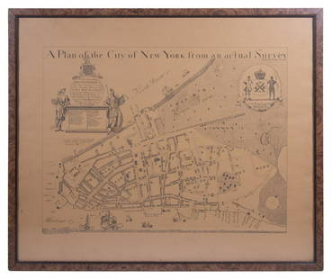
Sold2023REPLICA OF LAING'S MAP OF MANHATTAN"A Plan of the City of New York from an actual Survey" for His Excellency John Montgomerie, by William Bradford, printed on tan paper, in a faux tortoiseshell frame, under glass, 23" x 26", good condiSee Sold Price
Sold2019Vintage Bus Travel Ephemera and PhotosIncluding "Greyhound Lines, several "Blue Ridge Lines". several New York City bus maps and various glossy bus photos from the early 20th century.See Sold Price
Sold2022Map of Paris 1576Map of Paris French Munster copy of 16th Century Walled City Framed Great Graphics & Really Interesting Map print not engraving Great Vintage Condition Measuring 18" x 17" Out of New York City EstateSee Sold Price
Sold2021Goerck/Mangin Plan of N. Y. City, Scarce 1856 HaywardManhattan. The 1856 Hayward edition, illustrated in D. T. Valentine’s Manual, is said to be the only vintage version of this map attainable by most collectors. The Common Council of New York comSee Sold Price
Sold20211880 Gray Map of New York City -- New York City,Title: 1880 Gray Map of New York City -- New York City, Brooklyn, Jersey City, Hoboken Etc. Cartographer: O Gray Year / Place: 1880, Philadelphia Map Dimension (in.): 16.3 X 24.4 in. This is a fantastSee Sold Price
Sold20171865 Colton New York City Map1865 Colton New York City Map -- New York City Brooklyn, Jersey City, Hoboken, Etc. C. B. Colton 1865 New York 24 x 17 in. This nice map of New York City, including Manhattan, Brooklyn, Jersey City anSee Sold Price
Sold2017Map of New York City[ANTIQUARIAN MAP; NEW YORK CITY] MAP OF NEW YORK CITY Showing Portions of Brooklyn, Jersey City, and Westchester Co., Rand-McNally & Co., 1899, original large map 27” high x 22” across including aSee Sold Price
Sold2017New York City and Brooklyn MapEntered according to Act of Congress the Year 1880 by S. Augustus Mitchell in the Office of the Library of Congress at Washington. 14"h x 21"wSee Sold Price
May 19The Heritage Gallery at Sayville Antiques, IncWPA Style O/C NYC View Lower Manhattan From Staten Island$110(2 bids)
7 days LeftFreeman's | HindmanClaes Oldenburg (American, 1929-2022) - Proposed Colossal Monument for Staten Island, New York City$9,000
18 hrs LeftRapid Estate Liquidators and Auction GalleryBoy Scout Council Shoulder Badges Lot Of 24 C$85
Jun 09Estate Collection Auctioneer1986 Photo The Staten Island Anchorage viewed from Narrows Bridge Tower$250
May 16Potter & Potter Auctions[NEW YORK CITY – PICTORIAL MAPS]. Group of 3 pictorial maps...$200(1 bid)
4 days LeftWhite Knight Auction, IncHenri Cartier Bresson, 1947 New York City Manhattan Fire Aftermath$100


![Map of New York City: [ANTIQUARIAN MAP; NEW YORK CITY] MAP OF NEW YORK CITY Showing Portions of Brooklyn, Jersey City, and Westchester Co., Rand-McNally & Co., 1899, original large map 27” high x 22” across including a](https://p1.liveauctioneers.com/1163/104811/53672586_1_x.jpg?height=310&quality=70&version=1496428876)


![[NEW YORK CITY – PICTORIAL MAPS]. Group of 3 pictorial maps... (1 of 3)](https://p1.liveauctioneers.com/928/325952/175495562_1_x.jpg?height=282&quality=70&version=1712935174)


