Sold2021ROBERT DE VAUGONDY MAP OF SOUTH AMERICA, C. 1750Robert de Vaugondy (French, 1686-1766). "Amerique Meridionale" -1750, engraving with hand coloring. Approx. 20" x 24.75' (sheet)See Sold Price
Sold2021Large Map of North Carolina and South CarolinaLarge Map of North Carolina and South Carolina With map of Georgia and Florida[separately] on versos Cartographer: George Franklin Cram Dated: Circa 1900See Sold Price
Sold202119th c. NEW MAP OF SOUTH CAROLINARare 19th c. A New Map of South Carolina with its Canals, Roads & Distances from place to place along the Stage & Steam Boat Routes. By H.S. Tanner c. 1841-1845. Fine example of Tanner's map of SouthSee Sold Price
Sold2023Emanuel Bowen Map North & South Carolina, Georgia[Emanuel Bowen Map of North & South Carolina and Georgia] , "A New & Accurate Map of the Provinces of North & South Carolina Georgia & c. Drawn from late Surveys and regulated by Astron Observat. By ESee Sold Price
Sold2022Bowen - Map of North and South CarolinaEmanuel Bowen (1694-1767), A New & Accurate Map of the Provinces of North & South Carolina, Georgia, & C., London, circa 1747, in two sheets, engraving on laid paper, with title cartouche in the upperSee Sold Price
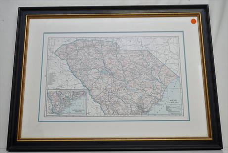
Sold2021HAMMONDS COMPLETE MAP OF SOUTH CAROLINAVintage Hammonds Complete Map of South Carolina. Showing all the railroad routes. c. 1930s. Professionally framed and matted. In frame measures 26 3/4"x20"x 1 1/4". Weight 7 pds. PROVENANCE: A PrivateSee Sold Price
2023Bowen, Thomas 1789 Large Map. South America"An Accurate Map of South America" Copper Engraved Map Published 1789-91 by C. Cooke, London for "The New Royal Encyclopedia, Or, Complete Modern Universal Dictionary of Arts and Sciences..." by WilliSee Sold Price
Sold2023Bowen, Thomas 1789 Large Map. South America"An Accurate Map of South America" Copper Engraved Map Published 1789-91 by C. Cooke, London for "The New Royal Encyclopedia, Or, Complete Modern Universal Dictionary of Arts and Sciences..." by WilliSee Sold Price
Sold20211779 NEW AND ACCURATE MAP OF SOUTH CAROLINAA New And Accurate Map Of The Province Of South Carolina In North America. London: Universal Magazine, c. 1779. Good, showing folds, 2 small tears to edges. Narrow margins. The map shows trails and paSee Sold Price
Sold20191807 Map Charleston, South CarolinaPublished Philadelphia by C.P. Wayne. The piece titled ÒPlan of the Siege of Charleston in S. CarolinaÓ. Sight size: H10" W15" (without frame)See Sold Price
Sold20201894 Cowles Civil War Map of South Carolina and PartsTitle/Content of Map: 1894 Cowles Civil War Map of South Carolina and Parts of North Carolina -- General Topographical Map, Sheet IV [Plate CXXXIX] Date: 1894, Washington Cartographer: C Cowles (compiSee Sold Price
Sold20202 antique framed Southern maps2 antique framed maps: Map of South Carolina in German dated 1845. Map of Savannah and Charleston published by G.W and C.B Colton & Co and dated 1855. Overall size measures 25 1/2"h x 28"w and the papSee Sold Price
Sold2017Rare 1967 Mouzon Map of North & South Carolinavery limited production by Louis and Clark Explorer Maps LLC in Kitty Hawk, and Charlotte, North Carolina. reproduction gives excellent detail and very well resembles the original map. marked "L&C" atSee Sold Price
Sold2019LANE PALMISANO (20th c, South Carolina) Landscape48 x 36 in. Large oil on canvas. Vibrant colors. Floating frame.See Sold Price
Sold2021Three South Carolina MapsPreliminary Chart of Port Royal Entrance, Beaufort Chechessee and Colleton Rivers... U.S. Coast Survey Office, Superintendent A. D. Bache, triangulation by C. O. Boutelle... 1859, single sheet, engravSee Sold Price
Sold2023Jaillot Map of South America with Exceptional ColorJAILLOT, Alexis Hubert (1632-1712). L'Amerique Meridionale. Engraved map with exceptional original color. Paris, c. 1691. 24 3/4" x 36 1/4" sheet. Large format map of South America, based upon earlierSee Sold Price
Sold2019North & South Carolina Early MapJohnson's North Carolina and South Carolina. Antique Map. A.J. Johnson, New York, c. 1866-70.. 18" x 26 1/2".See Sold Price
Sold2023HERMAN MOLL (ENGLISH, C. 1654-1732) MAP OF NORTH AND SOUTH CAROLINAHERMAN MOLL (ENGLISH, C. 1654-1732) MAP OF NORTH AND SOUTH CAROLINA, hand-colored engraving on laid paper, titled "CAROLINA / By / H. Moll Geographer" in a rectangular cartouche along lSee Sold Price
Sold20191864 Johnson Map of North and South Carolina --Title/Content of Map: 1864 Johnson Map of North and South Carolina -- Johnson's North and South Carolina Date: 1864, New York Cartographer: Johnson & WardSize: 17.3 x 24 in. An excellent, large, doublSee Sold Price
Sold2020SOUTHERN STATES TRADE ROUTE MAPLarge Framed Trade Route Map showing waterways and towns from the Mississippi River to Charles Town. Geographic Area Covered: Southern States, South Carolina,Santee River Valley, Savannah River ValleySee Sold Price
Sold2022A MAP OF VIRGINIA, NORTH AND SOUTH CAROLINA, GEORGIA, MARYLAND, WITH PART OF NEW JERSEY, & C, 1755.A MAP OF VIRGINIA, NORTH AND SOUTH CAROLINA, GEORGIA, MARYLAND, WITH PART OF NEW JERSEY, & C, 1755. - 9 x 11 in; frame: 12.5 x 14.5 in.See Sold Price
Sold2021CHARLESTON MAP BIRDS EYE VIEW 1872Fine birdseye view of South Carolina, published in Baltimore by C. Drie C. 1872. This map is the artists impression of how the city of Charleston was in 1872. This birds eye view of the city is lookinSee Sold Price
Sold2019Large Collection of 19th Century MapsVarious makers, engravers and publishers. See photos for details. Fair to good condition as shown. George CRAM, Johnsons Georgia and Alabama, Johnsons and Ward NEW YORK, J.H. Colton South Carolina andSee Sold Price
Sold2018Charles Councell(South Carolina/District of Columbia/Indiana, 1896-1985) Watercolor of the Clemson, South Carolina plantation home of John C. Calhoun called Fort Hill Mansion. The piece is large and signed lower righSee Sold Price
May 18Blackstone Valley Auctions & Estates LLCRevolutionary Era War Map of the Attack on Ft. Moultrie.$120(2 bids)
May 18Rich Penn AuctionsDecorative Art, map of South America, late 18th C., framed & matted, Exc cond, 24"H x 20"W overall.$50
May 21Freeman's | HindmanVerot & Clément c. 1955 Satinwood Cabinet with Painted Roundels France$3,250(5 bids)
May 21Freeman's | HindmanPhilip and Kelvin Laverne (American, 1907-1987 | b. 1937) Laverne Spring Festival Coffee Table, c.$2,500(1 bid)
May 21Freeman's | HindmanPhilip and Kelvin LaVerne (American, 1907-1987 | b. 1937) Pair of Tao Occasional Tables, c. 1965$3,000(1 bid)
May 21Freeman's | HindmanPiero Fornasetti (Italian, 1913-1988) Uccelli Folding Screen, designed c. 1953 Italy$5,000
May 21Freeman's | HindmanW. B. Mundie for Teco Pottery (American, 1863–1939) Vase, model 287, c. 1904 Teco, USA$800(2 bids)
May 21Freeman's | HindmanW.B. Mundie for Teco Pottery (American, 1863–1939) Vase, model 284, c. 1910 Teco, USA$750(1 bid)
May 21Freeman's | HindmanF. Moreau for Teco Pottery (French/American, 1853-1920) Vase, model 127, c. 1910 Teco, USA$1,000(1 bid)


![Large Map of North Carolina and South Carolina: Large Map of North Carolina and South Carolina With map of Georgia and Florida[separately] on versos Cartographer: George Franklin Cram Dated: Circa 1900](https://p1.liveauctioneers.com/5614/198722/101907570_1_x.jpg?height=310&quality=70&version=1618847492)

![Emanuel Bowen Map North & South Carolina, Georgia: [Emanuel Bowen Map of North & South Carolina and Georgia] , "A New & Accurate Map of the Provinces of North & South Carolina Georgia & c. Drawn from late Surveys and regulated by Astron Observat. By E](https://p1.liveauctioneers.com/268/293228/155705053_1_x.jpg?height=310&quality=70&version=1687296979)


![1894 Cowles Civil War Map of South Carolina and Parts: Title/Content of Map: 1894 Cowles Civil War Map of South Carolina and Parts of North Carolina -- General Topographical Map, Sheet IV [Plate CXXXIX] Date: 1894, Washington Cartographer: C Cowles (compi](https://p1.liveauctioneers.com/5584/162222/81927562_1_x.jpg?height=310&quality=70&version=1582719732)


