Sold2020Map of Asia coloured by hand Lithography 1864Map of Asia coloured by hand Author: different author Atlas: Atlante Geografico Universale Antico e Moderno Date: 1864 Technique: Lithography Leaf Dimension: 39x29 cm (15.35x11.42 inches) Engraving DiSee Sold Price
Sold2018Chiquet: Antique Map of Asia, 1719Map: Map of Asia Coloured by Hand 1719 Chiquet Etching On Copper Very beautiful map of Asia coloured by hand Author: Chiquet Jacques (1673-1721) Atlas: Le Nouveau et Curieux Atlas Geographique Date: 1See Sold Price
Sold2019Map America 1746 HomannAMERICAE Mappa Generalis Very beautiful map of America, big size, coloured by hand. Author: Homann Johan Baptist (1674-1724) publiched by Eredi. Atlante: Maior Atlas scholasticus ex triginta sex generSee Sold Price
Sold2018Lapie: Antique Map of North America, 1830Very beautiful map of North America, big size, coloured by hand. Author: Lapie M. (Pierre) (1779-1850) Atlas: Atlas universel de geographie ancienne et moderne Date: 1830 Technique: etching on steel LSee Sold Price
Sold2018Wyld, James C1840 Group of 4 Hand Coloured MapsIncl Spain/Portugal, Syria, Asia and Turkey in Asia. Hand Coloured Steel Engraved Map Published C1840, London for "Atlas of Modern Geography" by James Wyld. Centre fold as published. Paper Size: 11 xSee Sold Price
Sold2019Barclay, James 1809 Antique Map. AsiaOutline Hand Coloured Copper Engraved Map Published 1809, Leeds for "Barclay's Complete and Universal Dictionary of the English Language..." by the Rev. James Barclay. Paper Size: 10 x 8 inch (26 x 20See Sold Price
Sold2020Elliot, Daniel Giraud A Monograph of the Tetraoninae,New York: for the Author, 1864-1865. Large folio, 5 original parts in 4 volumes, 27 hand-coloured lithographs, original green printed boards, green clamshell box with black morocco gilt label to spineSee Sold Price
Sold2023Russell & Barclay 1839 Hand Col Map. AsiaHand Colored Copper Engraved Map Published 1823-40, by Fisher & Son, "A Complete Atlas of the World" by John Russell et al. A Very Rare Work which is compiled from the same plates used in different edSee Sold Price
Sold2019Mexican Gulf Cuba Haiti Jamaica Puerto Rico 1875CARTE DES ILES ANTILLES DES ETATS DE L’AMERIQUE CENTRALE ET DU GOLFE DU MEXIQUE Very beautiful map of Antilles, central America and Mexican Gulf, coloured by hand, big size. Author: Brue, AdrieSee Sold Price
Sold2018Mallet, Alain 1683 HC Map of Turkey in Asia, Black Sea"Turquie en Asie" Hand Coloured Copper Engraved Map Published 1683, Paris for "Description de l'Univers" by Alain Manesson Mallet. French text to verso. Paper Size: 8 x 5 inch (20 x 13cm) Good ConditiSee Sold Price
Sold2019Barclay, James 1809 Antique Map. Turkey & Black Sea"Turkey in Europe with Asia Minor" Outline Hand Coloured Copper Engraved Map Published 1809, Leeds for "Barclay's Complete and Universal Dictionary of the English Language..." by the Rev. James BarclaSee Sold Price
Sold2015Map of The Asia divided in different states. 1828Print of steel engraving titled L‘ Asie divisee en ses differens Etats“.Author Fellx Delamarche.Engraved by unknown.From Atlas de la Geographie ancienne du moyen age et moderne“ by Fellx DelamarSee Sold Price
Sold2016Victor Lavasseur. Map of Asia. 1830.Print of hand colored steel engraving titled „Asie“.Author Victor Lavasseur.Engraved by unknown.From „Atlas classique universel de Geographie anciene et moderne“ by Victor Levasseur. Paris. 18See Sold Price
Sold2015Victor Lavasseur. Map of Asia. 1830.Print of hand colored steel engraving titled Asie“.Author Victor Lavasseur.Engraved by unknown.From Atlas classique universel de Geographie anciene et moderne“ by Victor Levasseur. Paris. 1830.VicSee Sold Price
Sold20211873 Map of AsiaAuthor: Bartholomew Title: 1873 Map of Asia Medium: Ink on Paper Dimensions: 17.5"X13" Map of Asia dated 1873. Part of Zell's Descriptive Hand Atlas of the World. Published in Philadelphia by T. EllwoSee Sold Price
Sold2024Johnson's Asia. Bod or Tibet. Toorkistan Cabool Birmah Persia Corea 1865 mapCAPTION PRINTED BELOW PICTURE: 'Johnson's Asia' DATE PRINTED: 1865 IMAGE SIZE: Approx 34.0 x 41.5cm, 13.25 x 16.25 inches (Large) TYPE: Large, decorative hand coloured 19th century atlas map CONDITIONSee Sold Price
Sold2024Johnson's Asia. Bod or Tibet. Toorkistan Cabool Birmah Persia Corea 1861 mapCAPTION PRINTED BELOW PICTURE: 'Johnson's Asia' DATE PRINTED: 1861 IMAGE SIZE: Approx 33.5 x 41.5cm, 13.25 x 16.25 inches (Large) TYPE: Large, decorative hand coloured 19th century atlas map CONDITIONSee Sold Price
Sold2023Sanson map of ancient Asia 1650Heading: Author: Sanson, Nicolas Title: Asia Vetus Place Published: Paris Publisher: Date Published: [1650] Description: Copper-engraved map, hand-colored in outline; colored decorSee Sold Price
Sold2023Atlas: “Mitchell’s New General Atlas,” Augustus Mitchell, 1864Hand-colored lithographic maps, original boards disbound, lacks maps of Louisiana, California, Utah, Asia, Denmark, Switzerland and Hindoostan, remaining maps with bright colors Sold as a collection oSee Sold Price
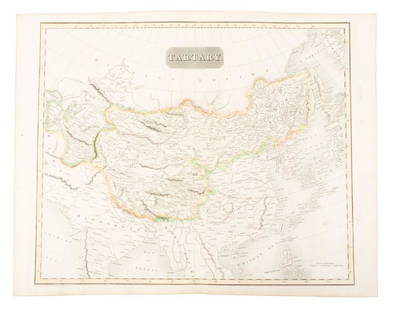
Sold2019Map of Tartary comprising most of AsiaHeading: (Maps) Author: Thomson, John Title: Tartary Place Published: Edinburgh Publisher: Date Published: 1814 Description: Engraved map, hand-colored in outline. 49.8x59.5See Sold Price
Sold2017Johnson: Antique Map of Asia, 1864Map: 1864 Johnson Map of Asia -- Johnson's Asia Date Printed: 1864, New York Cartographer: Johnson & Ward Size: 12.5 x 15.5 in. Condition: Good overall. A 1.5 in. split (likely caused by a finger) thaSee Sold Price
Sold202218th & 19th C. MAPS OF ASIA (3 MAPS)Includes: 2 maps by John Tallis & Co. London / New York, ca. 1850, both matted and framed, including: (1) MAP OF ASIA. Hand colored engraved map. 5 hand colored vignettes. H. 10.25", W. 12.75"; (2) MASee Sold Price
Sold20201738 MAP OF EGYPT W/ LYBIA (HAND COLOURED MAP BY1738 MAP OF EGYPT W/ LYBIA (HAND COLOURED MAP BY D/ANVILLE)See Sold Price
Sold2018Framed antique hand coloured map of the Isle of WightFramed antique hand coloured map of the Isle of WightSee Sold Price
2 days LeftJasper52COLONIES FRANÇAISES MARTINIQUE AMÉRIQUE DU SUD. West Indies.LEVASSEUR 1856 map$45
2 days LeftJasper52COLONIES FRANÇAISES EN AMÉRIQUE. Caribbean Guadeloupe. LEVASSEUR 1856 old map$45
2 days LeftJasper52COLONIES FRANÇAISES AMÉRIQUE. Guyane Newfoundland Miquelon. LEVASSEUR 1856 map$70
3 days LeftForum AuctionsGeology.- Bristow (Henry William) The Geology of the Isle of Wight, hand-coloured maps, 1862 &£50
3 days LeftForum AuctionsBeaumont (Cyril W.) Impressions of the Russian Ballet: La Boutique Fantastique, one of 40 copies on£100
2 days LeftJasper52Amér. Mér. Guyane Anglaise #4 bis. Guyana Suriname. VANDERMAELEN 1827 old map$35
Featured2 days LeftJasper52Amér Sep Grandes Antilles 73 Jamaica Pedro Bank San Andrés VANDERMAELEN 1827 map$45
2 days LeftJasper52Amér Sep Porto Rico #69 Puerto Rico & Virgin Islands VANDERMAELEN 1827 old map$140
2 days LeftJasper52Amér. Sep. Curacao #74. Aruba Bonaire Puerto Rico Beata. VANDERMAELEN 1827 map$140
2 days LeftJasper52Amér. Sep. Ile de Cuba #67. Cuba & Jamaica Cayman Islands. VANDERMAELEN 1827 map$160
3 days LeftForum AuctionsCartography.- Cary (John) A New Map of England...1821, hand-coloured engraved map, 1823 & others£50
3 days LeftForum AuctionsDeseine (François) Rome Moderne, vol.2-6 only (of 6), engraved plates, contemporary calf over£75
Featured2 days LeftJasper52GUADELOUPE. Marie-Galante, Désirade, Iles des Saintes.Vuillemin. 1903 old map$15
5 days LeftTrillium Antique Prints & Rare BooksDe Jode, Rare, pub. 1593 - Map of Asia (Tertiae Partis Asiae)$100(1 bid)
Dawsons AuctioneersBeighton Henry: 'A Map of Knightlow-Hundred', 1725, hand coloured, 34.5 cm x 36 cm, together with Ki£40
3 days LeftForum AuctionsAlmanacks.- Kalendario Manual, y Guia de Forasteros en Madrid, 2 parts in 1, Madrid, 1791 & others,£150
Featured2 days LeftJasper52Johnson's West Indies. Bermuda Islands. Caribbean Bahamas Antilles 1866 map$120
3 days LeftForum AuctionsBirds.- Hale (W.G.) The Meyers' Illustrations of British Birds, one of 40 de luxe copies with an£150


![Sanson map of ancient Asia 1650: Heading: Author: Sanson, Nicolas Title: Asia Vetus Place Published: Paris Publisher: Date Published: [1650] Description: Copper-engraved map, hand-colored in outline; colored decor](https://p1.liveauctioneers.com/642/310901/166355383_1_x.jpg?height=310&quality=70&version=1701367957)