Sold2023Rare 1st edition/1st state of County Map of Maine, Mitchell 1860From the exceptionally rare first printing of the 1860 New General Atlas by Samuel Augustus Mitchell Jr. This was Mitchell Jr’s first project after taking over his father’s business and heSee Sold Price
Sold2018Mitchell: Antique Map of Maine, 1860Title/Content of Map: 1860 Mitchell Map of Maine -- County Map of the State of Maine Date Printed: 1860, Philadelphia Cartographer: S Mitchell Size: 13.2 X 10.5 in. A very nice pastel color coded counSee Sold Price
Sold2021Vintage county and RR map of Maine by Mitchell, 1860Title: Vintage county and RR map of Maine by Mitchell, 1860 Description: Beautiful map of the unique state of Maine with hand coloring by county. Maine, our eastern-most state, is surrounded by anotheSee Sold Price
Sold2022Nice 1860 map of Maine with full hand coloringVery nice vintage map of Maine with original hand coloring by county. Features signature floral border that makes Mitchell maps stand apart. Railroads clearly delineated and named. Shows coastal featuSee Sold Price
Sold20165 vols: Drayman's account book, Peter Filbert...[Manuscripts/Account Books] 5 Vols. ++ Drayman’s record book. 1827-1843. Maintained by a drayman in Hancock County, Maine. It records rentals of horses for trips to Penobscot, Castine, Blue Hill, anSee Sold Price
Sold20171860 County Map of California1860 County Map of California Inset showing settlements in Great Salt Lake County. S. Augustus Mitchell, Jr. Engraved map with original hand-coloring by counties. Beautiful map of California with inseSee Sold Price
Sold2024SCHOOLROOM MAP OF OXFORD COUNTY MAINE 1853Linen Backed Handcolored Litho with battend and roller, "Map of Oxford County, Maine, from Surveys Under the Direction of H.F. Walling, 1858, Published by Gillette & Huntington, 90 Fulton St, New YorkSee Sold Price
Sold2023An 1860 Map, Counties of New York, New Hampshire, Etc...Hand colored lithograph, by Samuel Augustus Mitchell (1790-1868). :County Map of the States of New York, New Hampshire, Vermont, Massachusetts, Rhode Island and Connecticut". Dimensions:15 1/2" x 23 1See Sold Price
Sold2021J. Chase 1856 Map of Kennebec County Maine.57 x 58 inches, losses to top of map, top bar partially detached. Philadelphia and Boston: J.L. Smith, 1856See Sold Price
Sold20181867 Mitchell Map of Maine -- County Map of the StateTitle/Content of Map: 1867 Mitchell Map of Maine -- County Map of the State of Maine Date: 1867, Philadelphia Cartographer: S Mitchell Size: 13.3 x 10.7 in. This is a very nice map of Maine. Great deaSee Sold Price
Sold20222 Topographical Maps of Warren County, New Jersey2 topographical maps of Warren County, New Jersey. Largest map: Sight: 23" x 15 1/4". Frame: 26 3/4" x 18 1/4" . Toning to both maps.See Sold Price
Sold20191876 Mitchell Map of Maine -- County Map of the StateTitle/Content of Map: 1876 Mitchell Map of Maine -- County Map of the State of Maine Date: 1876 Philadelphia Cartographer: S MitchellSize: 13.4 X 10.6 in. This is a very nice map of Maine with inset oSee Sold Price
Sold2019Eight (8) Augustus Mitchell MapsCollection of eight maps including New Jersey/Maryland Delaware 1872, Two north and South Carolina 1872 maps (15" x 12"), Minnesota 1890 , Florida and the Carolinas 1860, County map of the state of ArSee Sold Price
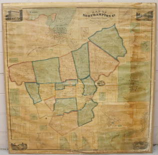
Sold2022MAP OF NORTHAMPTON COUNTY, PA 1860LINEN BACKED MAP MOUNTED ON BACKBOARD UNDER PLEXIGLASS (NO FRAMEWORK). SMITH,GALLUP & CO. PUBLISHERS, PHILADELPHIA, 1860. MEASURES 60" X 58". Terms & Conditions: Pick-up for this Auction will be WedneSee Sold Price
Sold2021Shearer's Map of York County, PA 1860Measures approx. 5' by 5'. It has lithography of important buildings along border; has some water damage and is fractured at top.See Sold Price
Sold2021Shearer's Map of York County, PA 1860Measures approx. 5' by 5'. It is a map of York County, PA with lithographs of important buildings on border. It has tape on Spring Garden section, as well as tape covering entire top section, approx.See Sold Price
Sold2022Railroad and County Map of Maine.Publication Date: 1889 Title: Railroad and County Map of Maine. Cartographer: CRAM, GEORGE F. Publisher: GEO. F. CRAM Height: 22 Width: 15.8 Detailed state map with railroads in colors. Ornamental titSee Sold Price
Sold2018Mitchell: Antique County Map of Maine, 1870County Map of the State of Maine The beautifully detailed and colored county map of Maine from the 1870 edition of Mitchell's popular New General Atlas of the world. Framed by the vine motif border tySee Sold Price
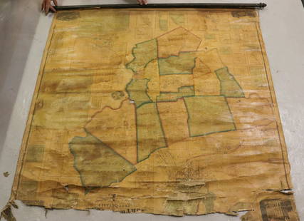
Sold2022MAP OF NORTHAMPTON COUNTY, PA 1860LINEN BACKED MAP. SMITH, GALLUP & CO. PUBLISHERS, PHILADELPHIA, 1860. MEASURES 56" X 57" Terms & Conditions: Pick-up for this Auction will be Wednesday August 3rd and Thursday August 4th from 9:00am tSee Sold Price
Sold20211860 York County MapFrom actual surveys by D.J. Lake. Published by W.O. Shearer & D.J. Lake. Includes business directory. Overall size 60" wide X 60" high. Canvas with losses and is brittle.See Sold Price
Sold20221898 Topographical Colored Maps of Worcester County,LJ Richards & Co. Pub. Plate #2 Worcester is missing Cover is detached 22" x 17" Please see photos and come to the 2 day preview for condition.See Sold Price
Sold20241859 Clark & Hopkins Wall Map Litchfield County CTAntique 1859 Clark & Hopkins Topographical Wall Map of Litchfield County Connecticut, Coated Fabric Backed Paper with Original Rollers. Measures 55 inches x 51 inches. Please note condition issues notSee Sold Price
Sold2022PHOTOLITHO REPRINT OF A 1828 MAP OF TOWNSHIPS IN LINCOLN COUNTY, MAINE"Projected by Martha P. Haskell, Winthrop, AD 1828", color photolitho, in dark oak panel frame, under glass, OS: 18" x 22 1/2", SS: 15 1/2" x 19". Good condition (stains are part of the print).See Sold Price
Sold2023State of Maine historical chairOak arm chair with ancient handwritten note glued to bottom "Presented by Capt. Amzi Dingley of Hancock County in the State of Maine to his nephew James Ayer in 1898. This chair was used for the signiSee Sold Price
5 days LeftJasper52U.S. War Department. Map of the Yellowstone and Missouri Rivers and Their Tributaries.$240
5 days LeftJasper52New Map of That Portion of North America Exhibiting the United States and Territories...Mexico...$360
6 days LeftJasper52Oceania or Islands in the Pacific Ocean. Polynesia Australasia SWANSTON 1860 map$55
Featured6 days LeftJasper52New Zealand Sandwich Galapagos Islands. Papuan Archipelago. Melanesia 1860 map$130
May 16Potter & Potter AuctionsMcCARTY, Lea (1905 – 1960). Sonoma County / Its Highlights ...$100(1 bid)


![5 vols: Drayman's account book, Peter Filbert...: [Manuscripts/Account Books] 5 Vols. ++ Drayman’s record book. 1827-1843. Maintained by a drayman in Hancock County, Maine. It records rentals of horses for trips to Penobscot, Castine, Blue Hill, an](https://p1.liveauctioneers.com/179/96603/49249060_1_x.jpg?height=310&quality=70&version=1479429231)