Sold2022Antique Map - Map of Europe - Austrian Empire - Vienna - Salzburg - John DowerOriginal antique map of Austrian Empire by John Dower, published by Orr & Co. Technique: Steel Engraving. Date: 1840. Place: London, England. Size: 9” x 12” inches / 24 cm x 30 cm.See Sold Price
Sold2020AN ANTIQUE MAP, "Europe (Evrop)," JOHN SPEED,AN ANTIQUE MAP, "Europe (Evrop)," JOHN SPEED, CARTOGRAPHER, 1626-1676, hand-colored engraving on paper, Abraham Goos (1589-1643), engraver, published for merchants Thomas Basset and Richard Chiswell iSee Sold Price
Sold2019Cornwell & Dower 1849 Lot of 6 European MapsIncl Germany, Austria, Europe, Spain/Portugal, Prussia, and France. Steel Engraved Maps Published 1849, London for "A School Atlas" by James Cornwell. Maps by John Dower. Paper Size: 6.5 x 4 inch (16See Sold Price
Sold2020Colored Engraving, Map of Europe, Eman BowerA New and Accurate Map of Europe, Eman Bower circa 1760, colored engraving. Custom burlwood frames by Giovanni Baccani, Florence, 15" x 18" unframed, 23" x 26" framed. Provenance: John's Island, VeroSee Sold Price
Sold2022Pinkerton french Map of Europe Russia 1806John Pinkerton (Scottish, 1758-1826): Map of Europe and Russia 1806, copper hand colored engraving, from Abrege de la geographie moderne published in 1806 in Paris by Dentu Imprimeur.8 3/4" X 11&rdquoSee Sold Price
Sold2022Antique Map of Europe - Map of Switzerland - Geneva - Luzern - John LodgeA fine 1778 map of Switzerland by the English map publisher John Lodge. Technique: Hand colored steel engraving. Date: ca 1778. Artist: John Lodge. Place: London, England. Size: 10” x 8” iSee Sold Price
Sold2023Cary Antique Maps, Western European (4)Set of 4 maps including Europe, France, Netherlands, Portugal. John Cary, London, early 19th C. Hand-colored engravings. Center vertical folds, as issued.See Sold Price
Sold2016MAP OF EUROPE'EUROP, and the cheife Cities contaned therin', by John Speed, hand-colored engraving, London: Humber, 1626, framed, 18 x 22-3/4 in. (overall)See Sold Price
Sold2021Turkey in Asia & Europe.- Senex (John) Turky in EuropeTurkey in Asia & Europe.- Senex (John) Turky in Europe Corrected from Observations Communicated to the Royal Societys at London and Paris, large two-sheet map, engraving with some outline hand-colouriSee Sold Price
Sold2021Tallis, John (Pub) 1852 Map. EuropeSteel Engraved Map with Original Outline Hand Color Published 1852-56 by John Tallis, London for "The Universal Pronouncing Dictionary" by Thomas Wright. Drawn & Engraved by John Rapkin. Centre fold aSee Sold Price
Sold2021Wilkes, John 1804 Map. Ancient EuropeCopper Engraved Map Published 1796-1828 London for "Encyclopaedia Londinensis, or universal dictionary of arts, sciences and literature" by John Wilkes et al. Paper Size: 10.5 x 8.5 inch (27 x 22cm) VSee Sold Price
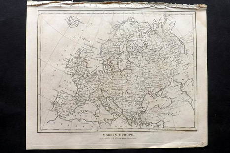
Sold2021Wilkes, John 1804 Map. Modern EuropeCopper Engraved Map Published 1796-1828 London for "Encyclopaedia Londinensis, or universal dictionary of arts, sciences and literature" by John Wilkes et al. Paper Size: 10.5 x 8.5 inch (27 x 22cm) VSee Sold Price
Sold2023Thomson, John (Pub) 1825 Map. EuropeCopper Engraved Map Published 1825 by John Thomson, Edinburgh for "The Edinburgh School Atlas" by N. R. Hewitt. Maps Engraved by Hewitt. Original Outline Hand Colour. Rare. Paper Size: 10.5 x 8 inch (See Sold Price
Sold2021Thomson, John (Pub) 1825 Map. EuropeCopper Engraved Map Published 1825 by John Thomson, Edinburgh for "The Edinburgh School Atlas" by N. R. Hewitt. Maps Engraved by Hewitt. Engraved Vignette in corner. Original Outline Hand Colour. RareSee Sold Price
Sold2024Walker, John C1805 Antique Map. EuropeCopper Engraved Map Published C1805, London for "The Universal Gazetteer: Being a Concise Description" [Walker's Geography] by John Walker. Folds as issued. Paper Size: 10 x 8 inch (25 x 20cm) Some wrSee Sold Price
Sold2019Walker, John 1795 Map of EuropeCopper Engraved Map Published 1795, London for "Elements of Geography, and of Natural and Civil History" by John Walker. Centre fold as published. Paper Size: 10 x 8.5 inch (26 x 22cm) Very minor toniSee Sold Price
Sold2023South America by John Dower. Gran Colombia. La Plata. Brazil 1845 old mapTitle: South America by John Dower. Gran Colombia. La Plata. Brazil 1845 old map Description: South America' by John Dower (1845). Antique map with original hand colouring, 28.0 x 22.5cm, 11 x 8.75 inSee Sold Price
Sold20211890 Sword & Pen Owens Willard Glazier War Mississippi1890 Sword & Pen Owens Willard Glazier War Mississippi Americana Engraving MAPS John Owens’ book ‘Sword and Pen’ is a biography of his childhood, life as a student and teacher, career as a soldiSee Sold Price
Sold2020Walker, John 1815 Antique Map of EuropeCopper Plate Published 1815, London for "The Universal Gazetteer: Being a Concise Description" [Walker's Geography] by John Walker. Folds as issued. Paper Size: 10 x 8 inch (25 x 20cm) Minor toning/ofSee Sold Price
Sold201918TH CENTURY LONDON TO HOLY HEAD ROAD ENGRAVINGEnglish road map engraving by John Ogilby "London to Holy Head" from 1735. Measures 27.5" x 23" w/ frame.See Sold Price
Sold201918TH CENTURY LONDON TO CARLISLE ROAD ENGRAVINGEnglish road map engraving by John Ogilby "London to Carlisle" from 1735. Measures 27.5" x 23" w/ frame.See Sold Price
Sold2021ANTIQUE ENGRAVING ON PAPER, H 15", W 20", NEW MAP OFANTIQUE ENGRAVING ON PAPER, H 15", W 20", NEW MAP OF EUROPE An antique engraving on paper titled "A New Map Of Europe," dedicated to William Duke of Gloucester. Frame measures H 23" x L 28".See Sold Price
Sold2017Map of Sicily Islands 1814Engraving, Map by John Pinkerton, 1814. Map features just islands but was part of a four panel map grid. Dimensions: 11 1/4" x 14 1/4" Please note that this lot has a confidential reserve. When you leSee Sold Price
Sold2019Cornwell & Dower 1849 World Hemisphere MapSteel Engraved Map Published 1849, London for "A School Atlas" by James Cornwell. Maps by John Dower. Paper Size: 6.5 x 4 inch (16 x 10cm) Very minor toning. Good conditionSee Sold Price
7 hrs LeftTrillium Antique Prints & Rare BooksPtolemy & Magini, pub. 1620 - Map of the Ancient World with Africa, Europe, Asia$50
5 days LeftHunt and Peck Estate Services, Inc.1775 John Hinton Vol. 56 "The Universal Magazine of Knowledge and Pleasure"$50
7 hrs LeftTrillium Antique Prints & Rare BooksWebber & Cook, Rare - View in the Island of Cracatoa$500
7 hrs LeftTrillium Antique Prints & Rare BooksWebber & Cook, Rare - A View in Oheitepeha Bay, in the Island of Otaheite$500
7 hrs LeftTrillium Antique Prints & Rare BooksLear & Gould - Eastern Great Horned Owl (Bubo Ascalaphus)$100
7 hrs LeftTrillium Antique Prints & Rare BooksWebber & Cook, Rare - A View in the Islands of Pulo Condore$500
May 11Trillium Antique Prints & Rare BooksWebber & Cook, Rare - View of the Harbour of Taloo, in the Islands of Eimeo$500
May 11Trillium Antique Prints & Rare BooksWebber & Cook, Rare - A Toopapaoo of a Chief, with a Priest Making His Offering to the Morai, in$500


![Walker, John C1805 Antique Map. Europe: Copper Engraved Map Published C1805, London for "The Universal Gazetteer: Being a Concise Description" [Walker's Geography] by John Walker. Folds as issued. Paper Size: 10 x 8 inch (25 x 20cm) Some wr](https://p1.liveauctioneers.com/3952/320085/171971891_1_x.jpg?height=310&quality=70&version=1708266709)


![Walker, John 1815 Antique Map of Europe: Copper Plate Published 1815, London for "The Universal Gazetteer: Being a Concise Description" [Walker's Geography] by John Walker. Folds as issued. Paper Size: 10 x 8 inch (25 x 20cm) Minor toning/of](https://p1.liveauctioneers.com/3952/178586/89905084_1_x.jpg?height=310&quality=70&version=1599488807)


![[POTTERY]. Pair of Rare Illustrated Jugs Plus a Rare Illust... (1 of 1)](https://p1.liveauctioneers.com/928/328184/176813309_1_x.jpg?height=282&quality=70&version=1714496988)


