Sold2021Wilkes, John 1804 Map. Ancient EuropeCopper Engraved Map Published 1796-1828 London for "Encyclopaedia Londinensis, or universal dictionary of arts, sciences and literature" by John Wilkes et al. Paper Size: 10.5 x 8.5 inch (27 x 22cm) VSee Sold Price
Sold2022Wilkes, John 1804 Pair of Maps. Ancient & Modern EuropeCopper Engraved Map Published 1796-1828 London for "Encyclopaedia Londinensis, or universal dictionary of arts, sciences and literature" by John Wilkes et al. Paper Size: 10.5 x 8.5 inch (27 x 22cm) VSee Sold Price
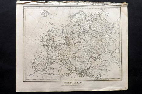
Sold2021Wilkes, John 1804 Map. Modern EuropeCopper Engraved Map Published 1796-1828 London for "Encyclopaedia Londinensis, or universal dictionary of arts, sciences and literature" by John Wilkes et al. Paper Size: 10.5 x 8.5 inch (27 x 22cm) VSee Sold Price
Sold2021Wilkes, John 1804 Map. England & WalesCopper Engraved Map Published 1796-1828 London for "Encyclopaedia Londinensis, or universal dictionary of arts, sciences and literature" by John Wilkes et al. Paper Size: 10.5 x 8.5 inch (27 x 22cm) GSee Sold Price
Sold2021Wilkes, John 1804 Map. BedfordshireCopper Engraved Map Published 1796-1828 London for "Encyclopaedia Londinensis, or universal dictionary of arts, sciences and literature" by John Wilkes et al. Paper Size: 10.5 x 8.5 inch (27 x 22cm) TSee Sold Price
Sold2021Wilkes, John 1804 Map. OxfordshireCopper Engraved Map Published 1796-1828 London for "Encyclopaedia Londinensis, or universal dictionary of arts, sciences and literature" by John Wilkes et al. Paper Size: 10.5 x 8.5 inch (27 x 22cm) VSee Sold Price
Sold2021Wilkes, John 1804 Map. France in 1805Copper Engraved Map Published 1796-1828 London for "Encyclopaedia Londinensis, or universal dictionary of arts, sciences and literature" by John Wilkes et al. Paper Size: 10.5 x 8.5 inch (27 x 22cm) VSee Sold Price
Sold2021Wilkes, John 1798 Map. Ancient AfricaCopper Engraved Map Published 1796-1828 London for "Encyclopaedia Londinensis, or universal dictionary of arts, sciences and literature" by John Wilkes et al. Paper Size: 10.5 x 8.5 inch (27 x 22cm) GSee Sold Price
Sold2022Wilkes, John 1804 Antique Map of Essex, UKCopper Engraved Map Published 1796-1828 London for "Encyclopaedia Londinensis, or universal dictionary of arts, sciences and literature" by John Wilkes et al. Paper Size: 10.5 x 8.5 inch (27 x 22cm) GSee Sold Price
Sold2021Wilkes, John C1815 Map. Ancient AsiaCopper Engraved Map Published 1796-1828 London for "Encyclopaedia Londinensis, or universal dictionary of arts, sciences and literature" by John Wilkes et al. Paper Size: 10.5 x 8.5 inch (27 x 22cm) TSee Sold Price
Sold2021Wilkes, John 1807 Hand Col Map. Ancient Britain"Britannia Antiqua" Finely Hand Colored Copper Engraved Map Published 1796-1828 London for "Encyclopaedia Londinensis, or universal dictionary of arts, sciences and literature" by John Wilkes et al. PSee Sold Price
Sold2021Wilkes, John 1807 Hand Col Map. Ancient Spain"Hispania Antiqua" Finely Hand Colored Copper Engraved Map Published 1796-1828 London for "Encyclopaedia Londinensis, or universal dictionary of arts, sciences and literature" by John Wilkes et al. PaSee Sold Price
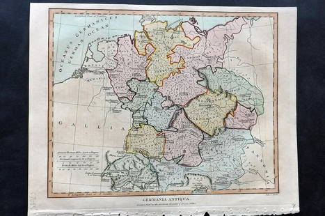
Sold2021Wilkes, John 1807 Hand Col Map. Ancient Germany"Germania Antiqua" Finely Hand Colored Copper Engraved Map Published 1796-1828 London for "Encyclopaedia Londinensis, or universal dictionary of arts, sciences and literature" by John Wilkes et al. PaSee Sold Price
Sold20201747 Map of Ancient Europe Asia AfricaA Map of Europe Asia and Africa as far as they are described in Lucan's Pharsalia, published by John and Paul Knapton, London, 1747 in "Geographia Classica". 13.5" x 8" overall and map measureing 9 xSee Sold Price
Sold2021Wilkes, John 1804 Print. Aborigines of England - TattooCopper Plate Published 1796-1828 London for "Encyclopaedia Londinensis, or universal dictionary of arts, sciences and literature" by John Wilkes et al. Paper Size: 10.5 x 8.5 inch (27 x 22cm) Good ConSee Sold Price
Sold2021Wilkes, John 1797 Map. United StatesCopper Engraved Map Published 1796-1828 London for "Encyclopaedia Londinensis, or universal dictionary of arts, sciences and literature" by John Wilkes et al. Paper Size: 10.5 x 8.5 inch (27 x 22cm) GSee Sold Price
Sold2021Wilkes, John 1796 Map. North AmericaCopper Engraved Map Published 1796-1828 London for "Encyclopaedia Londinensis, or universal dictionary of arts, sciences and literature" by John Wilkes et al. Paper Size: 10.5 x 8.5 inch (27 x 22cm) ISee Sold Price
Sold2021Wilkes, John 1797 Map. British Colonies in N. AmericaCopper Engraved Map Published 1796-1828 London for "Encyclopaedia Londinensis, or universal dictionary of arts, sciences and literature" by John Wilkes et al. Paper Size: 10.5 x 8.5 inch (27 x 22cm) VSee Sold Price
Sold2021Wilkes, John 1800 Map. ChinaCopper Engraved Map Published 1796-1828 London for "Encyclopaedia Londinensis, or universal dictionary of arts, sciences and literature" by John Wilkes et al. Paper Size: 10.5 x 8.5 inch (27 x 22cm) GSee Sold Price
Sold2021Wilkes, John 1810 Map. ItalyCopper Engraved Map Published 1796-1828 London for "Encyclopaedia Londinensis, or universal dictionary of arts, sciences and literature" by John Wilkes et al. Paper Size: 10.5 x 8.5 inch (27 x 22cm) TSee Sold Price
Sold2021Wilkes, John 1802 Map. CornwallCopper Engraved Map Published 1796-1828 London for "Encyclopaedia Londinensis, or universal dictionary of arts, sciences and literature" by John Wilkes et al. Paper Size: 10.5 x 8.5 inch (27 x 22cm) WSee Sold Price
Sold2021Wilkes, John 1811 Map. Middlesex LondonCopper Engraved Map Published 1796-1828 London for "Encyclopaedia Londinensis, or universal dictionary of arts, sciences and literature" by John Wilkes et al. Paper Size: 10.5 x 8.5 inch (27 x 22cm) VSee Sold Price
Sold2021Wilkes, John 1796 Map. Modern AfricaCopper Engraved Map Published 1796-1828 London for "Encyclopaedia Londinensis, or universal dictionary of arts, sciences and literature" by John Wilkes et al. Paper Size: 10.5 x 8.5 inch (27 x 22cm) GSee Sold Price
Sold2024Russell, J. 1804 Antique Map. EuropeCopper Engraved Map with outline hand color Published 1804 by W. Peacock, London for "A Compendious Geographical Dictionary" Drawn and Engraved by J. Russell. Folds as issued. Paper Size: 6.5 x 5 inchSee Sold Price
1 day LeftTrillium Antique Prints & Rare BooksPtolemy & Magini, pub. 1620 - Map of the Ancient World with Africa, Europe, Asia$50
6 days LeftHunt and Peck Estate Services, Inc.1775 John Hinton Vol. 56 "The Universal Magazine of Knowledge and Pleasure"$50
1 day LeftTrillium Antique Prints & Rare BooksLear & Gould - Eastern Great Horned Owl (Bubo Ascalaphus)$100
May 16Potter & Potter AuctionsSTORM, Mark. Official Texas Brags Map of North America. 194...$200(1 bid)
2 days LeftTremont AuctionsJohn Speed and Francis Lamb "Map of New England and New York", ca. 1676. Hand colored engraved map$900(3 bids)
2 days LeftTremont Auctions17th century original map 1676 "Virginia and Maryland" by John Speed. 2 sided framing. Overall:$325(2 bids)
4 days LeftJohn Moran Auctioneers, Inc.Alson Skinner Clark (1876-1949), "The Salton Sea," 1922$2,500(1 bid)
6 days LeftHunt and Peck Estate Services, Inc.Abraham Ortelius Map Middle East "Turcici Imperii Descriptio"$240(1 bid)
May 12Schilb Antiquarian Rare Books1860 Captain John Smith POCAHONTAS Jamestown Colony INDIANS Virginia Discovery$1(1 bid)
May 15University ArchivesFeb. 1777 Issue of The Gentleman's Magazine with Superb Map of Philadelphia$140(1 bid)
May 12Schilb Antiquarian Rare Books1844 Siege of Gibraltar American Revolution SPAIN France Drinkwater MAP History$1(1 bid)


![[POTTERY]. Pair of Rare Illustrated Jugs Plus a Rare Illust... (1 of 1)](https://p1.liveauctioneers.com/928/328184/176813309_1_x.jpg?height=282&quality=70&version=1714496988)


![[LINCOLN] 1863 Booth as Romeo Broadside (1 of 1)](https://p1.liveauctioneers.com/7226/322253/173251622_1_x.jpg?height=282&quality=70&version=1710004847)