Sold20181867 Mitchell Map of North and South Carolina -- CountyTitle/Content of Map: 1867 Mitchell Map of North and South Carolina -- County Map of North and South Carolina Date: 1867, Philadelphia Cartographer: S Mitchell Size: 11.5 x 13.8 in. This is a handsomeSee Sold Price
Sold20231860 Mitchell Map of Florida, South and North Carolina -- County Map of Florida on page with Map ofTitle: 1860 Mitchell Map of Florida, South and North Carolina -- County Map of Florida on page with Map of South Carolina, on page with County Map of North Carolina Cartographer: S Mitchell Year / PlaSee Sold Price
Sold20201860 Mitchell Map of Florida, South and North CarolinaTitle/Content of Map: 1860 Mitchell Map of Florida, South and North Carolina -- County Map of Florida on page with Map of South Carolina, on page with County Map of North Carolina Cartographer: S MitcSee Sold Price
Sold20211860 Mitchell Map of Florida, South and North CarolinaTitle: 1860 Mitchell Map of Florida, South and North Carolina -- County Map of Florida on page with Map of South Carolina, on page with County Map of North Carolina Cartographer: S Mitchell Year / PlaSee Sold Price
Sold20181863 Mitchell Map of Florida, South and North CarolinaTitle/Content of Map: 1863 Mitchell Map of Florida, South and North Carolina -- County Map of Florida on page with Map of South Carolina, on page with County Map of North Carolina Date: 1863, PhiladelSee Sold Price
Sold20181860 Mitchell Map of Florida, South and North CarolinaTitle/Content of Map: 1860 Mitchell Map of Florida, South and North Carolina -- County Map of Florida on page with Map of South Carolina, on page with County Map of North Carolina Date Printed: 1860,See Sold Price
Sold20201860 Mitchell Map of Florida, South and North CarolinaTitle/Content of Map: 1860 Mitchell Map of Florida, South and North Carolina -- County Map of Florida on page with Map of South Carolina, on page with County Map of North Carolina Date: 1860, PhiladelSee Sold Price
Sold2019Samuel Augustus Mitchell (1790-1868), "County Map ofSamuel Augustus Mitchell (1790-1868), "County Map of Florida, North Carolina, South Carolina," 1860, H. - 12 1/4 in., W. - 15 3/8 in.See Sold Price
Sold2018Two Civil War Era Mitchell MapsMap of North America Showing Its Political Divisions and county maps of North Carolina, South Carolina, and Florida on one sheet (Philadelphia: S. Augustus Mitchell, 1860). Not framed. 15.25 x 12.25 iSee Sold Price
Sold2017Mitchell Map of Florida, South and North Carolina, 1860Title: 1860 Mitchell Map of Florida, South and North Carolina Cartographer: S Mitchell Published: 1860, Philadelphia Measurements: 10.6 X 13.5 in. County Map of Florida on page with Map of South CarolSee Sold Price
Sold2019Eight (8) Augustus Mitchell MapsCollection of eight maps including New Jersey/Maryland Delaware 1872, Two north and South Carolina 1872 maps (15" x 12"), Minnesota 1890 , Florida and the Carolinas 1860, County map of the state of ArSee Sold Price
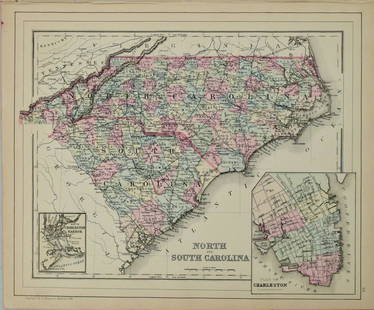
Sold20191867 NORTH + SOUTH CAROLINA MAPOriginal antique map of North and South Carolina published by S. Augustus Mitchell, Jr. Includes inset maps of Charleston Harbor in the bottom left and a Plan of Charleston in the bottom right. It feaSee Sold Price
Sold20221877 Mitchell Map of North and South Carolina -- North and South CarolinaTitle: 1877 Mitchell Map of North and South Carolina -- North and South Carolina Cartographer: S Mitchell Date/Place: 1877 Philadelphia Dimensions: 10.5 x 13.5 in. Description: This is an excellent anSee Sold Price
Sold20211887 Mitchell Map of North and South Carolina -- NorthTitle: 1887 Mitchell Map of North and South Carolina -- North and South Carolina Cartographer: S Mitchell Year / Place: 1887, Philadelphia Map Dimension (in.): 11.3 X 14 in. A very nice map of the CarSee Sold Price
Sold20211884 Mitchell Map of North and South Carolina -- NorthTitle: 1884 Mitchell Map of North and South Carolina -- North and South Carolina Cartographer: S Mitchell Year / Place: 1884, Philadelphia Map Dimension (in.): 11.3 X 14 in. This is a very nice map ofSee Sold Price
Sold20181876 Mitchell Map of North and South Carolina -- NorthReserve Reduced! Title/Content of Map: 1876 Mitchell Map of North and South Carolina -- North and South Carolina Date: 1876 Philadelphia Cartographer: S Mitchell Size: 10.5 x 13.5 in. Excellent and hiSee Sold Price
Sold20211867 Johnson Map of North and South Carolina --Title: 1867 Johnson Map of North and South Carolina -- Johnson's North and South Carolina Cartographer: A Johnson Year / Place: 1867, New York Map Dimension (in.): 17.3 x 24 in. This is an excellent,See Sold Price
20201867 Johnson Map of North and South Carolina --Title/Content of Map: 1867 Johnson Map of North and South Carolina -- Johnson's North and South Carolina Cartographer: A Johnson Year/Place: 1867, New York Size: 17.3 x 24 in. This is an excellent, laSee Sold Price
Sold2017Mitchell: Antique Map of Florida & South Carolina, 1860Map: 1860 Mitchell Map of Florida and South Carolina -- County Map of Florida [on sheet with] County Map of South Carolina Date Printed: 1860, Philadelphia Cartographer: S Mitchell Size: 9.1 x 10.6 inSee Sold Price
Sold20191860 Mitchell Map of Florida and South Carolina --Title/Content of Map: 1860 Mitchell Map of Florida and South Carolina -- County Map Of Florida [on sheet with] Map Of South Carolina Date: 1860, PhiladelphiaCartographer: S Mitchell Size: 10.8 x 13.2See Sold Price
Sold20231891 Mitchell Map of Maryland, Virginia, North Carolina and South Carolina -- Map of Maryland,Title: 1891 Mitchell Map of Maryland, Virginia, North Carolina and South Carolina -- Map of Maryland, Virginia, North Carolina and South Carolina Cartographer: S Mitchell Year/Place: 1891, PhiladelphiSee Sold Price
Sold2018North Carolina & South Carolina by MitchellTitle/Content of Map: North Carolina & South Carolina by Mitchell Date: 1869 Cartographer: Augustus S. Mitchell Material/Medium: Paper Size: 14" x 16" Provenance: New York Published in Philadelphia inSee Sold Price
Sold2017Johnson’s Civil War era map of North & South CarolinaHistoric map shows the Carolinas in great detail shortly following the outbreak of the Civil War. States hand-colored at the time of publishing with color coding according to county. Inset map depictsSee Sold Price
Sold2017Johnson: Map of North & South Carolina, 1864Map: 1864 Johnson Map of North and South Carolina Maker: Johnson and Ward Published: 1864, New York Size: 17.3 X 23.8 in. Excellent and highly detailed map of the Carolinas, showing the counties colorSee Sold Price
5 days LeftBrunk AuctionsJohn Mitchell - A Map of the British and French Dominions in North America, 1755-1757$24,000
2 days LeftJasper52Novae insulae. The New World. North & South America. SEBASTIAN MÜNSTER 1572 map$5,500
24 hrs LeftJasper52Map Accompanying Reports of the Artesian Wells Investigation [in North and South Dakota]$80
15 hrs LeftRapid Estate Liquidators and Auction GalleryVintage North And South Carolina Souvenir Porcelain Bells$30
5 days LeftBrunk Auctions1764 Contract Between Joseph Hewes, Samuel Johnston, Samuel Swift, and John Harvey$1,500
5 days LeftBrunk AuctionsExceptionally Rare Price-Strother Survey of North Carolina Map, c. 1808$60,000
5 days LeftConestoga Auction Company Division of Hess Auction GroupAntique Southern Pottery Alkaline Glazed Jar.$100
Oct 11Austin Auction Gallery(2) MITCHELL GOLD + BOB WILLIAMS LEATHER UPHOLSTERED CHAIR & OTTOMAN SET$300
Oct 11Austin Auction Gallery(2) MITCHELL GOLD + BOB WILLIAMS LEATHER UPHOLSTERED CHAIR & OTTOMAN SET$300
5 days LeftLink Auction GalleriesDorothy (Dottie) Goodman, North Carolina (1926-2001), Snow in Haywood County, 1986, acrylicl on$125
24 hrs LeftJasper521874 Mitchell Map of Mississippi, Louisiana and Arkansas -- County Map of the States of Arkansas$40


![Mitchell: Antique Map of Florida & South Carolina, 1860: Map: 1860 Mitchell Map of Florida and South Carolina -- County Map of Florida [on sheet with] County Map of South Carolina Date Printed: 1860, Philadelphia Cartographer: S Mitchell Size: 9.1 x 10.6 in](https://p1.liveauctioneers.com/5584/109294/56069180_1_x.jpg?height=310&quality=70&version=1505338533)
![1860 Mitchell Map of Florida and South Carolina --: Title/Content of Map: 1860 Mitchell Map of Florida and South Carolina -- County Map Of Florida [on sheet with] Map Of South Carolina Date: 1860, PhiladelphiaCartographer: S Mitchell Size: 10.8 x 13.2](https://p1.liveauctioneers.com/5584/144953/73284299_1_x.jpg?height=310&quality=70&version=1562102885)


![Map Accompanying Reports of the Artesian Wells Investigation [in North and South Dakota] (1 of 4)](https://p1.liveauctioneers.com/5584/343693/186665649_1_x.jpg?height=282&quality=70&version=1726603887)


![[SLAVERY] Free Black Man Illegally Deals w/ Slave (1 of 2)](https://p1.liveauctioneers.com/7226/343679/186654953_1_x.jpg?height=282&quality=70&version=1726238840)


