Sold2018Middle With Part of the Southern & Western States.Reserve Reduced! Item: Middle With Part of the Southern & Western States. Date: 1839 Cartographer: SHERMAN, GEORGE EDWARD Publisher: S.G. GOODRICH Size (inches): 17.5X10.75 Detailed school atlas map.See Sold Price
Sold2021(8) Vols. leather binding, incl. Historic Towns(8) Vols. leather binding, incl. Historic Towns, Includes: (4) vols. Historic Towns of the Southern States, Middle States, Western States & New England, Putnam's 1899-1901; (2) vols. Harvard College TSee Sold Price
Sold2019Cornell's Geography (1855), "Mexico, Northern orCornell's Geography (1855), "Mexico, Northern or Middle States, Southern and Western Sides, Yucatan, Balize, America and Central America," H.- 13 1/2 in., W.- 21 1/2 in.See Sold Price
Sold2017Mitchell: Antique Map of Southern States, US, 1858MAP of SOUTHERN STATES & PART WESTERN U.S. NC SC GA FL AL TN LA AK MS. Circa 1858 Antique Map. No. 12 - MAP OF THE CHIEF PART OF THE SOUTHERN STATES AND PART OF THE WESTERN. Engraved to Illustrate MitSee Sold Price
Sold20181839 Mitchell Map of New York to North Carolina -- No.Title/Content of Map: 1839 Mitchell Map of New York to North Carolina -- No. 11 Map of the Middle States and Part of Southern… Date: 1839 Philadelphia Cartographer: S Mitchell Size: 16.8 x 10.4 in.See Sold Price
Sold2019Three Copies of Samuel Augustus Mitchell (1790-1868),Three Copies of Samuel Augustus Mitchell (1790-1868), "Map of the Chief part of the Southern States and Part of the Western States," 1851, H. - 15 1/8 in., W. -23 in. (3 Pcs.)See Sold Price
Sold20241887 Appletons' General Guide to the United State and Canada Part II1887 Appletons' General Guide to the United State and Canada Part IIPart II. Western and Southern States of Appletons' General Guide, illustrated with over 550 pages of railway maps, plans of cities,See Sold Price
Sold2018Mitchell: Antique Map of New York to North CarolinaTitle/Content of Map: 1852 Mitchell Map of New York to North Carolina -- No. 11 Map of the Middle States and Part of Southern… Date Printed: 1852 Philadelphia Cartographer: S Mitchell / CowperthwaitSee Sold Price
Sold20201839 Maps, Middle States, Burgess, MitchellTwo hand colored maps, both dated 1839: "Map of the Middle States and part of the Southern, Engraved to Illustrate Mitchells School and family Geography" by S. Augustus Mitchell, engraved by J. H. YouSee Sold Price
Sold20231858 Mitchell Map of New York to North Carolina -- No. 11 Map of the Middle States and Part of theTitle: 1858 Mitchell Map of New York to North Carolina -- No. 11 Map of the Middle States and Part of the Southern… Cartographer: S Mitchell Year / Place: 1858, Philadelphia Map Dimension (in.):See Sold Price
Sold20181852 Mitchell Map of the US South -- No. 12 Map of theReserve Reduced! Title/Content of Map: 1852 Mitchell Map of the US South -- No. 12 Map of the Chief Part of the Southern States and Part of the Western… Date: 1852, Philadelphia Cartographer: S MitcSee Sold Price
Sold20231852 Mitchell Map of Southern US -- No 12 Map of the Chief Part of the Southern States and Part ofTitle: 1852 Mitchell Map of Southern US -- No 12 Map of the Chief Part of the Southern States and Part of the Western... Cartographer: S Mitchell Year / Place: 1852, Philadelphia Map Dimension (in.):See Sold Price
Sold2018Mitchell: Antique Map of Southern United States, 1852Title/Content of Map: 1852 Mitchell Map of Southern United States -- No. 12 Map of the Chief Part of the Southern States and Part of the Western... Date Printed: 1852 Philadelphia Cartographer: S MitcSee Sold Price
Sold20201858 Mitchell Map of Southern United States -- No. 12Title/Content of Map: 1858 Mitchell Map of Southern United States -- No. 12 Map of the Chief Part of the Southern States and Part of the Western... Date: 1858, Philadelphia Cartographer: S Mitchell SiSee Sold Price
Sold20211843 Geological Map of the Middle and Western StatesBy: James HallDate: 1843 (published)Dimensions: 23 x 32 inches (58.5 x 81 cm)This is a beautifully colored geological lithograph map by the iconic American geologist James Hall. The map covers most orSee Sold Price
Sold2021Southern and Western States, Designed to AccompanyPublication Date: 1855Title: Southern and Western States, Designed to Accompany Cornell's High School Geography Cartographer: CORNELL, S.S. Publisher: APPLETON, D. Height: 20 Width: 12 Map designatingSee Sold Price
Sold2023The Life of Sile Doty: The Most Noted Thief and Daring Burglar of His Time. The Leader of a Gang ofThe Life of Sile Doty: The Most Noted Thief and Daring Burglar of His Time. The Leader of a Gang of Counterfeiters, Horse Thieves and Burglars of the New England, Middle and Western States. The TerrorSee Sold Price
Sold2023Field Guide To Revenue Stamped Paper [157120]Includes the entire series from Part I Western States to Part 7 stocks, bonds and Railroad tickets. Compiled by Castenholz. The go to reference for everything Revenue Stamped Paper! All told about 900See Sold Price
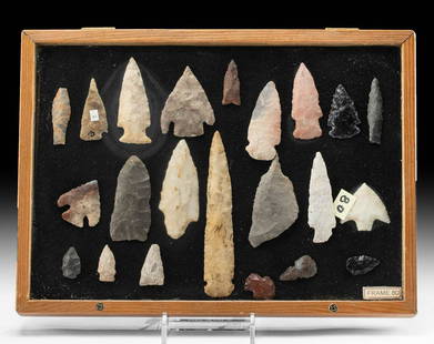
Sold202122 Native American Stone Projectile PointsNative American, Southern to Western United States, Archaic to Woodland period, ca. 8000 BCE to 1600 CE (10000 BP to 400 BP). A fabulous collection of 22 hand-knapped stone tools and projectile pointsSee Sold Price
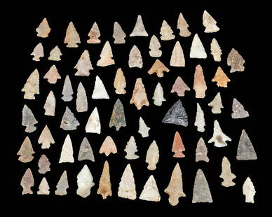
Sold202163 Native American Archaic & Woodlands ArrowheadsNative American, Southern to Western United States, Archaic to Woodland period, 2000 BCE to 1800 CE (4000 to 200 BP). A great collection of 63 stone projectile points; a diverse assortment which incluSee Sold Price
Sold2018Group of four engraved maps in one frame including No.Group of four engraved maps in one frame including No. 13 Map of the State of Texas by Mitchells; Texas; Southern States, Western Section; and Map of Louisiana, Texas, and Arkansas, each map ss 9" x 1See Sold Price
Sold2022Early 1839 school atlas map of Western StatesNice school atlas map of what was considered the West in 1839. No. 14 map of the Chief Part of the Western States by S. Augustus Mitchell. Contains a wealth of information such as rivers, towns, railrSee Sold Price
Sold2023Eighteen Southern Railroad Timetables - 1914 to 1967 - The Katy Railroad, Frisco, Kansas CityA group of eighteen southern and western United States railroad timetables spanning 1914 to 1967. Timetables for the Katy Railroad include an early table dated 1914 and later tables dated 1960 and 196See Sold Price
Sold20211852 Mitchell Map of Midwest United States and KentuckyTitle: 1852 Mitchell Map of Midwest United States and Kentucky -- No. 14 Map of the Chief Part of the Western States including Western Virginia Cartographer: S Mitchell / Cowperthwait & Co. Year / PlaSee Sold Price
4 days LeftJasper52Amér Mér Colombie & Brésil 9 Peru Colombia Amazonas Brazil VANDERMAELEN 1827 map$70
4 days LeftJasper52Partie méridionale Du Bresil… River Plate basin Brazil Uruguay. BONNE 1780 map$25
4 days LeftJasper52Extremité Meridionale de l'Amérique Tierra del Fuego Magellan Str BONNE 1788 map$35
633 Lots AwayKey Date CoinsSealed 2004 United States Mint Set in Original Government Shipped Box, Never Opened! 22 Coins$50
2 days LeftKey Date CoinsSealed 2004 United States Mint Set in Original Government Shipped Box, Never Opened! 22 Coins$50
3 days LeftRapid Estate Liquidators and Auction GalleryAntique Revolutionary War Hardcovers By William James 2 Volumes$2,000
Jun 08Leon GalleryGiovanni Battista Ramusio (1485 - 1557) Giacomo Gastaldi (1500 - 1566) - Terza Ostro Tavola (The₱1,300,000
Jun 02Carlsen Gallery, Inc.ALBUM INC. 36 CONFEDERATE NOTES, 8 SOUTHERN STATES NOTES, 8 RR NOTES, TICKETS, ETC$275(2 bids)
6 days LeftSelkirk Auctioneers & AppraisersCHARLOTTE SOUTHERN STATES FAIR - AUTO RACES ADVERTISING BROADSIDE$25
Jun 22Check the Oil Promotions, LLCBeeline Western States One Quart Motor Oil Can with Bumblebee Graphics$25(1 bid)


![Field Guide To Revenue Stamped Paper [157120]: Includes the entire series from Part I Western States to Part 7 stocks, bonds and Railroad tickets. Compiled by Castenholz. The go to reference for everything Revenue Stamped Paper! All told about 900](https://p1.liveauctioneers.com/2699/274471/144093105_1_x.jpg?height=310&quality=70&version=1673025700)