Sold2021Southern and Western States, Designed to AccompanyPublication Date: 1855Title: Southern and Western States, Designed to Accompany Cornell's High School Geography Cartographer: CORNELL, S.S. Publisher: APPLETON, D. Height: 20 Width: 12 Map designatingSee Sold Price
Sold20221839 Stiles, Sherman and Smith Map of Midwest United States and Kentucky -- Map of the WesternTitle: 1839 Stiles, Sherman and Smith Map of Midwest United States and Kentucky -- Map of the Western States Designed to Accompany Smith's Geography for Schools Cartographer: Stiles, Sherman and SmithSee Sold Price
Sold2019Map of the Southern StatesTitle: Map of the Southern States Publication Date: 1844 Cartographer: SMITH, ROSWELL C.? Publisher: DANIEL BURGESS Size: 10.5Height - 17.6Width Designed to accompany Smith's Geography for Schools. InSee Sold Price
Sold2016[Civil War; Map] History of the War [1864]Bishop, John S., Capt.: A CONCISE HISTORY OF THE WAR. DESIGNED TO ACCOMPANY PERRINE'S NEW WAR MAP OF THE SOUTHERN STATES.... Indianapolis. [1864]. 132, xi, [1] pp. plus large folding map. 5.75" x 3.75See Sold Price
Sold2018Middle With Part of the Southern & Western States.Reserve Reduced! Item: Middle With Part of the Southern & Western States. Date: 1839 Cartographer: SHERMAN, GEORGE EDWARD Publisher: S.G. GOODRICH Size (inches): 17.5X10.75 Detailed school atlas map.See Sold Price
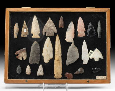
Sold202122 Native American Stone Projectile PointsNative American, Southern to Western United States, Archaic to Woodland period, ca. 8000 BCE to 1600 CE (10000 BP to 400 BP). A fabulous collection of 22 hand-knapped stone tools and projectile pointsSee Sold Price
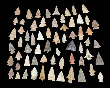
Sold202163 Native American Archaic & Woodlands ArrowheadsNative American, Southern to Western United States, Archaic to Woodland period, 2000 BCE to 1800 CE (4000 to 200 BP). A great collection of 63 stone projectile points; a diverse assortment which incluSee Sold Price
Sold2018Group of four engraved maps in one frame including No.Group of four engraved maps in one frame including No. 13 Map of the State of Texas by Mitchells; Texas; Southern States, Western Section; and Map of Louisiana, Texas, and Arkansas, each map ss 9" x 1See Sold Price
Sold2023Eighteen Southern Railroad Timetables - 1914 to 1967 - The Katy Railroad, Frisco, Kansas CityA group of eighteen southern and western United States railroad timetables spanning 1914 to 1967. Timetables for the Katy Railroad include an early table dated 1914 and later tables dated 1960 and 196See Sold Price
Sold2019W. Williams, "The Southern and South-Western StatesW. Williams, "The Southern and South-Western States (inset – Texas & inset – map of Eastern Virginia), 1849, H. - 13 in., W. - 18 1/2 in.See Sold Price
Sold2021(8) Vols. leather binding, incl. Historic Towns(8) Vols. leather binding, incl. Historic Towns, Includes: (4) vols. Historic Towns of the Southern States, Middle States, Western States & New England, Putnam's 1899-1901; (2) vols. Harvard College TSee Sold Price
Sold2024Early Native American Kiowa Beaded Leather LeggingsNative American, Western United States, Southern Plains, Kiowa culture, ca. late 19th to early 20th century CE. A pair of leggings made from leather with a lengthy fringe and beadwork along the ankleSee Sold Price
Sold2021Native American Stone Tool w/ Half Groove**Originally Listed At $250** Native American, Western United States, Southern Wyoming, Plains Tribes, ca. 200 to 1000 CE. A hand-carved half-groove stone tool with an elongated ovoid body. A groove rSee Sold Price
Sold2021Native American Stone Tool w/ Full Groove**Originally Listed At $200** Native American, Western United States, Southern Wyoming, Plains Tribes, ca. 200 to 1000 CE. A hand-carved full groove stone tool with an elongated ovoid body. A groove eSee Sold Price
Sold2019Texas. California.Title: Texas. California. Publication Date: 1866 Cartographer: WELLS, E. Publisher: D. APPLETON & CO. Dimension: 10Height - 12.5Width On reverse, Western Division of the United States. Designed to accSee Sold Price
Sold2017Mitchell: Antique Map of Southern States, US, 1858MAP of SOUTHERN STATES & PART WESTERN U.S. NC SC GA FL AL TN LA AK MS. Circa 1858 Antique Map. No. 12 - MAP OF THE CHIEF PART OF THE SOUTHERN STATES AND PART OF THE WESTERN. Engraved to Illustrate MitSee Sold Price
Sold20241887 Appletons' General Guide to the United State and Canada Part II1887 Appletons' General Guide to the United State and Canada Part IIPart II. Western and Southern States of Appletons' General Guide, illustrated with over 550 pages of railway maps, plans of cities,See Sold Price
Sold2019Cornell's Geography (1855), "Mexico, Northern orCornell's Geography (1855), "Mexico, Northern or Middle States, Southern and Western Sides, Yucatan, Balize, America and Central America," H.- 13 1/2 in., W.- 21 1/2 in.See Sold Price
Sold20188 Timetables & Travel Folders from the WestA group of 8 travel folders and timetables from Western States: California Limited 1916, Southern Pacific 1908, Northern Pacific Expo 1915, Union Pacific Colorado 1888, Santa Fe Arizona Apache trail,See Sold Price
Sold2016Antique US Map of Territories & Pacific States, 1865Domestic: Free ShippingItem: Old Antique Map of the Western United StatesTitle: Territories & Pacific States to Accompany "Across the Continent" by Samuel BowlesEngraver: J.H. GoldtwhaitPrinter: G.W.See Sold Price
Sold2019Three Copies of Samuel Augustus Mitchell (1790-1868),Three Copies of Samuel Augustus Mitchell (1790-1868), "Map of the Chief part of the Southern States and Part of the Western States," 1851, H. - 15 1/8 in., W. -23 in. (3 Pcs.)See Sold Price
2016Antique US Map of Territories & Pacific States, 1865Domestic: Free Shipping Item: Old Antique Map of the Western United States Title: Territories & Pacific States to Accompany "Across the Continent" by Samuel Bowles Engraver: J.H. Goldtwhait Printer: GSee Sold Price
Sold20191872 Warner Beers Map Western Portion of SouthernReserve Reduced! Title/Content of Map: 1872 Warner Beers Map Western Portion of Southern States -- County Map of Tennessee, Kentucky, Alabama. Mississippi, Arkansas and Louisiana Date: 1872, Chicago CSee Sold Price
Sold2019Western States Timetables - 11A group of public timetables from Western States: Western Pacific 1911, Northern Pacific 1907, Union Pacific 1903, Southern Pacific '07 & '14, Rock Island 1909, Frisco 1919, CB&Q '09 & '26, 2 MilwaukeSee Sold Price
6 days LeftCarlsen Gallery, Inc.ALBUM INC. 36 CONFEDERATE NOTES, 8 SOUTHERN STATES NOTES, 8 RR NOTES, TICKETS, ETC$275(2 bids)
4 days LeftSelkirk Auctioneers & AppraisersCHARLOTTE SOUTHERN STATES FAIR - AUTO RACES ADVERTISING BROADSIDE$25
Jun 22Check the Oil Promotions, LLCBeeline Western States One Quart Motor Oil Can with Bumblebee Graphics$50(2 bids)
Featured2 days LeftJasper52SOUTHERN MEXICO & CENTRAL AMERICA. Yucatan Belize Mosquito Coast.SDUK 1844 map$35
2 days LeftJasper52SOUTHERN MEXICO & CENTRAL AMERICA. Yucatan Belize Mosquito Coast. SDUK 1846 map$25
2 days LeftJasper52SOUTH AMERICA. 'La Plata, Chili, Paraguay, Uruguay & Patagonia'. LOWRY 1862 map$35
Jun 08Early American History Auctions1862 Civil War Dated, Union General David Hunter Autograph Letter Signed Involving 3 Union Generals$600
2 days LeftJasper52Partie méridionale Du Bresil… River Plate basin Brazil Uruguay. BONNE 1780 map$25


![[Civil War; Map] History of the War [1864]: Bishop, John S., Capt.: A CONCISE HISTORY OF THE WAR. DESIGNED TO ACCOMPANY PERRINE'S NEW WAR MAP OF THE SOUTHERN STATES.... Indianapolis. [1864]. 132, xi, [1] pp. plus large folding map. 5.75" x 3.75](https://p1.liveauctioneers.com/3532/91776/46880401_1_x.jpg?height=310&quality=70&version=1469669287)