Sold20191887 Page Co. Map of Texas -- Map of TexasReserve Reduced! Title/Content of Map: 1887 Page Co. Map of Texas -- Map of Texas Date: 1887 Chicago Cartographer: H. R. Page & Co. Size: 26 X 16.5 in. This large Texas map is a rare issue by the littSee Sold Price
Sold2023[Texas.] Rand, McNally & Co.'s New 11 X 14 Map of Texas.Publication Date: ©1901 Title: [Texas.] Rand, McNally & Co.'s New 11 X 14 Map of Texas. Cartographer: Rand, McNally & Co. Publisher: Rand, McNally & Co. Height: 9.25 Width: 12.5 Page 55 from RandSee Sold Price
Sold20201887 Page Co. Map of Kansas -- KansasTitle/Content of Map: 1887 Page Co. Map of Kansas -- Kansas Cartographer: H.R. Page & Co. Year/Place: 1887 Chicago Size: 16.1 X 24.6 in. This is an excellent and large map of Kansas, 26 years after adSee Sold Price
Sold2023Huge map of Texas in fine condition from scarce atlasA map that will not show up in many collections of Texas maps. Extremely large 2-page map of Texas from the very scarce 1894 Potter-Bradley atlas. This is the last atlas published with hand-colored maSee Sold Price
Sold20201887 Cram Map of Texas [verso] Indian Territory [verso]Title/Content of Map: 1887 Cram Map of Texas [verso] Indian Territory [verso] Arkansas -- Texas [verso] Indian Ty. [verso] Arkansas Date: 1887, Chicago Cartographer: G Cram Size: 12 X 17 in. This is aSee Sold Price
Sold2022(TEXAS.) Joseph Hutchins Colton. New Map of the State of Texas Compiled from J. de Cordova's Large(TEXAS.) Joseph Hutchins Colton. New Map of the State of Texas Compiled from J. de Cordova's Large Map. Double-page lithographed map of Texas with attractive original hand-color by county. 18x27 incheSee Sold Price
Sold20221885 Two-page Railroad map of TexasCram’s 1885 double-page railroad map of Texas has exceptional printed color. Every railroad line in the state is highlighted in a heavier black line than such things as county borders, rivers anSee Sold Price
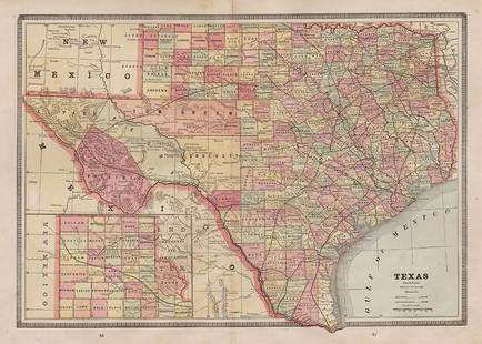
Sold2017Mitchell: Antique County Map of Texas, 1873Excellent 1873 County Map of Texas by S. Augustus Mitchell. Impressive two-page County Map of the State of Texas. Map image much larger than earlier Mitchell maps. Designed and engraved by W. H. GamblSee Sold Price
Sold2017Cram: Antique Map of Texas, 1887Title: Map of Texas by Cram Date: 1887 Medium: Wax Engraving Dimensions (in.): 14.5 x 22 George F. Cram (1842-1928) served in the U.S. Army during the American Civil War. After the war ended, Cram joiSee Sold Price
Sold2020CAREY, HENRY CHARLES; and LEA, ISAAC. Geographical,CAREY, HENRY CHARLES; and LEA, ISAAC. Geographical, Statistical, and Historical Map of Mexico. Double-page engraved map of Mexico, Texas, and parts of the southwestern United States with border panelsSee Sold Price
Sold2022Scarce 1st ed. Northern Texas/Indian Territory, Tunison 1885Beautiful and scarce double-page chromolithographic map of Northern Texas and Indian Territory. From the 1885 edition of Tunison’s Peerless Universal Atlas of the World. WorldCat lists this atlaSee Sold Price
Sold2024A Texas Map Circa 1890A VINTAGE MAP, "Texas," CIRCA 1890, engraving on paper, a page fragment from an atlas (vertical fold line down center), plate 68, with view of the Panhandle, lacking Jeff Davis County, within a geometSee Sold Price
Sold2021A REPUBLIC OF TEXAS MAP, "Méxique," THUNOT DUVOTENAY,A REPUBLIC OF TEXAS MAP, "Méxique," THUNOT DUVOTENAY, PARIS, CIRCA 1843, hand-colored lithograph on paper, Thunot Duvotenay, French cartographer, Charles Smith, English plate engraver, a page fragmeSee Sold Price
Sold2022Scarce Texas map (western part) from Asher & AdamsLarge double-page map of Western Portion of Texas with inset of extreme western tip of the state. Shows towns, proposed railroad lines and river, including the Colorado River and the Rio Grande. The fSee Sold Price
Sold2020TEXAS MAP ENGRAVING PANHANDLE COUNTIES INSETFramed Texas map, hand-colored engraving on paper, a page from an atlas, plate 68, published by William Bradley, c.1880, an inset with Panhandle counties, within a geometric border, sight: approx 17.5See Sold Price
Sold2018Map of Texas Oil Drilling Sites"Gallup's Map of Texas, Published by F.E. Gallup Map Co." Sight size: 20-1/2"h x 29"w Provenance: Bought from rare book sealer in Santa Fe, New Mexico.See Sold Price
Sold2021Very scarce Southern Texas, Cram 1882Scarce double-page hand-colored map of Southern Texas from the very early and scarce 1882 Cram’s Unrivaled Family Atlas of the World. All Cram atlases prior to 1883 are extremely scarce. They arSee Sold Price
Sold20221866 McNally Map of Texas -- TexasTitle: 1866 McNally Map of Texas -- Texas Cartographer: McNally & Co. Year / Place: 1866, New York Map Dimension (in.): 8.3 X 10.6 in. This is an outstanding and seldom seen map of Texas from just 21See Sold Price
Sold20231864 Johnson Map of Texas -- Johnson's New Map of the State of TexasTitle: 1864 Johnson Map of Texas -- Johnson's New Map of the State of Texas Cartographer: Johnson & Ward Year / Place: 1864, New York Map Dimension (in.): 16.7 X 24.5 in. Thisis a double page, superbSee Sold Price
Sold20221st ed. near pristine McNally map of Texas & Ind. Terr., 1881Highly detailed and scarce large format railroad map, one of the best of the period. Rand, McNally & Co.’s Texas and Indian Territory, dated 1881 (first edition). This great map depicts railroadSee Sold Price
Sold20241863 Johnson Map of Texas -- Johnson's New Map of the State of TexasDescriptionTitle: 1863 Johnson Map of Texas -- Johnson's New Map of the State of TexasCartographer: Johnson & WardYear / Place: 1863, New YorkMap Dimension (in.): 16.2 X 24.1 in.Thisis a double page,See Sold Price
2017Colton: Map of Texas, 1855Map: Texas Cartographer: J. H. Colton Illustrator: J. H. Colton Edition: First Edition Publisher: J. H. Colton, Co. Published: New York, 1855 Size: 12.75 x 15.5 inches Counties current to 1854 makingSee Sold Price
Sold2024Reproduction Map of TexasReproduction of 1855 map of Texas, originally published J.H.Colton and Co. (New York), resting on board, sealed in plastic height 17.75 in. x width 19.5 in. x depth 0 in. Condition: Handwritten "See Sold Price
Sold20201886 Cram Map of Texas [verso] Indian Territory [verso]Title/Content of Map: 1886 Cram Map of Texas [verso] Indian Territory [verso] Arkansas -- Texas [verso] Indian Ty. [verso] Arkansas Cartographer: G Cram /People's Publishing Co. Year/Place: 1886, ChicSee Sold Price
15 hrs LeftRapid Estate Liquidators and Auction GalleryVintage Offical Street Guides Iowa New York$45
2 days LeftJasper521874 Mitchell Map of Texas, Louisiana and Arkansas -- Map of Louisiana, Texas, Arkansas$65
Nov 03Modern JewelryNEW 14K YELLOW GOLD TEXAS STATE MAP PENDANT 14K YELLOW GOLD NEW TEXAS STATE MAP PENDANT WEIGHT: 2g$260
5 days LeftTrillium Antique Prints & Rare BooksDe L'Isle - Map of Louisiana and the Course of the Mississippi (Eastern America) (First Appearance$240(2 bids)
Featured2 days LeftJasper52No. 13 Map of the State of Texas Engraved to Illustrate Mitchell's School and Family Geography$55
Featured1 day LeftJasper52FOR THE LIBERTY OF TEXAS Edw. Stratemeyer 1909 HC Lothrop Lee Shepard Excellent$160
Oct 12JM Hobby Supply and Railroad Artifact AuctionsToledo St Louis and Kansas City RR First Mortgage Gold Bond-1887$10
Oct 12JM Hobby Supply and Railroad Artifact AuctionsLouisville and Nashville RR 1896 Route Map and Letter$20
Oct 18Rail & Road Auctions1878 Maps of the New and Popular St. Louis and Texas Short Line Railroad Color Lithograph$40(1 bid)
2 days LeftJasper52Austria-Hungary Rand, McNally & Co.'S Indexed Atlas of the World Map of Austria-Hungary.$70
2 days LeftJasper52Rand, McNally & Co.'S Indexed Atlas of the World Map of Germany (Western Sheet). | (Eastern Sheet).$60
Oct 12JM Hobby Supply and Railroad Artifact AuctionsNorthern Pacific RR Routes Resources Progress and Business Book-February 1871 $5


![[Texas.] Rand, McNally & Co.'s New 11 X 14 Map of Texas.: Publication Date: ©1901 Title: [Texas.] Rand, McNally & Co.'s New 11 X 14 Map of Texas. Cartographer: Rand, McNally & Co. Publisher: Rand, McNally & Co. Height: 9.25 Width: 12.5 Page 55 from Rand](https://p1.liveauctioneers.com/5584/285598/150695081_1_x.jpg?height=310&quality=70&version=1681855790)


![1887 Cram Map of Texas [verso] Indian Territory [verso]: Title/Content of Map: 1887 Cram Map of Texas [verso] Indian Territory [verso] Arkansas -- Texas [verso] Indian Ty. [verso] Arkansas Date: 1887, Chicago Cartographer: G Cram Size: 12 X 17 in. This is a](https://p1.liveauctioneers.com/5584/164510/83043299_1_x.jpg?height=310&quality=70&version=1585094571)


![1886 Cram Map of Texas [verso] Indian Territory [verso]: Title/Content of Map: 1886 Cram Map of Texas [verso] Indian Territory [verso] Arkansas -- Texas [verso] Indian Ty. [verso] Arkansas Cartographer: G Cram /People's Publishing Co. Year/Place: 1886, Chic](https://p1.liveauctioneers.com/5584/175972/88577718_1_x.jpg?height=310&quality=70&version=1597183226)


![[MAPS] DOUBLE-PAGE. LOT OF 4 SOLD TOGETHER (1 of 4)](https://p1.liveauctioneers.com/8124/343618/186530168_1_x.jpg?height=282&quality=70&version=1726178725)


