Sold2018Bellin: Chart of Santiago de Cuba HarborReserve Reduced! A detailed plan of the harbor of Santiago de Cuba, featuring forts, depth soundings, anchorages, the road from the forts to "la Ville de St. Yago," and a decorative title cartouche, fSee Sold Price
Sold2023MAP: Robert de Vaugondy "Plan de la Ville et des Faubourgs de Paris" map of Paris circa late 1700's,MAP: Robert de Vaugondy "Plan de la Ville et des Faubourgs de Paris" map of Paris circa late 1700's, folded into paper holder, 22 1/2" x 33"See Sold Price
Sold2020Group of Assorted Antique Maps of Vienna AustriaGroup of Assorted Antique Maps of Vienna, Austria including 'Plan de la Ville et des Fauxbourgs de Vienne,''Derivation du Danube pres de Vienne,' 'Erz~Herzogthum Oesterreich:Unter Der Enns 1853,' 'DieSee Sold Price
Sold2018Mondhare: Seven Years’ War British Siege of HavanaVue de la Prise des Forts et Ville de Havane par les Anglois en 1762 A dramatic view of the British siege of the forts and city of Havana, with lighters carrying troops who are about to scale the fortSee Sold Price
Sold20241812 large French map of Paris plan routier de la Ville et faubourgLarge engraving of Paris and its surrounding area dated 1812 , cooper engraving in the manner of the Turgot map ,Jean Pierre printer , a Paris, chez Jean, Rue St Jean de Beauvais, N° 10, It is thSee Sold Price
Sold2023Delisle Map of Paris, France, Hand Colored 1716Important Map of Paris by Guillaume De L'Isle, Full Title: Plan de la Ville et Fauxbourgs de Paris. Dressee sur les observations astronomiques de l'Academie Royale des Sciences et sur les operations gSee Sold Price
Sold2021ROME. City plan showing churches Colosseum Vatican StTITLE OF THE MAP: 'Plan et Porfil de la ville de Rome Moderne' The top image on the right hand side shows the entire map. To view a close up of the map showing the level of printed detail, please clicSee Sold Price
Sold2018Scarce chart of Madeleine Islands, CanadaHeading: (Canada) Author: Collins, Lieutenant Title: Golfe St.-Laurent. Îles de la Madeleine Place Published: [Paris, France] Publisher:Dépôt des cartes et plans de la marine Date Published:See Sold Price
Sold2022DEL RIO, JOSE Plan du Port et de la Ville de la Havanne leve en 1798. [Paris:] par Ordre du MinistreDEL RIO, JOSE Plan du Port et de la Ville de la Havanne leve en 1798. [Paris:] par Ordre du Ministre de la Marine et des Colonies, l'An IX de l'Ere Francaise, [circa 1800]. Engraved map with the "DepoSee Sold Price
Sold2016[BELGIQUE] Ottmar ELLIGER - Plan des lignes et campemen[BELGIQUE] Ottmar ELLIGER - Plan des lignes et campements des armées des alliez commandées par le roy de la Grande Bretagne devant la ville et chateau de Namur. A Amsteldam, Chez Nicolas VisscheSee Sold Price
Sold20171764 Map of Port At St. Vincent BellinCopper Plate Engraved Map “plan Du Port Et Du Carenage De Cariacoua Situe Dans La Partie Du Sud De L'isle De St. Vincent”, Bellin's "le Petit Atlas Maritime, Ou Recueil De Cartes Et De Plans Des QSee Sold Price
Sold2018Bellin: Antique Plan of Salvador da Bahia, Brazil, 1750Plan de la Ville de St. Salvador Bellin's superbly rendered and detailed plan of Salvador, at the time the capital of Brazil, from the atlas of Prevost d'Exiles' influential travel book, Histoire GeneSee Sold Price
Sold2019Bellin: Plan & View of Salvador da Bahia, BrazilTitle: Plan de la Ville de St. Salvador Cartographer: Bellin Place/Date: Paris / 1750/1760 Size: 11 3/4" x 7 1/2" Condition: b&w; light overall age toning; minor spotting and a light water stain in thSee Sold Price
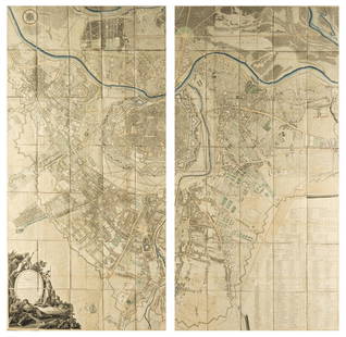
Sold2023Plan de la Ville et Fauxbourgs de ParisPlan de la Ville et Fauxbourgs de Paris, 1763 historic wall map of Paris, 1777 "Divise en 20 quartiers dont la plus grande partie a ete rectifiee" by Debarme paper size 60" x 70 1/2", frame size 62" xSee Sold Price
Sold2019Plan de la Ville et Forteresse de Malaca'. Malacca.TITLE/CONTENT OF MAP: 'Plan de la Ville et Forteresse de Malaca [Plan of the city and fortress of Malacca]' A Famosa Fortress, Malacca DATE PRINTED: 1753 IMAGE SIZE: Approx 21.5 x 15.5cm, 8.5 x 6.25 iSee Sold Price
Sold2016Large plan of Paris 1814Heading: Author: Bonnisel, J. Title: Plan de la Ville et Faubourgs de Paris avec ses Monuments… Place Published: Paris Publisher: Date Published: 1814 Description: EngravedSee Sold Price
Sold2021[MAPS] SÉBASTIEN DE PONTAULT, CHEVALIER DE[MAPS] SÉBASTIEN DE PONTAULT, CHEVALIER DE BEAULIEU. Plan de la Ville, et Chateau de Valence... Paris: circa 1690. 17 1/2 x 21 inches, hand-colored engraving. Usual folds, generally a clean exampSee Sold Price
Sold2017Bellin: Plan of Malacca City/Tonkin River Basin ChartMap: Plan de la Ville et Forteresse de Malaca [and on the same sheet] Carte du Cours de la Riviere de Tunquin [Tonkin] Depuis Cacho jusqu'a la Mer Cartographer: Bellin Place & Date: Paris / 1750/1760See Sold Price
Sold2023Esnauts (Jacques) Nouveau Plan Routier de la Ville et Faubourgs de Paris Avec ses Principaux EdificeEsnauts (Jacques) and Michel Rapilly. Nouveau Plan Routier de la Ville et Faubourgs de Paris Avec ses Principaux Edifices Par M. Pichon, large wall map of Paris, the border decorated with 28 vignettesSee Sold Price
Sold2019Plan de la ville et du port de Macao'. Macau town cityTITLE/CONTENT OF MAP: 'Plan de la Ville et du port de Macao [Plan of the City and Port of Macau]' The top image on the right hand side shows the entire map. To view a close up of the map showing the lSee Sold Price
Sold2018Austria.- Grimm (Maximilian von) Grundriss der Kl: Kl:Austria.- Grimm (Maximilian von) Grundriss der Kl: Kl: Haupt und Residenzstadt Wien mit ihren Vorstadten nach den Neuen Hausnumern 1797 / Plan de la Ville de Vienne et de ses Fouxbourgs avec le DenombSee Sold Price
Sold2016Plan of Paris 1803Heading: Author: Jean, Pierre Title: Plan Routier de la Ville et Faubourg de Paris, divisé en 12 municipalités Place Published: Paris Publisher:Chez Jean Date Published: 1803, An 11 DeSee Sold Price
Sold2020[MILITARY ARCHITECTURE] 9 plans together[Fortifications and Military Architecture.] A collection of nine maps sold together including Fer, Nicolas de. PLAN DE LA VILLE OUVRAGES ET CHTEAU DE NAMUR. Paris, [c. 1692] 36 x 51.5 cm. **And eightSee Sold Price
Sold20201749 Bellin Map of Macao/Macau -- Plan de la Ville etTitle: 1749 Bellin Map of Macao/Macau -- Plan de la Ville et du Port de Macao Cartographer: J Bellin Year / Place: 1749, Paris Map Dimension (in.): 8.3 X 6.6 in. This is an excellent plan of city andSee Sold Price
8 hrs LeftJeschke Jadi Auctions Berlin GmbHNouveau Plan illustré de la Ville de Paris avec le système complet de ses fortifications€300
4 days LeftJasper521714 Chatelain Map of Moscow with Coats of Arms -- Carte du Gouvernement Civil et Ecclesiastique de$240
14 hrs LeftNadeau's Auction GalleryPair of Michel-Francois Damame-Demartris (French 1763-1827)$150(1 bid)
3 days LeftL'Autographe LtdMUSIC - GOUNOD Charles Franois (1818 - 1893) - Autograph letter signed£200
8 hrs LeftJeschke Jadi Auctions Berlin GmbHCorrozet, Gilles Les Antiquitez, chroniques, et singularitez de Paris, ville capitale du Royaume de€1,500
2 days LeftClaydon Auctioneers LtdBook: De Buonaparte, des Bourbons, et de la necessite de se rallier a nos princes legitimes, pour le£50
3 days LeftL'Autographe LtdLITERATURE - MICHON Jean Hyppolyte (1806 - 1881) - Autograph letter signed£30
4 days LeftFlints Auctions LtdLacambre, George, Traité Complet de la Fabrication de Bières et de la£80
May 09TheRedFinch AuctionsKANDINSKY. Les Tendances Nouvelles n 26, 1906, 10 woodcuts by Kandinsky.$1,600
8 hrs LeftJeschke Jadi Auctions Berlin GmbHGassendi u. François Bernier, Pierre Abregé de la Philosophie de Mr Gassendi, contenant€800
8 hrs LeftJeschke Jadi Auctions Berlin GmbHSammlung von 7 gestoch. u. tls. kol. Karten. Verso tls. mit typogr. Text. 1 Karte in Punkten unter€400
17 hrs LeftRapid Estate Liquidators and Auction Gallery1890 Souvenirs des Guerres de Crimée et d'Italie$65


![Scarce chart of Madeleine Islands, Canada: Heading: (Canada) Author: Collins, Lieutenant Title: Golfe St.-Laurent. Îles de la Madeleine Place Published: [Paris, France] Publisher:Dépôt des cartes et plans de la marine Date Published:](https://p1.liveauctioneers.com/642/114967/59038243_1_x.jpg?height=310&quality=70&version=1515289950)
![DEL RIO, JOSE Plan du Port et de la Ville de la Havanne leve en 1798. [Paris:] par Ordre du Ministre: DEL RIO, JOSE Plan du Port et de la Ville de la Havanne leve en 1798. [Paris:] par Ordre du Ministre de la Marine et des Colonies, l'An IX de l'Ere Francaise, [circa 1800]. Engraved map with the "Depo](https://p1.liveauctioneers.com/292/250642/130213494_1_x.jpg?height=310&quality=70&version=1654271664)
![[BELGIQUE] Ottmar ELLIGER - Plan des lignes et campemen: [BELGIQUE] Ottmar ELLIGER - Plan des lignes et campements des armées des alliez commandées par le roy de la Grande Bretagne devant la ville et chateau de Namur. A Amsteldam, Chez Nicolas Vissche](https://p1.liveauctioneers.com/828/93130/47639054_1_x.jpg?height=310&quality=70&version=1472918018)


![Plan de la Ville et Forteresse de Malaca'. Malacca.: TITLE/CONTENT OF MAP: 'Plan de la Ville et Forteresse de Malaca [Plan of the city and fortress of Malacca]' A Famosa Fortress, Malacca DATE PRINTED: 1753 IMAGE SIZE: Approx 21.5 x 15.5cm, 8.5 x 6.25 i](https://p1.liveauctioneers.com/5584/138633/70306186_1_x.jpg?height=310&quality=70&version=1553637454)

![[MAPS] SÉBASTIEN DE PONTAULT, CHEVALIER DE: [MAPS] SÉBASTIEN DE PONTAULT, CHEVALIER DE BEAULIEU. Plan de la Ville, et Chateau de Valence... Paris: circa 1690. 17 1/2 x 21 inches, hand-colored engraving. Usual folds, generally a clean examp](https://p1.liveauctioneers.com/292/204169/103522320_1_x.jpg?height=310&quality=70&version=1621026354)
![Bellin: Plan of Malacca City/Tonkin River Basin Chart: Map: Plan de la Ville et Forteresse de Malaca [and on the same sheet] Carte du Cours de la Riviere de Tunquin [Tonkin] Depuis Cacho jusqu'a la Mer Cartographer: Bellin Place & Date: Paris / 1750/1760](https://p1.liveauctioneers.com/5584/105261/53910605_1_x.jpg?height=310&quality=70&version=1497542970)

![Plan de la ville et du port de Macao'. Macau town city: TITLE/CONTENT OF MAP: 'Plan de la Ville et du port de Macao [Plan of the City and Port of Macau]' The top image on the right hand side shows the entire map. To view a close up of the map showing the l](https://p1.liveauctioneers.com/5584/152091/76804722_1_x.jpg?height=310&quality=70&version=1571180311)

![[MILITARY ARCHITECTURE] 9 plans together: [Fortifications and Military Architecture.] A collection of nine maps sold together including Fer, Nicolas de. PLAN DE LA VILLE OUVRAGES ET CHTEAU DE NAMUR. Paris, [c. 1692] 36 x 51.5 cm. **And eight](https://p1.liveauctioneers.com/1124/187577/94368877_1_x.jpg?height=310&quality=70&version=1607095126)


![[Charles Darwin Interest] (1 of 5)](https://p1.liveauctioneers.com/3532/326332/175680592_1_x.jpg?height=282&quality=70&version=1713150771)


