Sold2019Chart Exhibiting the Discoveries of the SecondTitle: Chart Exhibiting the Discoveries of the Second American-Grinnell-Expedition Publication Date: 1855 Cartographer: KANE, ELISHA KENT/AUGUST SONNTAG Publisher: U.S. SENATE Size: 17.25Height - 14.7See Sold Price
Sold2023World: Captain Cook, Large Folio - A General Chart Exhibiting the Discoveries made by Captain JamesThis fascinating folio engraving is from Captain James Cook & James King's A Voyage to the Pacific Ocean, for making Discoveries in the Northern Hemisphere. To determine the Position and Extent of theSee Sold Price
Sold2018World chart with discoveries of James Cook 1787Heading: Author: Faden, William Title: A New General Chart of the World, Exhibiting the Whole of the Discoveries made by the late Captain James Cook, F.R.S. with the Tracks of the Ships under his ComSee Sold Price
2024A New & Accurate Chart of the Discoveries of Captn Cook… CONDER 1794 old mapTITLE OF MAP (NOT PRINTED ON THE PAGE):'A New & Accurate Chart of the Discoveries of Captn Cook & other Later Circumnavigators : Exhibiting the whole coast of New South Wales, shewing the situations oSee Sold Price
Sold2024A New & Accurate Chart of the Discoveries of Captn Cook… CONDER 1794 old mapTitle: A New & Accurate Chart of the Discoveries of Captn Cook… CONDER 1794 old map Description: A New & Accurate Chart of the Discoveries of Captn Cook & other Later Circumnavigators : Exhibiting tSee Sold Price
Sold2023Group of 4 1915 Classroon Picture Charts of United States HistoryIncludes our first second and third century, and the American continent- discoveries and explorations. Each measure 35 x 42 inchesSee Sold Price
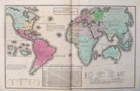
Sold20211835 Smith World Map -- A Chart Exhibiting the ActualTitle: 1835 Smith World Map -- A Chart Exhibiting the Actual and Comparative Size of each Country, Nation, or Kingdom; its Population as a Whole and to a Square Mile. Also the Different States of SociSee Sold Price
Sold2019Chart Exhibiting the Actual and Comparative Size ofTitle/Content of Map: Chart Exhibiting the Actual and Comparative Size of Each Country, Nation, Or Kingdom: Its Population As a Whole and to a Square Mile: Also the Different States of Society, FormsSee Sold Price
Sold2024Henry Bostwick, 1827, bound atlas "A Historical,Chronological and genealogical Chart" exhibiting maps of "Ancient Countries, as well as a new scale of time charts" developed by Bostwick including countries in the Mediterranean, Greece, France, andSee Sold Price
Sold2017Smith: Antique Map of the World, 1835Map: 1835 Smith World Map -- A Chart Exhibiting the Actual and Comparative Size of each Country, Nation, or Kingdom; its Population as a Whole and to a Square Mile. Also the Different States of SocietSee Sold Price
Sold2021Bird Identification by Audubon - Church and Dwight Co.There are two bird charts in this lot. The first is an Audubon Chart #3 at 27.5 x 44 inches published by the Massachusetts Audubon Society in 1912; informative and scientific. The second chart is prinSee Sold Price
Sold2019LOT OF 2: STORE CANDY SCALES.Two store candy scales, the first one is a small Jocobs Brothers 2lb Scale. An early operator overpaint, with original pan and clean chart. The second is a small Detecto-Gram counter balance scale, wiSee Sold Price
Sold20201798 La Perouse Map of Northwest Pacific from China toTitle: 1798 La Perouse Map of Northwest Pacific from China to Kamchatka -- Chart of Discoveries made in 1787 In the Seas of China & Tartary Between Manilla and Avatcha By the Boussole & Astrolabe CartSee Sold Price
Sold20201798 La Perouse Map of Northwest Pacific -- Chart ofTitle: 1798 La Perouse Map of Northwest Pacific -- Chart of Discoveries, made in 1787, in the Seas of China and Tartary, by the Boussole and Astrolabe, from their Leaving Manilla, to their arrival atSee Sold Price
Sold2019James Wyld (1812-1887, London), "Map of North AmericaJames Wyld (1812-1887, London), "Map of North America Exhibiting Recent Discoveries Geographical and Nautical," hand colored atlas page, H.- 23 in., W.- 17 in.See Sold Price
Sold2019Natural History - British Fluorite SpecimensTwo fluorite specimens, one displaying a matrix free, cloudy-transparent, deep green coloured crystal with bruising to one quoin, the second exhibiting pale mauve cubic crystals over white prismatic qSee Sold Price
Sold2016Scott - The Voyage of the "Discovery", 2 vol., second( Capt. Robert Falcon) The Voyage of the "Discovery", 2 vol., second impression, plates and maps, foxing, original cloth, rubbed, 1905; Scott's Last Expedition, 2 vol., second edition, plates and mapsSee Sold Price
Sold2019George Augustus Baldwyn's Universal Geography, "A NewGeorge Augustus Baldwyn's Universal Geography, "A New Accurate Chart of the Discoveries of Cap't Cook, the Whole Coast of New South Wales, Coast of North America, Pacific Ocean, Cap't. Bligh," H. - 18See Sold Price
Sold2020A Regency 22-Inch Terrestrial Floor Globe by John andA Regency 22-Inch Terrestrial Floor Globe by John and William Cary London, Early 19th Century labeled Cary's/ New/ Terrestrial Globe/ Exhibiting/ The Tracks and Discoveries made by/ Captain Cook/ AlsoSee Sold Price
Sold20191845 The Templar1845 The Templar's chart or, Hieroglyphic monitor Scarce second edition of the first illustrated guide to the organization, rituals, and symbolism of the Masonic Knights Templar for the General GrandSee Sold Price
Sold2022WORLD WAR I IRON CROSSES AND INSIGNIAPair of German World War I Iron Crosses and other insignia. The first example is in good condition, unmarked, in about average condition and still exhibiting good detail. The second example is on a paSee Sold Price
Sold2022(TRAVEL -- ARCTIC.) William Edward Parry. Journal of a Second Voyage for the Discovery of a(TRAVEL -- ARCTIC.) William Edward Parry. Journal of a Second Voyage for the Discovery of a North-West Passage from the Atlantic to the Pacific; Performed in the Years 1821-22-23 in His Majesty's ShipSee Sold Price
Sold2023James Cook Antiquated MapAntiquated framed and glazed map / 'agenera chart' depicting the voyages and discoveries of Captain James Cook height 28 in. x width 42 in. x depth 1.5 in. We happily provide seamless shippiSee Sold Price
Sold20211821 Woodbridge Thematic World Map of Type ofTitle: 1821 Woodbridge Thematic World Map of Type of Inhabitation -- Chart of the Inhabited World Exhibiting the Prevailing Religion, form of Government, Degree of Civilization and Population... CartoSee Sold Price
2 days LeftJasper52Part of the Western Coast of Africa…' by James Wyld. Sierra Leone 1840 old map$300
6 days LeftBidhausLOUIS VUITTON Louis Vuitton Monogram Eclipse Pochette Discovery Clutch Bag Second M62291$1
4 days LeftMynt AuctionsLouis Vuitton Monogram Shadow Pochette Discovery GM Clutch Bag Second Black Leather Men's LOUIS$5
17 hrs LeftRapid Estate Liquidators and Auction GallerySix NASA Space Shuttle Space Camp Pins Tie Tacks$60
5 days LeftTrillium Antique Prints & Rare BooksDe Bry - Florida - Manner in which their hermaphrodites are employed (Stretchers)$75
5 days LeftTrillium Antique Prints & Rare BooksDe Bry - Florida - The trophies and ceremonies that they have after returning from war victoriously$75


![[CIVIL WAR]. BARNES, Joseph K. (American, 1817-1883) (Surge... (1 of 8)](https://p1.liveauctioneers.com/928/342606/186002947_1_x.jpg?height=282&quality=70&version=1725643038)


