Sold20211821 Woodbridge Thematic World Map of Type ofTitle: 1821 Woodbridge Thematic World Map of Type of Inhabitation -- Chart of the Inhabited World Exhibiting the Prevailing Religion, form of Government, Degree of Civilization and Population... CartoSee Sold Price
Sold20231821 Woodbridge Thematic World Map -- Moral and Political Chart Of The Inhabited World ...Title: 1821 Woodbridge Thematic World Map -- Moral and Political Chart Of The Inhabited World ... Cartographer: W. Woodbridge Year / Place: 1831, Hartford Map Dimension (in.): 8.2 X 10.8 in. This is aSee Sold Price
Sold20211821 Woodbridge Thematic World Map -- Moral andTitle: 1821 Woodbridge Thematic World Map -- Moral and Political Chart Of The Inhabited World ... Cartographer: W. Woodbridge Year / Place: 1831, Hartford Map Dimension (in.): 8.2 X 10.8 in. This is aSee Sold Price
Sold20221821 Woodbridge Map of the United States -- United StatesTitle: 1821 Woodbridge Map of the United States -- United States Cartographer: W. Woodbridge Year / Place: 1821, Hartford Map Dimension (in.): 8.9 X 11 in. This is a lovely map of the US with inset ofSee Sold Price
Sold20221821 Woodbridge Map of Africa -- AfricaTitle: 1821 Woodbridge Map of Africa -- Africa Cartographer: W. Woodbridge Year / Place: 1821, Hartford Map Dimension (in.): 8.2 X 10.3 in. This is an excellent map of Africa. The center portion of thSee Sold Price
Sold20241821 Woodbridge Map of Asia and Australia -- AsiaTitle: 1821 Woodbridge Map of Asia and Australia -- Asia Cartographer: W. Woodbridge Year / Place: 1821, Hartford Map Dimension (in.): 8.7 X 10.3 in. This is an excellent map of Asia with Australia inSee Sold Price
Sold20241821 Woodbridge Map of South America -- South AmericaTitle: 1821 Woodbridge Map of South America -- South America Cartographer: W. Woodbridge Year / Place: 1821, Hartford Map Dimension (in.): 10.4 X 8.2 in. This is a very nice map of South America. It sSee Sold Price
Sold20211821 Woodbridge Map of North America and Caribbean --Title: 1821 Woodbridge Map of North America and Caribbean -- North America and the West Indies Cartographer: W. Woodbridge Year / Place: 1821, Hartford Map Dimension (in.): 10.8 X 8.6 in. This is a loSee Sold Price
Sold20241822 Woodbridge World Map -- The WorldTitle: 1822 Woodbridge World Map -- The World Cartographer: W. Woodbridge Year / Place: 1822, Hartford Map Dimension (in.): 9.4 X 12.3 in. page This is a very nice double hemisphere world map. It alsoSee Sold Price
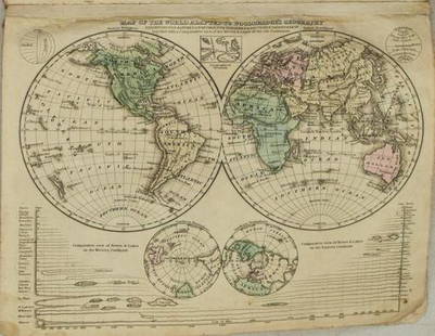
Sold20211831 Woodbridge World Map -- Map of the World AdaptedTitle: 1831 Woodbridge World Map -- Map of the World Adapted to Woodbridge's Geography Cartographer: W. Woodbridge Year / Place: 1831, Hartford Map Dimension (in.): 8.6 X 10.8 in. This is a very niceSee Sold Price
Sold20181843 William Woodbridge World Map1843 William C. Woodbridge Moral and Political Chart of the Inhabited World. Measures 12" x 17.5" (sheet size). G-Vg/Vg condition. Unframed, loose and not mounted or glued down. We ship all items in tSee Sold Price
Sold20191821 Chart of the World Map This is a mercator'sThis is a mercator's projection of North America by John Purdy, published Jan 1, 1821 by Richard Holmes Laurie, measures 40" wide by 26.5" tall.See Sold Price
Sold2018Antique Pair Of Maps Of America & The WorldAntique Pair Of Maps Of United States & World, these antique maps are both from W.C. Woodbridge, one map is a world map of the inhabited world, the other is a map of America, the prints have matting bSee Sold Price
Sold2017de la Tour: Antique Map of World; Twin Hemispheres 1777Title/Content of Map: 'Mappemonde' World twin hemispheres Date Printed: 1777 Image Size: Approx 18.5 x 16.5cm, 7.25 x 6.25 inches (Medium); Please note that this is a folding map. Type: Antique copperSee Sold Price
Sold2023German invasion of Belgium and France, May-June 1940. World War 2 1953 old mapTITLE/CONTENT OF MAP: 'The German assault in the west, May-June, 1940' DATE PRINTED: 1953 IMAGE SIZE: Approx 19.0 x 25.0cm, 7.5 x 10 inches (Medium); Please note that this is a folding map. TYPE: VintSee Sold Price
Sold2017de la Tour: Antique Map of the Ancient World, 1777Title/Content of Map: 'Le Monde connu des Anciens' Date Printed: 1777 Image Size: Approx 18.5 x 16.5cm, 7.25 x 6.25 inches (Medium); Please note that this is a folding map. Type: Antique copperplate mSee Sold Price
Sold2022German invasion of Belgium and France, May-June 1940. World War 2 1953 old mapTITLE/CONTENT OF MAP: 'The German assault in the west, May-June, 1940' DATE PRINTED: 1953 IMAGE SIZE: Approx 19.0 x 25.0cm, 7.5 x 10 inches (Medium); Please note that this is a folding map. TYPE: VintSee Sold Price
Sold2022WESTERN FRONT MAIN BATTLE LINES. Vintage map. WW1 First World War. Flanders 1920TITLE/CONTENT OF MAP: 'The main battle lines of the Western front' DATE PRINTED: 1920 IMAGE SIZE: Approx 15.0 x 23.0cm, 5.75 x 9 inches (Medium); Please note that this is a folding map. TYPE: VintageSee Sold Price
Sold2023Spread of civilisation from antiquity to 1940. World on Kite Projection 1947 mapTITLE/CONTENT OF MAP: 'The Home of Mankind' DATE PRINTED: 1947 IMAGE SIZE: Approx 34.5 x 46.0cm, 13.5 x 18 inches (Large); Please note that this is a folding map. TYPE: Vintage colour atlas map CONDITSee Sold Price
Sold2018FIRST WORLD WAR: The Western Desert. Egypt;1935 mapTITLE/CONTENT OF MAP: 'The Western Desert' DATE PRINTED: 1935 IMAGE SIZE: Approx 18.0 x 22.0cm, 7 x 8.75 inches (Medium); Please note that this is a folding map. TYPE: Vintage map CONDITION: Good; suiSee Sold Price
Sold2023Barton's Decorative Map of the WorldBarton's Decorative Map of the World, Tweed type fabric with wood clamp top and bottom, featuring Countries and Capitals of the World with Time Zone Clocks along top, 34 1/2" x 45", early to mid 20thSee Sold Price
Sold2017Woodbridge: Antique Map of North America & West IndiesWOODBRIDGE, W.C. . London: Whittaker, 1821. From "Modern Atlas". Approximately 8-1/2 x 10-1/2, in plastic sleeve. Right margin a little close trimmed (no loss of image), else fine. Depicts the North ASee Sold Price
Sold2023Two Maps, Africa by Eustache Herisson, 1809, World Hemispheres 1832 Reprint after A.H Brue, GermanDescription: An antique Africa map, in French and dated 1809 by Eustache Herisson, and a reprit of an early 19th century map of World Hemispheres by Adrien-Hubert Brue. Type: MapMaterials: PaperMarkinSee Sold Price
Sold2021Geographical Map of The WorldGeographical Map of The World with the tracks of the most Celebrated Navigators, for the elucidation of Lavoisne's Geneological, Historical, Chronological, and Geographical Atlas. By C. Gros. 1821 17See Sold Price
5 days LeftJasper521753 Prevost Map of Pacific Wind Currents -- Representation du Cours ordinaire des Vents de Traverse$85
May 14Akiba Galleries(2 Pc) Allain Manesson Mallet Description De L'Univers 2 Vol. German Translation$200(1 bid)
May 16Potter & Potter AuctionsLANGENECKERT. It’s A Dog’s World. 1968. St. Louis: Ralston ...$100
May 16Potter & Potter AuctionsTUNIS, Edward (1897 – 1973). From Chesapeake Bay / Land of ...$250
May 16Potter & Potter AuctionsBOUCHER, Lucien (1889 – 1971). Provence Breguet 763 / Air F...$300