Sold2020Cadastral map of Crestline, San Bernardino Co., Cal.Heading: (California - San Bernardino County) Author: Title: Valley of Enchantment Mutual Water Co. Place Published: Crestline, CA Publisher: Date Published: c.1930 Description:See Sold Price
Sold20211930s Map of San Bernardino County, California --Title: 1930s Map of San Bernardino County, California -- Principal Automobile Routes of San Bernardino County California Cartographer: Automobile Club of Southern California Year / Place: 1930s, Los ASee Sold Price
Sold2021Large map of San Mateo County Cal. 1913Heading: (California - San Mateo County) Author: Denny, Edward, & Co. Title: Denny's Pocket Map of San Mateo County, California. Compiled from latest official and private data Place Published: San FraSee Sold Price
Sold2020Road map of Southern California 1918Heading: (California) Author: Title: Automobile Road Map of Los Angeles, Orange, Riverside and San Bernardino Counties Place Published: Los Angeles Publisher:Security Trust & Savings Bank Date PSee Sold Price
Sold2018Auto road map of greater Los Angeles, 1916Heading: (California - Southern) Author: Parker, O.K. Title: Automobile Road Map of Los Angeles, Orange, Riverside and San Bernardino Counties Place Published: Los Angeles Publisher:Security Trust & SSee Sold Price
Sold2020Real estate for sale in Portola Valley, Cal.Heading: (California - San Mateo County) Author: Title: Map of Brookside Park near Stanford, San Mateo County, California Place Published: Palo Alto, CA Publisher:Aust Realty Co. Date Published:See Sold Price
Sold2022Color map of San Francisco water districts 1912Heading: -1912 Author: Elliott, G.A. Title: Distributing System for San Francisco, Cal. Spring Valley Water Co. Place Published: San Francisco Publisher:[Spring Valley Water Co. Date Published: <See Sold Price
Sold2022San Mateo Co., Cal., Tide Lands at auction 1871Heading: (California - San Mateo County) Author: Allardt, Geo. F., Surveyor Title: Sale Map No. 9. Salt Marsh and Tide Lands situate in the County of San Mateo, State of California. To be sold at publSee Sold Price
Sold2022Pamphlet on Cal. oil fields w/ color map 1865Heading: Author: Silliman, Benjamin Title: Professor Silliman's Report Upon The Oil Property Of The Pacific Coast Petroleum Company, Of New -York, Situated In San Luis Obispo County, California. To wSee Sold Price
Sold2021Rare map of lands beneath Lake Berryessa, Cal.Heading: (California - Napa County) Author: Title: Map of land along the Putah Creek, most of which is now under Lake Berryessa Place Published: No place Publisher: Date Published: Late 19tSee Sold Price
Sold2019Samuel Augustus Mitchell (1790-1868), " County Map ofSamuel Augustus Mitchell (1790-1868), " County Map of California with an inset of San Francisco and the Settlements of Great Salt Lake Country, Utah," 1867, hand colored, H.-15 1/8 in., W.-12 1/2 in.See Sold Price
Sold2020Rare illustrated history of San Bernardino County 1883Heading: (California - San Bernardino County) Author: Elliott, Wallace W., publisher Title: History of San Bernardino County, California, with Illustrations, Descriptive of Its Scenery, Farms, ResidenSee Sold Price
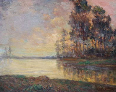
Sold2018Bertha Stringer Lee Painting Smilling Through,San MateoBertha Stringer Lee (1869-1937) oil painting entitled "Smilling Through San Mateo County, Cal". Signed lower right. Original exhibition label separate, not attached. Excellent condition. 20"h x 25"w.See Sold Price
Sold2022Map of the Ouray Gold District; 1890 [152841]Real, original map of the Ouray Gold District, Ouray County, Colorado. Surveyed and Compiled by Wheeler & Hurlburt, F.L. Biddlecom and W.A Sherman, Civil and Mining Engineers. Ouray Colorado. JanuarySee Sold Price
Sold2015Official map of the county of San Mateo, California,Official map of the county of San Mateo, California, showing the new boundary line and delineating the lines of cities, towns, private claims, ranchos, water works and rail roads Official Map of the CSee Sold Price
Sold2022Red Mining District Original Map; 1891 [152840]Real, original Map of the Red Mountain Mining District, Ouray County, Colorado. Scale of 1000 ft. to 1 inch. W.A. Sherman M.E. Ouray, Colo. 1891. Printed by Rand McNally & Co. Engravers, Chicago. HasSee Sold Price
Sold2022MS. map of Richmond District developmentsHeading: -1870 Author: Title: Manuscript map/plat of a portion of the Richmond District, San Francisco, ownership, homestead associations, etc. Place Published: [San Francisco] Publisher: Date PSee Sold Price
Sold2022Faust's Map of San Francisco 1904Heading: -1904 Author: Faust, H.W. Title: Faust's Map of City and County of San Francisco California Place Published: San Francisco Publisher:Published by H.W. Faust Date Published: 1904 <See Sold Price
Sold2022Faust's Map of San Francisco 1898Heading: -1898 Author: Faust, H.W. Title: Faust's Map of City and County of San Francisco California Place Published: San Francisco Publisher:Published by H.W. Faust Date Published: 1898 <See Sold Price
Sold2022Bancroft's large folding map of S.F. 1887Heading: -1887 Author: Title: Bancroft's Official Guide Map of City and County of San Francisco, Compiled from Official Maps in Surveyor's Office Place Published: San Francisco Publisher:The BancroftSee Sold Price
Sold2022Large ms. map from Mission to Castro SF c1864Heading: -1864 Author: Title: Map Shewing the Subdivision of the R.J. Tiffany and B.D. Dean Tract. San Francisco Cal. Scale 100 Feet to One Inch Place Published: San Francisco Publisher: Date PuSee Sold Price
Sold2021Bancroft's Map of California, Nevada, 1873Heading: Author: Bancroft, Albert Little Title: Bancroft's Map of California, Nevada, Utah and Arizona, Published by A. L. Bancroft & Compy. Booksellers & Stationers San Francisco Cal. 1873 Place PubSee Sold Price
Sold2022Map of San Francisco Tidelands for sale, 1869Heading: -1869 Author: Allardt, Geo. F., Surveyor Title: Map No. 3 of Salt Marsh and Tide Lands Situate in the City & County of San Francisco. To be sold at Public Auction, by order of the Boards of TSee Sold Price
Sold2023Bancroft's Map of California and Nevada, Dated 1868Framed Bancroft's Map of California and Nevada, Dated 1868. 'BANCROFT'S MAP OF CALIFORNIA AND NEVADA Published by H.H. Bancroft & Co. Booksellers & Stationers SAN FRANCISCO, CAL. 1868', lower left corSee Sold Price
5 days LeftJasper52New Map of That Portion of North America Exhibiting the United States and Territories...Mexico...$360
May 18Rich Penn AuctionsGunpowder Calendar from The California Powder Works San Francisco, Cal., c.1902 w/full calendar pad,$150(2 bids)
May 11Crescent City Auction GalleryWilliam H. Williams (1817-1886), New Orleans "Map of the Sixth District and Carrollton," 1871, H.-$650


![Map of the Ouray Gold District; 1890 [152841]: Real, original map of the Ouray Gold District, Ouray County, Colorado. Surveyed and Compiled by Wheeler & Hurlburt, F.L. Biddlecom and W.A Sherman, Civil and Mining Engineers. Ouray Colorado. January](https://p1.liveauctioneers.com/2699/258191/134290994_1_x.jpg?height=310&quality=70&version=1660351799)

![Red Mining District Original Map; 1891 [152840]: Real, original Map of the Red Mountain Mining District, Ouray County, Colorado. Scale of 1000 ft. to 1 inch. W.A. Sherman M.E. Ouray, Colo. 1891. Printed by Rand McNally & Co. Engravers, Chicago. Has](https://p1.liveauctioneers.com/2699/258191/134290995_1_x.jpg?height=310&quality=70&version=1660351799)
![MS. map of Richmond District developments: Heading: -1870 Author: Title: Manuscript map/plat of a portion of the Richmond District, San Francisco, ownership, homestead associations, etc. Place Published: [San Francisco] Publisher: Date P](https://p1.liveauctioneers.com/642/242590/125758412_1_x.jpg?height=310&quality=70&version=1648613138)


![[TEXAS] 1877 Cattle Rustling Court Warrant (1 of 2)](https://p1.liveauctioneers.com/7226/322253/173251514_1_x.jpg?height=282&quality=70&version=1710004847)


