Sold2018Rare 1921 auto road atlas. 11.7 x 15Reserve Reduced! This rare and unusual early auto road atlas was published during the time the National Highway System was being developed. It includes individual “auto-trails” maps for each stateSee Sold Price
Sold2017America, Rare Early Map of the Americas"America", Rare Early Map of the Americas by Jodocus Hondius (Flemish/Dutch, 1563-1612) for a French edition of Mercator's Atlas, North and South America, hand-colored copper engraved map, published ASee Sold Price
Sold2020Antigua labeled Antego. RARE early map.Title: Antigua labeled Antego. RARE early map. Description: c1732/1736 from the Atlas Minor by Herman Moll, London. VERY IMPORTANT early map of the island. Showing all the settlements and plantations.See Sold Price
Sold2023BETTER GRADE 1858 FLYING EAGLE CENT, RARE EARLY US COIN, ONLY IN CIRCULATION FOR 2 YEARSBETTER GRADE 1858 FLYING EAGLE CENT, RARE EARLY US COIN, ONLY IN CIRCULATION FOR 2 YEARSSee Sold Price
Sold2023Rare Early 1900's Map of Porto Rico ( Puerto Rico )Rare early 1900's ( copyright of 1908 ) Map of Porto Rico, including Port San Juan, Islands West of Porto Rico, Mayaguez Bay & Port Ponce from Rand, McNally & Co. 8 3/4" X 12". ** fold through the cenSee Sold Price
Sold2023Japanese Map of Ancient China, Apparently 12th - 16th CenturyAn exceptional and rare early Japanese map, hand painted, depicting China from the Zhou or Qin Dynasty. The map depicts the Chinese Nine Zhou, or provinces, utilizing nomenclature used in Japan circaSee Sold Price
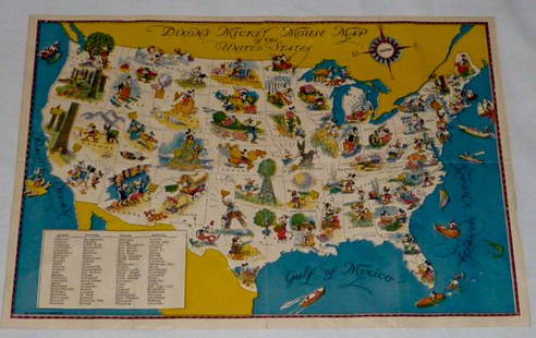
Sold2022Walt Disney Dixon's Mickey Mouse Map of United StatesEarly Disneyana collectible map. Copyright Walt Disney Enterprises 1935. Rare early pictorial map of the United States , richly illustrated with Disney character vignettes in each of the 48 states, MiSee Sold Price
Sold2023The New World Wide Postage Stamp Album - with Rare ContentsThe New World Wide Postage Stamp Album - with Rare Contents Rare stamps! Early U.S. stamps dated from 1869 (24 dated 1912 and prior). U.S. stamps including plate blocks, air mail issues, and more. ForSee Sold Price
Sold2021Pender County North Carolina mapPender County North Carolina state highway commission map, US Department of commerce Bureau of public roads state wide highway planning survey from January 1, 1961, size is 19“ x 31“ in very goodSee Sold Price
Sold2021New Hanover county North Carolina mapNew Hanover county North Carolina state highway commission map, US Department of commerce Bureau of public roads statewide highway planning survey from January 1, 1961, size, 19“ x 32“ in very gooSee Sold Price
Sold2022Britains Foreign Nations Assortment.UNBOXED French Foreign Legion, Chinese Infantry, Belgian, Togoland Warrior, rare and early U.S. Marine bandsman. 5 pieces, condition excellent. No box. All others are circa 1950s.See Sold Price
Sold2021Early English map of U.S. 1783Heading: Author: Kitchin, Thomas Title: Map of the United States in North America: with the British, French and Spanish Dominions adjoining, according to the Treaty of 1783. Place Published: London PSee Sold Price
Sold2021Early U.S. map shows Texas, Upper Calif. – 1839Title: Early U.S. map shows Texas, Upper Calif. – 1839 Description: Vintage and interesting geography map showing Texas and Upper California at a time when they made up the entire southwestern UniteSee Sold Price
Sold2023Rare 19thc Census Map, U.S. Agricultural ProductionExtremely rare, original 1876 atlas map of the United States Agriculture Production - five agricultural maps (in inset form) of the production of wheat, hay, corn, cotton and tobacco. Each map distingSee Sold Price
Sold2017Antique Important Map of Texas, 1843Title/Content of Map: Texas. Rare and important early Map. Date Printed: 1843 Cartographer: based on the work of H.C. Tanner Material/Medium: Paper Size: 17" x 14" Hand colored engraved Map. From theSee Sold Price
Sold2023Japanese Map of Feudal Castles Apparently Circa 1550A rare and early Japanese map, depicting the feudal castles of Owari province, including Kiyosu Castle, occupied by Shiba Yoshimune as governor of Owari and head of the Shiba Clan. Apparently of the pSee Sold Price
Sold20181839 Mitchell Map of the United StatesTitle/Content of Map: 1839 Mitchell Map of the United States -- No. 5 Map of the United States Date Printed: 1839, Philadelphia Cartographer: S Mitchell Size: 10.2 x 16.7 in. This early US map has terSee Sold Price
Sold2023Rare Antique US Early 1800's 2 Navy Naval Engraved Daggers Dirks w/ ScabbardsRare Antique US Early 1800's 2 Navy Naval Engraved Daggers Dirks w/ ScabbardsOriginal Very Rare Antique US Early 1800's Navy Engraved Small Dagger Dirks with Scabbard. Modeled after Royal British navySee Sold Price
Sold2016EARLY BOXED U.S. MAP PUZZLEby Mcloughlin Bros., N.Y. with fine chromolithographed lidded box with Miss Columbia and Indian child, dated 1887, with complete 37 piece chromolithographed puzzle map of the United States, box is 8 1See Sold Price
Sold20211923 US Rail Road MapTitle: 1923 US Rail Road Map Author: McNally Materials: Ink on Paper Dimensions: 28"X21" Description: United States Rail Road Map dated 1923. Published by McNally & Co in Chicago. Shows detailed railSee Sold Price
Sold20211819 RARE Jedidiah Morse MAPS American Geography US1819 RARE Jedidiah Morse MAPS American Geography US Constitution Indians Europe Jedidiah Morse was an important and prominent geographer known for his American textbooks, books that earned him the namSee Sold Price
Sold20211805 RARE MAPS Jedidiah Morse American Geography US1805 RARE MAPS Jedidiah Morse American Geography US Constitution Indians Europe Jedidiah Morse was an important and prominent geographer known for his American textbooks, books that earned him the namSee Sold Price
Sold2023Rare map of Upper Territories by Mathew Carey, 1814Early and rare map of the old Northwest Territory. In this map the area of Michigan has yet to be understood. The extents of Saginaw Bay and Green Bay are also more or less guessed at. The map reflectSee Sold Price
Sold2023RARE WWII OSS Theater-Made Jump OvalsMade in N. Africa. Sewn to US OD. Exceptionally rare, early OSS InsigniaSee Sold Price
May 16Potter & Potter AuctionsMap to Acquaint You with the Great Mission Bay Project. 194...$125(1 bid)
4 days LeftJasper521890 c. Clemens Wooden Puzzle Map of the US -- Clemens' Silent Teacher Dissected Map of the United$240
22 hrs LeftTrillium Antique Prints & Rare BooksPtolemy & Magini, pub. 1620 - Map of the World with Six Windheads$130(4 bids)
22 hrs LeftTrillium Antique Prints & Rare BooksPtolemy & Magini, pub. 1620 - Double Hemisphere Map of the World$400(5 bids)
22 hrs LeftTrillium Antique Prints & Rare BooksPtolemy & Magini, pub. 1620 - Map of Northeast Asia and Northwest America including Japan$50(1 bid)
22 hrs LeftTrillium Antique Prints & Rare BooksPtolemy & Magini, pub. 1620 - Map of the British Isles (England, Scotland, Ireland) / Verso: Map of$50(1 bid)
22 hrs LeftTrillium Antique Prints & Rare BooksPtolemy & Magini, pub. 1620 - Map of Asia (Includes Japan and part of Ausralia as Terra Incognita)$50
22 hrs LeftTrillium Antique Prints & Rare BooksPtolemy & Magini, pub. 1620 - Map of France / Verso: Map of Germany$50
May 04Trillium Antique Prints & Rare BooksPtolemy & Magini, pub. 1620 - Map of the Ancient World with Africa, Europe, Asia$50
May 04Trillium Antique Prints & Rare BooksPtolemy & Magini, pub. 1620 - Map of Taprobana, Island in Sumatra$50
1112 Lots AwayMynt AuctionsCrescent by Schulz & Fischer Sterling Silver Dinner Spoon / Serving Spoon 8 1/2"$10