Sold2016C Dohet (Claude dates unknown) Sabena Pictorial MapC Dohet (Claude dates unknown) Sabena Pictorial Map centring on Africa, original small poster printed by Linsmo c. 1960 - 34.5 x 22 cmSee Sold Price
Sold2022Sabena Belgian World Airlines. Brussels: Marci, ca. 1966. R...Sabena Belgian World Airlines. Brussels: Marci, ca. 1966. Route map poster of Europe, Africa, and the Middle East labeled with Sabena’s routes as well as seasonal routes and connecting carriers.See Sold Price
Sold2018Belgian Congo and South Africa. Sabena BelgianDohet, Claude. Belgian Congo and South Africa. Sabena Belgian Airlines. Brussels: Litho Linsmo, ca. 1960. Attractive color lithograph depicting a colorful African mask entwined with a bamboo stick. LiSee Sold Price
Sold2018Vintage Hawaiian Airline Route Map of Hawaii, 1953Title/Content of Map: 1953 Hawaiian Airline Route Map of Hawaii -- Hawaiian Airline Map of the State of Hawaii Date Printed: 1953 Cartographer: Hawaiian Airline Size: 9.2 x 21 in This is a very nice mSee Sold Price
Sold20231950s Hawaiian Airline Route Map of Hawaii -- Hawaiian Airline Map of the State of HawaiiTitle: 1950s Hawaiian Airline Route Map of Hawaii -- Hawaiian Airline Map of the State of Hawaii Cartographer: Hawaiian Airline Year / Place: mid 1950s Map Dimension (in.): 9.2 x 24 in This is a verySee Sold Price
Sold20191957 Quantas Airline Route Map -- Quantas AirlinesReserve Reduced! Title/Content of Map: 1957 Quantas Airline Route Map -- Quantas Airlines Route Map Date: 1957 Cartographer: Quantas Airlines Size: 11.2 x 8.3 in. This is a rather interesting advertisSee Sold Price
Sold2023Group of 18 Pan Am Airline Route Maps and MenusIncludes Rainbow Service menus, Some large tears in maps, Largest map measures 9 x 12in folded.See Sold Price
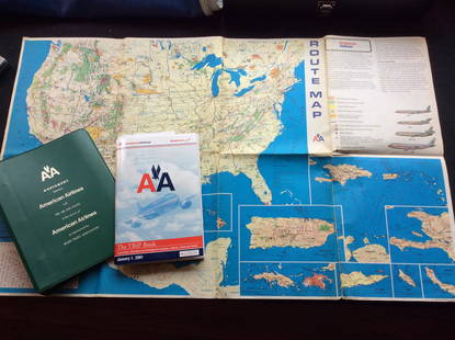
Sold2023Vintage American Airlines Route Map, American Airline Trip Book and BinderVintage American Airlines Route Map, American Airline Trip Book and BinderSee Sold Price
Sold2021Color pictorial bird's-eye airline route maps 1929Heading: (Aviation - pictorial route maps) Author: Title: Western Air Express: Travel by Air, Speed - Comfort - Dependability Place Published: [California?] Publisher:Western Air Express Date PuSee Sold Price
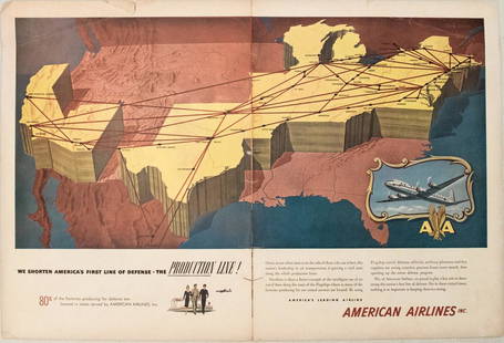
Sold20191949 American Airlines Route Map AdTitle/Content of Map: 1949 American Airlines Route Map Ad Date: 1949Cartographer: American Airlines Size: 13.6 X 21 in. when joined This is an attractive ad highlightingAmerican Airlines routes - servSee Sold Price
Sold20231950s American Airlines Route Map -- American Airlines Route MapTitle: 1950s American Airlines Route Map -- American Airlines Route Map Cartographer: American Airlines Year / Place: 1950s Map Dimension (in.): 12.5 X 19.2 in. joined This nice, large pictorial routeSee Sold Price
Sold2023PAN AMERICAN AIRLINES ROUTE MAP. "Fastest way between… USA & Latin America" 1935Title: PAN AMERICAN AIRLINES ROUTE MAP. "Fastest way between… USA & Latin America" 1935 Description: Consult this map for fastest way between all points in the United States and Latin America' bSee Sold Price
Sold2018United Airlines Route Map A Gay Geography of Main LineUnited Air Lines. A Gay Geography of the Main Line Airway. The Main Line Mid-Continental Airway published in 1939 route map. See Sold Price
Sold2018American Airlines Route Map World's Fair Line 1939American Airlines Route Map World's Fair Line 1939See Sold Price
Sold2018North Atlantic Airlines Route Map Information Booklet CNorth Atlantic Airlines Route Map Information Booklet Circa 1950sSee Sold Price
Sold2020Air France. Flying Holidays this Year! Circa 1935.Air France. Flying Holidays this Year! Circa 1935. Offset lithograph travel poster with the airline’s route map printed within the outline of a propeller plane, covering major cities of Europe aSee Sold Price
Sold20202 Rare European Route Maps ~ Farmanhere two great airline route maps, also includes postcards, a very rare lot!See Sold Price
Sold20221960 Hawaiian Airlines Pictorial Route Map -- The Hawaiian IslandsTitle: 1960 Hawaiian Airlines Pictorial Route Map -- The Hawaiian Islands Cartographer: Hawaiian Airlines Year / Place: 1960 Map Dimension (in.): 8.9 X 20.2 in This is an attractive pictorial airlineSee Sold Price
Sold20221940s American Airlines US Route Map -- American Airlines System MapTitle: 1940s American Airlines US Route Map -- American Airlines System Map Cartographer: American Airlines (General Drafting Co.) Year / Place: 1940s c. Map Dimension (in.): 24 X 32 in. Ths is an attSee Sold Price
Sold2018SAS Scandinavian Airlines Europe Route Map 1958SAS Scandinavian Airlines Europe Route Map 1958See Sold Price
Sold2022Vintage Air France Airline Travel Routes World MapVintage Air France Airline Travel Routes World Map, by Lucien Boucher (French, 1889-1971) color offset, C.1948. Framed. Size: 19.5'' x 33.75'', 50 x 86 cm (sight); 24.5'' x 39'', 62 x 99 cm (frame).See Sold Price
Sold20181957 Hawaiian Airlines Convair 340 Route Map --Title/Content of Map: 1957 Hawaiian Airlines Convair 340 Route Map -- Hawaiian Airlines Route Map Date: 1957 Cartographer: Hawaiian Airlines Size: 8.5 x 11.2 in. This is an attractive advertising showSee Sold Price
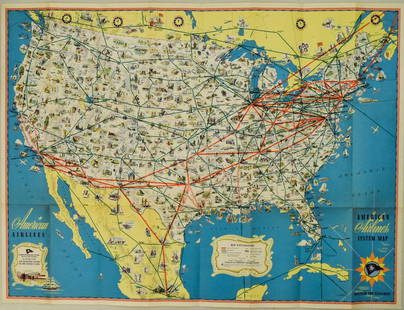
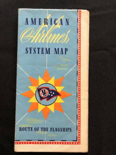
Sold2018American Airlines System Map Route Of The Flagships 194American Airlines System Map Route Of The Flagships 1946See Sold Price
Sold20171950 Map of PanAm Airline Caribbean Routes1950 Map of PanAm Airline Caribbean Routes -- Pan American Flight Map New York and Caribbean. PanAm, 1950 ca., A nice folding map of Pan American Airline routes to Caribbean from New York City & MiamiSee Sold Price
4 days LeftJasper521970s Hawaiian Airlines Pictorial Route Map -- Hawaiian Airlines Map of the Hawaiian Islans$35
5 days LeftRail & Road Auctions1951 Chicago, Milwaukee, St. Paul & Pacific Railroad Wall Map - Route of the Hiawathas$50
May 16Potter & Potter AuctionsSabena Belgian World Airlines / Europe’s Most Helpful Airli...$100
6 days LeftRail & Road AuctionsThree American Aviation Publications - 1953 and 1956 Official Airline Guides and 1948 Air Traffic$30
4 days LeftJasper521960 Alaska Cruise Lines Pictorial Map of Alaska -- State of Alaska Visitor's Map$30
4 days LeftJasper521943 Denver & Rio Grande Western Railroad Map in Rocky Mountain Views Brouchure -- Rocky Mountain$40
6 days LeftRail & Road AuctionsPair of American Aviation Official Airline Guides - October 1957 and March 1965$20
6 days LeftRail & Road AuctionsMixed Group of Twelve Airline Timetables - Frontier, Eastern, Southern, Texas International, and$20
5 days LeftJasper52Amér Sep Porto Rico #69 Puerto Rico & Virgin Islands VANDERMAELEN 1827 old map$130


![Color pictorial bird's-eye airline route maps 1929: Heading: (Aviation - pictorial route maps) Author: Title: Western Air Express: Travel by Air, Speed - Comfort - Dependability Place Published: [California?] Publisher:Western Air Express Date Pu](https://p1.liveauctioneers.com/642/204898/103985846_1_x.jpg?height=310&quality=70&version=1621652446)