Sold20231950s Hawaiian Airline Route Map of Hawaii -- Hawaiian Airline Map of the State of HawaiiTitle: 1950s Hawaiian Airline Route Map of Hawaii -- Hawaiian Airline Map of the State of Hawaii Cartographer: Hawaiian Airline Year / Place: mid 1950s Map Dimension (in.): 9.2 x 24 in This is a verySee Sold Price
Sold2018Vintage Hawaiian Airline Route Map of Hawaii, 1953Title/Content of Map: 1953 Hawaiian Airline Route Map of Hawaii -- Hawaiian Airline Map of the State of Hawaii Date Printed: 1953 Cartographer: Hawaiian Airline Size: 9.2 x 21 in This is a very nice mSee Sold Price
Sold20181978 Hawaiian Airline Pictorial Map of Hawaii -- HawaiiTitle/Content of Map: 1978 Hawaiian Airline Pictorial Map of Hawaii -- Hawaii Date Printed: 1978 Cartographer: Hawaiian Airline Size: 12 x 18 in. A very nice pictorial map of Hawaii with air routes ofSee Sold Price
Sold2017VINTAGE 1960's HAWAIIAN AIRLINES MAP OF HAWAII, GOODVINTAGE 1960's HAWAIIAN AIRLINES MAP OF HAWAII, GOOD VINTAGE CONDITION, FRAMED SIZE 16.75" X 12.5", SKU7540See Sold Price
Sold2018Hawaiian Airlines "See All Hawaii" Map and BrochureHawaiian Airlines "See All Hawaii" map and brochure.ÂSee Sold Price
Sold20181957 Hawaiian Airlines Convair 340 Route Map --Title/Content of Map: 1957 Hawaiian Airlines Convair 340 Route Map -- Hawaiian Airlines Route Map Date: 1957 Cartographer: Hawaiian Airlines Size: 8.5 x 11.2 in. This is an attractive advertising showSee Sold Price
Sold20221960 Hawaiian Airlines Pictorial Route Map -- The Hawaiian IslandsTitle: 1960 Hawaiian Airlines Pictorial Route Map -- The Hawaiian Islands Cartographer: Hawaiian Airlines Year / Place: 1960 Map Dimension (in.): 8.9 X 20.2 in This is an attractive pictorial airlineSee Sold Price
Sold2019Feher, Joseph (1909-1987). Hawaii. United Airlines.Feher, Joseph (1909-1987). Hawaii. United Airlines. Circa 1950s. A travel poster of a woman wearing a lei of flowers doing the hula dance is standing on an island with fish and aboriginal Hawaiians deSee Sold Price
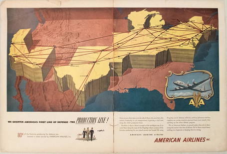
Sold20231950s American Airlines Route Map -- American Airlines Route MapTitle: 1950s American Airlines Route Map -- American Airlines Route Map Cartographer: American Airlines Year / Place: 1950s Map Dimension (in.): 12.5 X 19.2 in. joined This nice, large pictorial routeSee Sold Price
Sold2018Hawaii Hawaiian IslandsTitle/Content of Map: Hawaii Hawaiian Islands Date: 1901 Cartographer: DONN, JOHN M./W.D. ALEXANDER/WALTER E. WALL/C.J. LYONS/J.S. EMERSON et al. Size: 34.4 X 37.7 "Primary triangulation by W.D. AlexaSee Sold Price
Sold2024Antique Hawaiian Islands Government Survey Maps (Set of 6)Lot of 6 antique Hawaiian governmental survey maps (Hawaii, Lanai, Kaho'olawe, Maui, Moloka'I, Oahu, and the full island chain), signed by W.A.Wall. Framed w/ glass and single matted. (14"H 11.5"W 1"DSee Sold Price
Sold2018North Atlantic Airlines Route Map Information Booklet CNorth Atlantic Airlines Route Map Information Booklet Circa 1950sSee Sold Price
Sold2023PAN AMERICAN AIRLINES ROUTE MAP. "Fastest way between… USA & Latin America" 1935Title: PAN AMERICAN AIRLINES ROUTE MAP. "Fastest way between… USA & Latin America" 1935 Description: Consult this map for fastest way between all points in the United States and Latin America' bSee Sold Price
Sold2018Map of Hawaii. United Airlines. Our Little Corner ofMap of Hawaii. United Airlines. Our Little Corner of the World. Archar, 1979. An overview of the main island, illustration by Kim Forrest. Linen backed. 24 x 33". Short repaired tears and minor lossesSee Sold Price
Sold20211865 Hawaiian Islands Pacific Islands Kamehameha1865 Hawaiian Islands Pacific Islands Kamehameha Portraits EARLY HAWAII MAP Rufus Anderson’s “The Hawaiian Islands” is a 19th-century account of the Pacific islands covering the origin of the isSee Sold Price
Sold2018Map of Kauai, Hawaii. United Airlines. Our LittleMap of Kauai, Hawaii. United Airlines. Our Little Corner of the World. Archar, 1980. An overview of the islands, illustration by James Olsen. Linen backed. 24 x 33". A.See Sold Price
Sold2023Northwest Orient Airlines / Hawaii. Circa 1960s. A smiling ...Northwest Orient Airlines / Hawaii. Circa 1960s. A smiling Hawaiian woman gestures toward the viewer, holding a lei. 29 ¼ x 20 ½”. Linen backed. Few spots of restoration in lower corneSee Sold Price
Sold2022[HAWAII]. [TRAVEL EPHEMERA]. A group of ephemera from hotel...[HAWAII]. [TRAVEL EPHEMERA]. A group of ephemera from hotels, cruise lines, and airlines, all which service Hawaii and the Pacific. Included: [HAWAIIAN AIRLINES]. Black and white photo of a passengerSee Sold Price
Sold2021[HAWAII] Dole Pictorial Map of the Hawaiian Islands.[HAWAII] Dole Pictorial Map of the Hawaiian Islands. 1937. Offset lithograph. Scarce pre-war pictorial map of the islands, filled with vignettes of the natural and man-made landmarks, modes of transpoSee Sold Price
Sold20171881 Hawaii Government Map of Oahu -- Oahu HawaiianTitle/Content of Map: 1881 Hawaii Government Map of Oahu -- Oahu Hawaiian Islands Date Printed: 1,881 Cartographer: Hawaii Government Surveys Size: 26.5 x 34.9 in. This large, detailed map of Oahu froSee Sold Price
Sold20221960's United Airlines Hawaii Poster Hula Girl (HoT)#10Item: Up for sale from a well known estate in Honolulu original 1960s United Airlines Hawaii Travel Tourism poster with a Hawaiian Hula Girl motif. The condition is described below for more details plSee Sold Price
Sold2022United Airlines / Hawaii. Circa 1960s. A smiling young Hawa...United Airlines / Hawaii. Circa 1960s. A smiling young Hawaiian woman poses with a lei and a bowl of fruit set among indigenous plants. 40 x 25”. A.See Sold Price
Sold2018Hawaii. Aloha Airlines.Hawaii. Aloha Airlines. 1980s. Colorful map of the islands of Hawaii with illustrations of sea life, an airplane, flora, and a woman in bikini. Linen backed. 23 x 35". A.See Sold Price
Sold2019Map & view of Hawaii, c.1785Heading: (Hawaii) Author: Title: French map of the Hawaiian Islands & view of Karakakooa, framed together. Place Published: Paris Publisher: Date Published: c.1785 Description:See Sold Price
5 days LeftJasper521970s Hawaiian Airlines Pictorial Route Map -- Hawaiian Airlines Map of the Hawaiian Islans$35
6 days LeftJasper52HAWAII HISPANIOLA. Hawaiian Isles; Haiti San Domingo Dominican Republic 1898 map$20
5 days LeftJasper521960 Alaska Cruise Lines Pictorial Map of Alaska -- State of Alaska Visitor's Map$30
May 10Rail & Road AuctionsThree American Aviation Publications - 1953 and 1956 Official Airline Guides and 1948 Air Traffic$30
5 days LeftBidhaus1985 East-West Center 20th Anniversary Hawaiian Art Poster Framed Yevonne Cheung$10
May 12Hoch LTD.John Severson (American, 1933 - 2017) Signed Surf Art Oil on Canvas Painting, Hawaiian Mountain View$50


![[HAWAII]. [TRAVEL EPHEMERA]. A group of ephemera from hotel...: [HAWAII]. [TRAVEL EPHEMERA]. A group of ephemera from hotels, cruise lines, and airlines, all which service Hawaii and the Pacific. Included: [HAWAIIAN AIRLINES]. Black and white photo of a passenger](https://p1.liveauctioneers.com/928/265343/138522942_1_x.jpg?height=310&quality=70&version=1666130009)
![[HAWAII] Dole Pictorial Map of the Hawaiian Islands.: [HAWAII] Dole Pictorial Map of the Hawaiian Islands. 1937. Offset lithograph. Scarce pre-war pictorial map of the islands, filled with vignettes of the natural and man-made landmarks, modes of transpo](https://p1.liveauctioneers.com/928/200564/101543113_1_x.jpg?height=310&quality=70&version=1618323144)


