Sold2021San Diego with pictorial recreation map 1935Heading: (California - San Diego) Author: Title: Map of San Diego California City and County - with two maps, one a pictorial bird's-eye map Place Published: [San Diego] Publisher:Lowell E. Jones <See Sold Price
Sold2022BISHOP, Roy. Seattle. Bellevue: Bayside Publishing, 1976. C...BISHOP, Roy. Seattle. Bellevue: Bayside Publishing, 1976. Cartoonish pictorial bird’s-eye view map poster of Seattle. While the artist labels the city’s roads, bridges, and waterways, andSee Sold Price
Sold2023Bethlehem pictorial bird's eye view city plan. Israel. #104. BOLLMANN 1970 mapTitle: Bethlehem pictorial bird's eye view city plan. Israel. #104. BOLLMANN 1970 map Description: Bethlehem' by Hermann Bollmann (1970). Vintage axonometric "bird's eye view" city tourist plan, 54.5See Sold Price
Sold2023Chicago. “City Character Print.” 1981. Toronto: Archar Inc....Chicago. “City Character Print.” 1981. Toronto: Archar Inc. Pictorial map with a bird’s-eye view of the city, initialed in plate to lower right, “R.V.N.” 13 5/8 x 18 3/8&See Sold Price
Sold2023ASSORTED EUROPEAN / AFRICAN PICTORIAL MAPS, LOT OF TWOASSORTED EUROPEAN / AFRICAN PICTORIAL MAPS, LOT OF TWO, engraving on paper, comprising a bird's-eye view of the siege of the town Oost Ende (Ostend), a Flemish town, during The Eighty Years' WSee Sold Price
Sold2017Antique Birds Eye Map of the Mississippi Basin, 1866Title/Content of Map: Antique Birds Eye View of the Mississippi Basin Date Printed: 1866 Cartographer: Anonymous Size (inches): 9 x 14 Condition: Good. Slightly age toned as typical for paper of the eSee Sold Price
Sold2017J. J. Stoner, Birds-eye map of Helena, MontanaJ. J. Stoner, Birds-eye map of Helena, Montana, J.J. Stoner (American, 19th c.), "Bird's Eye View of Helena, 1883", illustrated and with index of points of interest, hand-colored engraving, publishedSee Sold Price
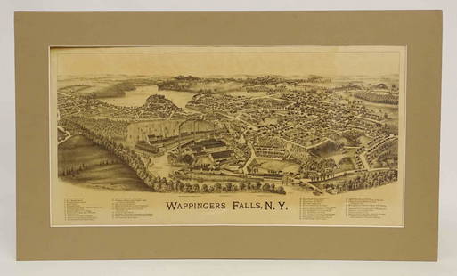
Sold2022Wappingers Falls New York Large ViewWappingers Falls, N.Y. Large Panorama Bird's-eye Map. L.R. Burleigh, Troy, New York, c. 1889. Antique print. 15" x 29".See Sold Price
Sold2015OLD MAP OF PARISA BIRD'S EYE MAP OF PARIS CITY FRINGED WITH THUMBNAILS OF THE TOP TOURIST SPOTS 28X38"See Sold Price
Sold2021(2) ANTIQUE GERMAN ETCHINGSIncluding a bird's eye map and aerial and profile views of German castle. Dimensions: (Larger frame) H 19" x W 23.5", (Sight) H 9.25" x W 13.5" Condition: Few signs of wear. One spot of discolorationSee Sold Price
Sold2021EDDY, Gerald. Lake Tahoe / California-Nevada. Reno:EDDY, Gerald. Lake Tahoe / California-Nevada. Reno: Silver State Press, 1965. Offset lithograph birds-eye map of the area surrounding Lake Tahoe, looking east, showing Reno, Sparks, and Carson City, mSee Sold Price
Sold2023Bird's Eye View Map of Middletown, ConnecticutBird's Eye View Map of Middletown, Connecticut, originally published in 1877 by O.H. Bailey & Company, for the Library of Congress, Washington, D.C. revised in 1880 with additional rare border, includSee Sold Price
Sold2024Large Original 1958 Bird's Eye View Map of ParisLarge Original 1958 Bird's Eye View Map of ParisLarge Original 1958 Bird's Eye View Map of Paris in vibrant green, red, and black tones, states "Printed in France - Published By and For the FrencSee Sold Price
Sold20221890 Kessler Brewery/American Publishing Birds Eye View Map of Helena Montana -- Perspective Map ofTitle: 1890 Kessler Brewery/American Publishing Birds Eye View Map of Helena Montana -- Perspective Map of the City of Helena, Mont. Capital of State, County Seat of Lewis & Clarke Co. 1890 CartographSee Sold Price
Sold2017Currier & Ives: San Francisco Birds Eye View Map, 1878Map: The City of San Francisco Birds Eye View Looking from the Bay South-West Cartographer: Currier & Ives Date: 1878 Size: 11.4 x 17.75 inches This is a rare view of San Francisco of the late 1800s lSee Sold Price
Sold2023Bird's-Eye View Map of the City of Chicago (1874)Bird's-eye view map of the city of Chicago, Illinois sketched and drawn by Parsons & Atwater, published by Currier & Ives, dated 1874; unframed. Provenance: Phyllis Lucas Gallery, NYC. [Sheet: 23 1/4"See Sold Price
Sold2022Disneyland Souvenir Map. 1972. Walt Disney Productions, 197...Disneyland Souvenir Map. 1972. Walt Disney Productions, 1972. Bird’s-eye view map of the park, with an inset vignette advertising Disneyland’s Bear Country attraction in the lower left. 30See Sold Price
Sold2024Theodore R. David (American 1840-1894) For Harper's Weekly 1872Theodore R. David (American 1840-1894) For Harper's Weekly 1872 "Birds Eye View Map of Philadelphia" colored and engraved map, published June 15, 1872 21" x 31" Condition: having yellowing to paper anSee Sold Price
Sold20201587 Birds Eye View of Ghent -- [Untitled] GentTitle/Content of Map: 1587 Birds Eye View of Ghent -- [Untitled] Gent Date: 1587 c. Cartographer: Anonymous Size: 8.3 x 10.6 in. A very nice and detailed birds' eye view map of the market city of GhenSee Sold Price
Sold2022Lot 2, Vintage Scratch Map & Boston Block Print1 vintage scratch map of the world. Approximately 23 x 32 inches. 1 The town of Boston in New England by John Bonner, 1722. Depicting a birds eye view map of the city of Boston in 1722. ApproximatelySee Sold Price
Sold2024Rare Civil War map: Bird's Eye View Seat of War, Prang, 1862BIRD'S EYE VIEW OF THE SEAT OF WAR, 1862, Civil War lithograph map published by Louis Prang & Co., Boston. Depicts key sites of the conflict including Washington, Baltimore, Harper's Ferry, Richmond,See Sold Price
Sold2022FRAMED VINTAGE 20'S TRAVEL MAP BIRD'S EYE VIEW OF BOSTON HARBOR 15 3/4" X 20" W/ COVER 7" X 7 1/2"FRAMED VINTAGE 20'S TRAVEL MAP BIRD'S EYE VIEW OF BOSTON HARBOR 15 3/4" X 20" W/ COVER 7" X 7 1/2"See Sold Price
Sold2018Map: Bird's Eye View of Port of Kure, Japan"The Bird's Eye View of Port of Kure". Map. Dimensions: 22" H x 42" W; See Sold Price
Sold2016c 1877 MAP BIRDS EYE VIEW OF BOSTON LITHOFramed Tinted Lithograph delineated by John Bachmann, published by L. Prang & Co., Boston, 1877. In frame measures 22 50x18x1" Weight is 5 pds. PROVENANCE: A Private Charleston SC Estate.See Sold Price
5 days LeftPotter & Potter AuctionsPOLAND, Edwin Christian (1903 – 1991). The Evergreen Playgr...$200
5 days LeftPotter & Potter Auctions[NEW YORK CITY – PICTORIAL MAPS]. Group of 3 pictorial maps...$200(1 bid)
5 days LeftPotter & Potter AuctionsBOLLMANN, Hermann (1911 – 1971). Map of New York City. 1962.$100
5 days LeftPotter & Potter AuctionsLISTER, James Wren (1897 – 1952). Avalon Town / Santa Catal...$100(1 bid)
3 days LeftJasper52Bellin Map of St. Salvador, Brazil -- Plan de la ville de St. Salvador [with] Vue de la Ville de St.$55
Jun 07Freeman's | Hindman[MORMONS]. MILLROY & HAYES (fl. 1899). Route of the Mormon Pioneers from Nauvoo to Great Salt Lake,$300
3 days LeftJasper521614 Munster View of Utrecht Netherlands -- Von der Bischofflichen Statt Utrecht$70
5 days LeftPotter & Potter AuctionsPictorial Map of Hollywood and Vicinity / Hollywood Film Ca...$125(1 bid)
5 days LeftPotter & Potter AuctionsHANDY, R.D. (1879 – 1959). Paul Bunyan’s Pictorial Map of t...$200(1 bid)
5 days LeftPotter & Potter AuctionsWalt Disney World EPCOT Center. 1982. Color pictorial map o...$125
5 days LeftPotter & Potter AuctionsCrosby Service Pictorial Map of Manhattan (New York City). ...$250
5 days LeftEldred'sSHERATON TWO-DRAWER STAND 19th Century Height 26". Width 18". Depth 15".$100(1 bid)
5 days LeftEldred'sAMERICAN SCHOOL (20th Century,), Bird's-eye view of a commercial harbor, likely Portland, Maine.,$150
5 days LeftPotter & Potter AuctionsDisneyland. 1968. Walt Disney Productions. This 1968 versio...$125
5 days LeftPotter & Potter AuctionsSTORM, Mark. Official Texas Brags Map of North America. 194...$200(1 bid)
5 days LeftPotter & Potter AuctionsRCA Victor Radio, Amusement and Educational Map of the Worl...$100


![San Diego with pictorial recreation map 1935: Heading: (California - San Diego) Author: Title: Map of San Diego California City and County - with two maps, one a pictorial bird's-eye map Place Published: [San Diego] Publisher:Lowell E. Jones <](https://p1.liveauctioneers.com/642/218849/112379283_1_x.jpg?height=310&quality=70&version=1631923877)


![1587 Birds Eye View of Ghent -- [Untitled] Gent: Title/Content of Map: 1587 Birds Eye View of Ghent -- [Untitled] Gent Date: 1587 c. Cartographer: Anonymous Size: 8.3 x 10.6 in. A very nice and detailed birds' eye view map of the market city of Ghen](https://p1.liveauctioneers.com/5584/165933/83741827_1_x.jpg?height=310&quality=70&version=1586907661)


![[NEW YORK CITY – PICTORIAL MAPS]. Group of 3 pictorial maps... (1 of 3)](https://p1.liveauctioneers.com/928/325952/175495562_1_x.jpg?height=282&quality=70&version=1712935174)


![Bellin Map of St. Salvador, Brazil -- Plan de la ville de St. Salvador [with] Vue de la Ville de St. (1 of 1)](https://p1.liveauctioneers.com/5584/328338/176911634_1_x.jpg?height=282&quality=70&version=1715113718)

![[MORMONS]. MILLROY & HAYES (fl. 1899). Route of the Mormon Pioneers from Nauvoo to Great Salt Lake, (1 of 2)](https://p1.liveauctioneers.com/197/329395/177650560_1_x.jpg?height=282&quality=70&version=1715364962)


