Sold20241753 German Protestant BIBLE Devotional Vienna Austria Salzburg PRAYERS Hymns1753 German Protestant BIBLE Devotional Vienna Austria Salzburg PRAYERS Hymns A rare 1753 German Protestant devotional on salvation. Published in Vienna and Salzburg, this pocket-sized, three-part booSee Sold Price
Sold20171677 German Devotional Agricultura Spiritualis Salzburg1677 German Devotional Agricultura Spiritualis Salzburg Austria Catholic Bible A rare, late 17th-century German devotional, ‘Agricultura Spiritualis’. This book includes scripture references and BSee Sold Price
Sold2023Thomson, John (Pub) 1825 Map. Austria DominionsCopper Engraved Map Published 1825 by John Thomson, Edinburgh for "The Edinburgh School Atlas" by N. R. Hewitt. Maps Engraved by Hewitt. Original Outline Hand Colour. Rare. Paper Size: 10.5 x 8 inch (See Sold Price
Sold20191843 Folding Color German World Maps Europe Americas1843 Folding Color German World Maps Europe Americas Geography Austria RARE Three 19th-century world maps published in Vienna in 1843! Published for use in Austrian high schools, this atlas includes fSee Sold Price
Sold2023Baedeker, Karl 1907 Lot of 65 Antique Maps. Eastern Alps. Germany Austria ItalyLithograph Maps Published 1907, Leipzig for "The Eastern Alps including The Bavarian Highlands, Tyrol, Salzburg, Upper and Lower Austria, Styria, Carinthia, and Carniola" by Karl Baedeker. Folds as isSee Sold Price
Sold2023Baedeker, Karl 1895 Lot of 43 Maps of Austria & Germany (East Alps)Lithograph Maps Published 1895, Leipzig for "The Eastern Alps including The Bavarian Highlands, Tyrol, Salzburg, Upper and Lower Austria, Styria, Carinthia and Carniola" by Karl Baedeker. Folds as issSee Sold Price
Sold2023Baedeker, Karl 1895 Lot of 3 Panoramic Views of the Alps, AustriaGaisberg, Schmittenhohe, and Hohen Salve. Lithograph Maps Published 1895, Leipzig for "The Eastern Alps including The Bavarian Highlands, Tyrol, Salzburg, Upper and Lower Austria, Styria, Carinthia anSee Sold Price
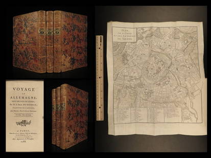
Sold20221788 Voyages Germany MAP Johann Riesbeck Letters Munich Vienna Austria 3v SET1788 Voyages Germany MAP Johann Riesbeck Letters Munich Vienna Austria 3v SET Johann Kaspar Riesbeck was a 18th-century German travel writer best-known for his book Letters from a French traveler in GSee Sold Price
Sold2015A Fine & Rare Map of New York.Bernard Ratzer "Plan of the City of New York". Signed lower right in the plate "T. Kitchin Sculpt" (Kitchin recorded the cartographer's name as Ratzen (sic) rather than Ratzer). The map backed, rolledSee Sold Price
Sold2022Rare map of Chinatown, San Francisco, 1929Heading: -1929 Author: Wong, J.P. Title: Map of San Francisco Chinatown / ????????: ??? / Meiguo Sanfan Shi hua qiao qu: xiang xi tu Place Published: San Francisco Publisher: Date Published:See Sold Price
Sold2022Attributed to Simon Fries (Salzburg, Austria, active 1686 - 1719)Attributed to Simon Fries (Salzburg, Austria, active 1686 - 1719) "Saint Maximus" Carved, gilded and polychromed wooden reliquary bust. Circa 1600. 57 x 48,5 x 26 cm. There is a central locket containSee Sold Price
Sold2021Rare map of private NY sporting reserve 1887Heading: (New York - Tuxedo Park) Author: Bowditch, Ernest W. Title: Tuxedo Park Orange County New York. May, 1887 Place Published: New York Publisher:Endicott & Co. Photo Lith. Date Published: <See Sold Price
Sold2019Rare map of the Bosphorus, 1788Heading: Author: Maire, François Joseph Title: Plan de Constantinople et du Bosphore pour Servir de Renseignement a la Carte des Limites des Trois Empires, ou Theatre de la Guerre Presente Place PubSee Sold Price
Sold2021Rare map of lands beneath Lake Berryessa, Cal.Heading: (California - Napa County) Author: Title: Map of land along the Putah Creek, most of which is now under Lake Berryessa Place Published: No place Publisher: Date Published: Late 19tSee Sold Price
Sold2020RARE map of Cairo, Egypt. With Sphinx and pyramids.Title: RARE map of Cairo, Egypt. With Sphinx and pyramids. c1600 by Matteo Florimi. Siena, Italy Date/Period: c1600 Materials: Copper plate engraved Size: 22 1/2 x 16 1/2 inches. Description: Hand colSee Sold Price
Sold2021Rare map of Oakland with ms. transit lines 1893Heading: (California - Oakland) Author: Dingee, William J. Title: William J. Dingee's Map of Oakland, showing the properties of the Mutual Investment Union. 1893 Place Published: [Oakland?] Publisher:See Sold Price
Sold2022Rare map of Straight of Magellan, 1630Heading: Author: Hondius, Jodocus / Jean Blaeu Title: Freti Magellanici ac novi Freti vulgo Le Maire exactissima delineatio Place Published: Amsterdam Publisher: Date Published: [1630]See Sold Price
Sold2023Rare map of Upper Territories by Mathew Carey, 1814Early and rare map of the old Northwest Territory. In this map the area of Michigan has yet to be understood. The extents of Saginaw Bay and Green Bay are also more or less guessed at. The map reflectSee Sold Price
Sold2020RARE map of SicilyTitle: RARE map of Sicily Date/Period: 1596 Materials: Copperplate engraved Size: 14" x 10 1/4" A beautiful and rare map shows a portrait of king Philip of Spain, and his coat of arms. Excellent condiSee Sold Price
Sold2022Large Rare Map of Waterford Maine by Daniel Chaplin1850, hand colored, 37 x 29.5 inches, sight. Framed, wrinkles and limited splitting.See Sold Price
Sold2020Virginia & Maryland. I land rare map of the ChesapeakeTitle: Virginia & Maryland. I land rare map of the Chesapeake bay. Date/Period: 1732/1736 Materials: Copper plate engraved Dimensions: 13 1/2 x 9” By. H. MOLL. From atlas minor. Published. LondonSee Sold Price
Sold2021Rare map of San Francisco Peninsula 1929Heading: (California - San Francisco Peninsula) Author: Bromfield, Davenport Title: Bromfields Map of the San Francisco Peninsula Place Published: No place Publisher:D. Bromfield Date Published:See Sold Price
Sold2016Rare map of transatlantice cable 1866Heading: Author: Korff Brothers Title: Map of the submarine telegraph between America & Europe with its various communications on the two continents Place Published: New York Publisher: Date PubSee Sold Price
Sold20241572 RARE MAP OF GERMANY by ORTELIUS antique COPPER ENGRAVING RARESize (including margins) 15 1/4 by 20" From: Theatrum oder Schawplatz des Erdbodems. Antwerpen, Gielis Coppens van Diest, 1572 VERY GOOD CONDITION, MINOR WEAR Reserve: $250.00 Shipping: Domestic: FlatSee Sold Price
May 04Trillium Antique Prints & Rare BooksDe Jode, Rare, pub. 1593 - Map of Austria (Austriae Ducatus Seu Pannoniae Superioris?)$100
1 day LeftActivity AuctionsORIGINAL SALZBURG WINDOWS RARE MID CENTURY 1960'S VINTAGE AUSTRIA TRAVEL POSTER$450
May 12Schilb Antiquarian Rare Books1869 ATLAS 42 MAPS America Africa Australia GERMANY Switzerland Sydow RARE$130(3 bids)
7 days LeftMerrill's Auctioneers and AppraisersAlbin Müller-Rundegg (AU 1891-1971) Salzach River Salzburg Austria$200
Featured4 days LeftJasper52RARE MAP, 1762, 15 Cities of the Safavid era Persian Empire by J. B. Homann$600
May 15University ArchivesDeclaration of Independence, Very Early British Publ. in Gentleman's Magazine & Rare Map$1,000
May 16Potter & Potter AuctionsMap to Acquaint You with the Great Mission Bay Project. 194...$125(1 bid)
May 16Potter & Potter AuctionsPictorial Map of Hollywood and Vicinity / Hollywood Film Ca...$125(1 bid)
May 09Hunt and Peck Estate Services, Inc.Jacques Nicolas Bellin Map Of Western Part Of New France Or Canada$200(1 bid)


![Rare map of Oakland with ms. transit lines 1893: Heading: (California - Oakland) Author: Dingee, William J. Title: William J. Dingee's Map of Oakland, showing the properties of the Mutual Investment Union. 1893 Place Published: [Oakland?] Publisher:](https://p1.liveauctioneers.com/642/218849/112379278_1_x.jpg?height=310&quality=70&version=1631923877)
![Rare map of Straight of Magellan, 1630: Heading: Author: Hondius, Jodocus / Jean Blaeu Title: Freti Magellanici ac novi Freti vulgo Le Maire exactissima delineatio Place Published: Amsterdam Publisher: Date Published: [1630]](https://p1.liveauctioneers.com/642/251404/130614760_1_x.jpg?height=310&quality=70&version=1655080506)


