Sold20151 lot of 11 military maps of France for use in WWWI ?1 lot of 11 military maps of France for use in WWWI ?See Sold Price
Sold2023WWII U.S. MILITARY WAR MAPS OF FRANCE - (3)171283 WWII U.S. MILITARY WAR MAPS OF FRANCE - (3) WWII U.S. military war maps of France to include, one sheet 6F/6 Vire France(50000) war map second edition, one sheet 6E/6 Isigny France(50000) war mSee Sold Price
Sold2023U.S. MILITARY FIELD MAPS OF FRANCE 1939-1945 -(3)170302 U.S. MILITARY FIELD MAPS OF FRANCE 1939-1945 -(3) U.S. military field maps of France 1939-1945 to include one France and Belgium (50000) Sittard Field Map Second Edition Sheet 48, One France (5See Sold Price
Sold2023WWII U.S MILITARY WAR MAPS OF FRANCE/BELGIUM - (9)171281 WWII U.S MILITARY WAR MAPS OF FRANCE/BELGIUM - (9) WWII U.S. military war maps of France/Belgium to include one sheet 79 Defenses Vierville-Sur-Mer France (12500) war map, two sheet 31/18 S.E.See Sold Price
Sold2021ROBERT DE VAUGONDY (France, 1688-1766), Map of NorthROBERT DE VAUGONDYFrance, 1688-1766Map of North America "Amerique Septentrionale, dressee, sur les Relations les plus Modernes des Voyaeurs et Navigateurs". Hand-colored engraving, 18.5"See Sold Price
Sold2022Guthrie, William 1805 Map. France divided into Military GovernmentsCopper Engraved Map Published 1805, London for "A New Geographical, Historical and Commercial Grammar..." by William Guthrie. Folds as issued. Paper Size: 10.5 x 8 inch (27 x 21cm) Approx. Some toningSee Sold Price
Sold20181917 British Military Map of Southwest Belgium andReserve Reduced! Title/Content of Map:1917 British Military Map of Southwest Belgium and Northern France (Sheet 28) -- Belgium and France Sheet 28 Date:1917, London Cartographer:British Army GeographiSee Sold Price
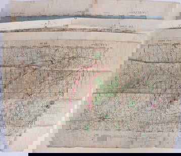
Sold2017[World War One - Maps] WWI Military Maps of North West[World War One - Maps] WWI Military Maps of North West Europe, Belgium and France, Lot of 3 Three Military maps issued by the British Army, Geographical Services. Typical topographic maps with towns,See Sold Price
Sold2022FALL OF FRANCE 1940. German British French Belgian troop positions 1953 mapTITLE/CONTENT OF MAP: 'Stellungskarte West' DATE PRINTED: 1953 IMAGE SIZE: Approx 42.5 x 54.5cm, 16.75 x 21.5 inches (Large); Please note that this is a folding map. TYPE: Vintage military map CONDITISee Sold Price
SoldWW1.British Officers Trench Kit LotLot includes field mirror in case, trench maps of France,Sam Browne Belt with sword frog ,Trench compass and named stop watch in housing.See Sold Price
Sold2023WWII U.S. MILITARY FIELD MAPS 1939-1945 - (4)170301 WWII U.S. MILITARY FIELD MAPS 1939-1945 - (4) WWII U.S. military field maps 1939- 1945 to include one East and West Omaha beach scanned "Bigot" Field maps, one France (12500) Isigny field map,See Sold Price
Sold20211695 Louis of Bourbon Prince of Conde Huguenot Wars1695 Louis of Bourbon Prince of Conde Huguenot Wars v Catholic France MAP Coste Louis of Bourbon was a notable 16th-century Huguenot military leader who was the first Prince of the House of Conde. HisSee Sold Price
Sold2023U.S. MILITARY WWII FIELD MAPS 1943-1944(5)170300 U.S. MILITARY WWII FIELD MAPS 1943-1944(5) U.S. military WWII field maps 1943-1944 to include one original Europe Road Map Series 1 first edition France with name of soldier Caldwell, two WWIISee Sold Price
Sold2021Military Foot Locker and 1918 Map of Vosges Alsace1940's 12th Engineers RY military foot locker chest/trunk of LT. C.H. Kinney with 3 maps of 1927 France including on framed map of 1918 "Vosges Alsace" of allied movement along the front by Carte-CampSee Sold Price
Sold2018Normandy/Ile de France. World War 2 pre-D-Day militaryTITLE/CONTENT OF MAP: 'North west Europe. Rouen-Paris - Army/Air. Sheet 7' The map was published by the (British) War Office in 1943, with magnetic north dated to June 1943 - a year before the D-Day lSee Sold Price
Sold2021Brockhaus (Pub) 1890's Mixed Lot of 14 Antique MapsIncl Poland, North America, Chicago, Atlantic Ocean Routes, France and Military Locations, Australia, Athens, British North America, Balkans, Bohemia, and Alexandria. Lithograph Maps Published 1892-98See Sold Price
Sold2022(CIVIL WAR.) P.S. Duval & Son. Military Map of the United States & Territories(CIVIL WAR.) P.S. Duval & Son. Military Map of the United States & Territories Showing the Location of the Military Posts, Arsenals, Navy Yards, & Ports of Entry. Hand-colored lithographed pocket mapSee Sold Price
Sold2023Johnson's New Military Map of the United States. Forts Posts divisions 1861Title: Johnson's New Military Map of the United States. Forts Posts divisions 1861 Description: Johnson's New Military Map of the United States showing the Forts, Military Posts & all the Military DivSee Sold Price
Sold2021Phelps & Watson's Historical and Military Map of thePublication Date: 1863-06-29 Title: Phelps & Watson's Historical and Military Map of the Border & Southern States. Cartographer: PHELPS/WATSON Publisher: PHELPS & WATSON Height: 25.5 Width: 35.5 Map sSee Sold Price
2021Francis Bernard 1766 Military Commission DocumentA 1766 military commission document bearing the signature of Sir Francis Bernard, dating to reign of King George III in the Massachusetts Bay Colony of New England, 20"h x 23"w with frameSee Sold Price
Sold2016[Wall map] FranceCarte de la France, 1790.Incisione in coloritura coeva, 1200x1160 mm.See Sold Price
Sold2021CIVIL WAR-ERA JOHNSON'S MILITARY MAP UNITED STATESFramed engraving with color on paper, "Johnson's New Military Map of the United States, Showing the Forts, Military Posts & c., with Enlarged Plans of Southern Harbors from Authentic Data Obtained atSee Sold Price
Sold2022Great 1863 Civil War Military Map of U. S. by Johnson & WardWhile America was involved with the Civil War, atlas publishers like Johnson and Ward produced detailed maps to capitalize on the nation’s interest in that conflict. This is the more desirable of thSee Sold Price
Sold20221789 military map of American Northeast1789 military map of American Northeast by Thomas ConderThis map was originally in the two volume book set by Thomas Anburey in this auction, lot 144. Frame: 20" x 20" Painting: 15 1/8" x 16 1/2" ThomSee Sold Price
5 days LeftHermann Historica GmbH"Operation Chariot" - a military map of the 22nd Naval Flak Regiment, March 27/28, 1942€720
May 23Potter & Potter Auctions[FRENCH MILITARY BELT BUCKLES]. Pair of French Officer’s Be...$80(1 bid)
May 23Potter & Potter Auctions[FRENCH MILITARY BELT BUCKLES]. French Officer’s Double Lio...$80(1 bid)
2 days LeftJasper521942 Myra Z Barnes Map of French Quarter, New Orleans -- Le Vieux Carre de la Nouvelle Orleans$95


![[World War One - Maps] WWI Military Maps of North West: [World War One - Maps] WWI Military Maps of North West Europe, Belgium and France, Lot of 3 Three Military maps issued by the British Army, Geographical Services. Typical topographic maps with towns,](https://p1.liveauctioneers.com/46/113409/58240767_1_x.jpg?height=310&quality=70&version=1512492316)


![[Wall map] France: Carte de la France, 1790.Incisione in coloritura coeva, 1200x1160 mm.](https://p1.liveauctioneers.com/3336/90951/46934974_1_x.jpg?height=310&quality=70&version=1473763184)


![[EPHEMERA]. Group of Booklets, Magazines, Postcards, Brochu... (1 of 1)](https://p1.liveauctioneers.com/928/328184/176813372_1_x.jpg?height=282&quality=70&version=1714496988)
![[COLOR PLATE BOOK]. KELLY, Christopher. History of the Fren... (1 of 3)](https://p1.liveauctioneers.com/928/328184/176813585_1_x.jpg?height=282&quality=70&version=1714496988)


![[FRENCH MILITARY BELT BUCKLES]. Pair of French Cavalry Offi... (1 of 1)](https://p1.liveauctioneers.com/928/328184/176813497_1_x.jpg?height=282&quality=70&version=1714496988)
![[FRENCH MILITARY BELT BUCKLES]. Pair of French Officer’s Be... (1 of 1)](https://p1.liveauctioneers.com/928/328184/176813496_1_x.jpg?height=282&quality=70&version=1714496988)
![[FRENCH MILITARY BELT BUCKLES]. French Officer’s Double Lio... (1 of 1)](https://p1.liveauctioneers.com/928/328184/176813495_1_x.jpg?height=282&quality=70&version=1714496988)


![[FRENCH MILITARY UNIFORM PIECES]. Pair of First Empire Fren... (1 of 1)](https://p1.liveauctioneers.com/928/328184/176813498_1_x.jpg?height=282&quality=70&version=1714496988)
