Sold2021Shearer's Map of York County, PA 1860Measures approx. 5' by 5'. It has lithography of important buildings along border; has some water damage and is fractured at top.See Sold Price
Sold2021Shearer's Map of York County, PA 1860Measures approx. 5' by 5'. It is a map of York County, PA with lithographs of important buildings on border. It has tape on Spring Garden section, as well as tape covering entire top section, approx.See Sold Price
Sold2024Hardin’s 1893 HERKIMER COUNTY & 1860 NY GAZETTEER.2 vols. French, J. H. Gazetteer of the State of New York. Syracuse: R. Pearsall Smith, 1860. Large octavo, orig. gilt-stamped leather-backed cloth boards, engraved steel plates, lacks folding map. SpiSee Sold Price
Sold2023M. Dripps 1860 Map New York City County & Vacinity By M. DrippsM. Dripps 1860 Map New York City County & Vacinity By M. Dripps 22.5" x 30"See Sold Price
Sold2022Two 1860 Maps of New York City and CountyHeading: (New York) Author: Title: Map of the City & County of New York. 1860. Place Published: New York Publisher:Geo. Hayward Date Published: 1860 Description: 2 steel-engraveSee Sold Price
Sold20211860 York County MapFrom actual surveys by D.J. Lake. Published by W.O. Shearer & D.J. Lake. Includes business directory. Overall size 60" wide X 60" high. Canvas with losses and is brittle.See Sold Price
Sold2021Antique 1858 Wall Map of Columbia County,NY New YorkLarge antique c.1858 map of Columbia county New York. This large map has lots of great details. It is perfect for anyone interested in local Hudson Valley history. The dimensions are 57in x 66in x 1.5See Sold Price
Sold2019LARGE WALL MAP ULSTER COUNTY NEW YORKLARGE WALL MAP ULSTER COUNTY NEW YORK-OLIVER TILLSON, C. 1853 44" X 54"See Sold Price
Sold2023An 1860 Map, Counties of New York, New Hampshire, Etc...Hand colored lithograph, by Samuel Augustus Mitchell (1790-1868). :County Map of the States of New York, New Hampshire, Vermont, Massachusetts, Rhode Island and Connecticut". Dimensions:15 1/2" x 23 1See Sold Price
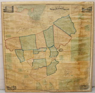
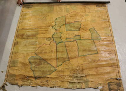
Sold2022MAP OF NORTHAMPTON COUNTY, PA 1860LINEN BACKED MAP MOUNTED ON BACKBOARD UNDER PLEXIGLASS (NO FRAMEWORK). SMITH,GALLUP & CO. PUBLISHERS, PHILADELPHIA, 1860. MEASURES 60" X 58". Terms & Conditions: Pick-up for this Auction will be WedneSee Sold Price
Sold2022MAP OF NORTHAMPTON COUNTY, PA 1860LINEN BACKED MAP. SMITH, GALLUP & CO. PUBLISHERS, PHILADELPHIA, 1860. MEASURES 56" X 57" Terms & Conditions: Pick-up for this Auction will be Wednesday August 3rd and Thursday August 4th from 9:00am tSee Sold Price
Sold2021Antique 1858 Wall Map,Dutchess County,NY Rhinebeck,EtcAntique 1858 Wall Map,Dutchess County,NY Rhinebeck,Etc. This Large detailed antique map of Dutchess county New York is dated 1858. This large map has lots of great little details including drawings anSee Sold Price
Sold2021Large Antique Hanging Map of Columbia County NY 1858Large Antique Hanging Map of Columbia County New York from 1858. Shows details and insets of towns and villages in Columbia county. Has a top piece made to hang on the wall. Has a beautiful patina andSee Sold Price
Sold20181876 Mitchell Map of New York -- County Map of theReserve Reduced! Title/Content of Map: 1876 Mitchell Map of New York -- County Map of the State of New York Date: 1876 Philadelphia Cartographer: S Mitchell Size: 13.5 x 21.3 in. A very nice, large maSee Sold Price
Sold2020Roadmaps and EphemeraLot includes an Esso and a Gulf map, a large selection of American and international road maps from 1960s and 1970s, Sing a Song player book with xylophone, 25c Steel Pier program, a York PA bank bag,See Sold Price
Sold2018LARGE ANTIQUE HAND COLORED MAP JEFFERSON COUNTY NYLarge antique hand colored map of Jefferson County, New York. Circa 1855. Framed in large wooden frame and laid down to canvas backing. Condition: mounted/laid on canvas for preservation, some areas rSee Sold Price
Sold2021Large Groupings of Letters and Bill HeadsMostly Wellsboro Pennsylvania. Also includes other PA counties, New York and Virginia. IMPORTANT: Before bidding, please read the terms and conditions. When you registered for the auction you agreed tSee Sold Price
Sold2020(NEW YORK – DUTCHESS COUNTY.) Large group of(NEW YORK – DUTCHESS COUNTY.) Large group of manuscript maps and surveys of properties in and around Fishkill and Wappingers Falls. Approximately 40 mostly manuscript land surveys on various wovSee Sold Price
Sold20191860 Dutton / Walling Case Map of Boston -- Map ofReserve Reduced! Title/Content of Map: 1860 Dutton / Walling Case Map of Boston -- Map of Boston and the County Adjacent Date: 1860 New York / Boston Cartographer: E Dutton / H Walling Size: 41.3 x 30See Sold Price
Sold2020HYDE, E. BELCHER. Westchester County. State of NewHYDE, E. BELCHER. Westchester County. State of New York. Also a portion of the State of Connecticut Embracing the Towns of Greenwich, Stamford, Darien, New Canaan, Ridgefield. Large lithographed map oSee Sold Price
Sold2021Dolph & Stewart 30s Map Columbia County NY Large FolioMap of Columbia County with Eastern part of Greene County, New York, by Dolph & Stewart, circa 1930s. This is a oversized hardcover bound version of what would be tiles from a large wall-mounted mSee Sold Price
Sold2021Dolph & Stewart 30s Map Columbia County NY Large FolioMap of Columbia County with Northern part of Greene County, New York, by Dolph & Stewart, circa 1930s. This is a oversized hardcover bound version of what would be tiles from a large wall-mountedSee Sold Price
Sold2024Map of the US, Colton, 1874 [179353]The New County map of the United States of America,[x=#8221/] drawn, engraved and printed by G. W. and C. B. Colton & Co., New York 1874. Very large multicolor map, linen back in original Colton bindiSee Sold Price
Sold2016KLAUS IHLENFELD Two large sculpturesKLAUS IHLENFELD (b. 1934) "Espalier" and "Memorial," Berks County, PA, 2000-01 Patinated bronze Both marked 18 1/2" x 13 1/2" x 4 1/4", 16 1/2" x 7" x 7" Provenance: Sotheby's New York, The CollectionSee Sold Price
May 03Conestoga Auction Company Division of Hess Auction GroupAntique Oil on Canvas Still Life Painting.$50
5 days LeftJasper521867 Beers Map of New York City Area -- Map of New York and Vicinity Accompanying "Atlas of New York$200
6 days LeftJasper52Oceania or Islands in the Pacific Ocean. Polynesia Australasia SWANSTON 1860 map$55
4 days LeftFreeman's | HindmanA glazed and slip-decorated redware plate, After Benjamin Bergey (1797-1854), Franconia Township,$400(1 bid)
5 days LeftDoyle New YorkGoerck's 1785 working survey of the Common Lands that became Fifth Avenue$1,000
May 16Potter & Potter AuctionsBOURNE, Emma (1906 – 1986). America – A Nation of One Peopl...$125(1 bid)
May 03Conestoga Auction Company Division of Hess Auction GroupPA 19th C. Feather Grain-Painted Doll Cradle.$50
May 16Zikorn Arts & History ObjectsTina Barney, Signed First Edition 2017 Comprehensive Monograph$200
11 hrs LeftAlexander Historical Auctions LLCCAPTURED MAP OF VERDUN, USED BY COL. WILLIAM J. DONOVAN$100


![Map of the US, Colton, 1874 [179353]: The New County map of the United States of America,[x=#8221/] drawn, engraved and printed by G. W. and C. B. Colton & Co., New York 1874. Very large multicolor map, linen back in original Colton bindi](https://p1.liveauctioneers.com/2699/324080/174413237_1_x.jpg?height=310&quality=70&version=1711759488)


