Sold2020Borneo and the Indian ArchipelagoBorneo and the Indian Archipelago Marryat, Frank S. London: Longman, Brown, Green, and Longmans, Paternoster-Row (1848). English Text/Edition 232 pages 62 illustrations Hardcover 27,3 x 19,5 x 3,8 cm.See Sold Price
Sold2022Exploring Borneo in 1840sHeading: Author: Marryat, Frank S. Title: Borneo and the Indian Archipelago, with Drawings of Costume and Scenery Place Published: London Publisher:Longman, Brown, et al. Date Published: 184See Sold Price
Sold2019Exploring Borneo in 1840'sHeading: Author: Marryat, Frank S. Title: Borneo and the Indian Archipelago, with Drawings of Costume and Scenery Place Published: London Publisher:Longman, Brown, et al. Date Published: 184See Sold Price
Sold2017Weller: Antique Map of Indian Archipelago, 1863Title/Content of Map: 'The Indian Archipelago' East Indies. The map shows the Kingdom of Sarawak, a state in Borneo established by Sir James Brooke in 1841 by receiving independent kingdom status fromSee Sold Price
Sold2022Earl, The Eastern Seas w/ four mapsHeading: Author: Earl, George Windsor Title: The Eastern Seas, or Voyages and Adventures in the Indian Archipelago in 1832-33-34, Comprising a Tour of the Island of Java- Visits to Borneo, the MalaySee Sold Price
Sold2016Keppel visits to the Indian Archipelago 1853Heading: Author: Keppel, Henry Title: A Visit to the Indian Archipelago, in H.M. Ship Mæander Place Published: London Publisher:Richard Bentley Date Published: 1853 Description:See Sold Price
Sold2017The Journal of the Indian Archipelago, 1850Heading: Author: Logan, J.R. , editor Title: The Journal of the Indian Archipelago and Eastern Asia. Vol. IV Place Published: Singapore Publisher:Printed for the editor by G.M. Frederick Date PuSee Sold Price
Sold2024Blackie (Pub) 1882 Folio Map. East Indies - Indian ArchipelagoLithograph Map Published 1882 by Blackie & Son, London for "The Comprehensive Atlas & Geography of the World" by W. G. Blackie. Centre fold as published. Paper Size: 22 x 15 inch (56 x 38cm) Tear at bSee Sold Price
Sold2018Indian Archipelago and Further India. Including Burmah,Title/Content of Map: Indian Archipelago and Further India. Including Burmah, Siam, Anam &C. Date: 1879 Cartographer: BARTHOLOMEW, J. Size: 16.25X21.5 Topography. Larger detailed map. Dry. Please noteSee Sold Price
Sold2018East Indian ArchipelagoReserve Reduced! Title/Content of Map: East Indian ArchipelagoDate: 1890 Cartographer: BARTHOLOMEW, JOHN & CO. Material/Medium: MACMILLAN & CO. Size: 11.3 x 16.3 inches By J. Bartholomew, F.R.G.S. 50See Sold Price
Sold2020Philip, George C1900 Mixed Lot of 8 MapsIncl France, Holland/Belgium, East Indian Archipelago, China/Japan, Africa Physical, Mexico, West Indies/Central America, and South America Physical. Lithograph Maps Published C1900, London for "PhiliSee Sold Price
Sold2019Blackie & Weller 1882 Map of the East Indies, Indonesia"The Indian Archipelago" Lithograph Map Published 1882 by Blackie & Son, London for "The Comprehensive Atlas & Geography of the World" by W. G. Blackie. Maps by Edward Weller. Centre fold as issued. PSee Sold Price
2023Lambis Shell Harpago Arthriticus Shell Mahe Island, Seychelles Archipelago, Indian Ocean12.5x7cm Weight: 172 grams (Before Packing) A bargain hunter's, fixer-upper's, and pack-rat's dream come true! Our Ten2Go "warehouse" style auction presents over thousand lots in a fast-paced old-stylSee Sold Price
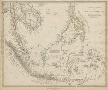
Sold2020MALAY ARCHIPELAGO Indonesia Malaysia PhilippinesTITLE/CONTENT OF MAP: 'EASTERN ISLANDS OR THE MALAY ARCHIPELAGO. Sumatra, Java, Borneo, etc' The top image on the right hand side shows the entire map. To view a close up of the map showing the levelSee Sold Price
Sold2020MALAY ARCHIPELAGO Indonesia Malaysia PhilippinesTITLE/CONTENT OF MAP: 'EASTERN ISLANDS OR THE MALAY ARCHIPELAGO. Sumatra, Java, Borneo, etc' The top image on the right hand side shows the entire map. To view a close up of the map showing the levelSee Sold Price
Sold2018Eastern Islands Or Malay ArchipelagoMap: Eastern Islands Or Malay Archipelago Date: 1852 Cartographer: WALKER, J. & C. Publisher: GEORGE COX/S.D.U.K. Size (inches): 12.5X16 Map showing southern Siam, Archipelago Filipino, Celebes, BorneSee Sold Price
Sold2019INDIAN OCEAN Madagascar Seychelles Maldives MauritiusReserve Reduced! TITLE/CONTENT OF MAP: 'ISLANDS IN THE INDIAN OCEAN. Madagascar, Amirantes, Seychelle Archipelago, Socotra, Lakadive Islands, Maldive Islands, Andaman Isles, Nicobar Isles, Chagos GrouSee Sold Price
Sold2016Original Imray East India Archipelago Chart No. 4Imray & Son 1880 marine chart of East India Archipelago, showing the western route to China, marine chart No. 4. Stamped with 1881. Shows Borneo, and detailed marine charts of Bruni and Labouan, PalawSee Sold Price
Sold2017Framed Kuna Indian Bird MolaFramed Kuna Indian Bird Mola, under glass and matted, visual measures 17'' x 13'', FYI: ''The Kuna Indians are a strongly-knit tribal society living on a chain of islands called San Blas Archipelago,See Sold Price
Sold2021MALAY ARCHIPELAGO/EAST INDIA ISLANDS PhilippinesTITLE/CONTENT OF MAP: 'Malay Archipelago or East India Islands' Vignettes: Victoria Mount - New Guinea; Near Sarawak - Borneo; Natives of New Guinea; The Bee Bear. The map covers the area from Burma aSee Sold Price
Sold2022A Fritz Scholder painting, 'Hollywood Indian #2,' 1972Fritz Scholder Luiseño, (1937-2005), 'Hollywood Indian #2,' 1972, acrylic on canvas, signed upper right; titled, dated, and signed again verso. height 40in, width 30in Footnotes: Provenance HenriSee Sold Price
Sold2020Fritz Scholder (American, 1937-2005) Indian Messiah,Fritz Scholder (American, 1937-2005) Indian Messiah, 1975 oil on canvas signed Scholder (lower right) 80 x 68 inches Provenance: Jack O'Grady Galleries, Inc, Chicago, Illinois, 1975 Exhibitions: EversSee Sold Price
Sold2022ANDY WARHOL - II.382 PLAINS INDIAN SHIELD SILKSCREEN 1986ANDY WARHOL "PLAINS INDIAN SHIELD FS II.382" MEDIUM: SCREENPRINT ON LENOX MUSEUM BOARD SIZE: 36 X 36 INCHES EDITION: OF 250 YEAR: 1986 SIGNATURE: HAND SIGNED AND NUMBERED BY THE ARTIST CERTIFICATE OFSee Sold Price
Sold2023Large chart of Pacific & Indian Oceans 1813Heading: Author: Espinosa y Tello, Josef Title: Carta general para las navegaciones a la India Oriental por el Mar del Sur y el Grande Oceano que separa el Asia de la America Place Published: LondonSee Sold Price
Featured6 days LeftJasper52FRENCH INDOCHINA & DUTCH EAST INDIES Siam Burma Penang Manila Singapore 1912 map$20
5 days LeftHannam's Auctioneers LtdA LARGE 19TH CENTURY COCO DE MER COUNTRY HOUSE NUT CASKET AND COVER of naturalistic form. 28 cm x 28£260
Jun 01Richmond AuctionsRare Indian Lake Ohio Park Die Cut SSP Sign w/ Native American & Arrow Graphic$1,100(5 bids)
4 days LeftKensington Estate AuctionNative American Indian Beaded And Painted Hide Medicine Bag w/ Fringe$325(5 bids)
3 days LeftRich Penn AuctionsMotorcycle Items (2), Indian Mascot vintage chrome fender light w/mask insert & a bottle opener,$70(3 bids)
2 days LeftFontaine's Auction GalleryTiffany Studios "American Indian" Desk Clock, Chelsea Clock Co.$1,200(1 bid)