Sold20201750 c. Schenk Map of Eastern Germany Centered onTitle: 1750 c. Schenk Map of Eastern Germany Centered on Dresden -- Dem Durchlauchtigsten Fursten und Herrn Herrn Friedrich Augusto... Cartographer: P Schenk II Year/Place: 1750 c., Amsterdam Size: 19See Sold Price
Sold20211720 c. Homann Map of Central Germany Near Fulda -- S.Title: 1720 c. Homann Map of Central Germany Near Fulda -- S. R. I. Principatus Fuldensis in Buchonia… Cartographer: J Homann Year / Place: 1720 c., Nurnberg Map Dimension (in.): 19.1 X 22.6 in. ThiSee Sold Price
Sold20201720 c. Homann Map of Central Germany's ThuringianTitle: 1720 c. Homann Map of Central Germany's Thuringian Forest Area -- Tabula Geographica in qua ... Principatus Gotha, Coburg et Altenburg Cartographer: J Homann Year/Place: 1720 c., Nurnberg DimenSee Sold Price
Sold20191710 SENEX MAP OF NORTH AND CENTRAL AMERICAc. 1710, Map: “NORTH AMERICA,” & “CENTRAL AMERICA,... Corrected from the Observations Communicated to the Royal Society at London And the Royal Academy at Paris,” by John SenexSee Sold Price
Sold2019Gilles Robert de Vaugondy (1688-1766), "An Accurate MapGilles Robert de Vaugondy (1688-1766), "An Accurate Map of North America," matted, c. 1760, hand colored, H.- 8 in., W.- 12 in.See Sold Price
Sold2018Germany's north central region. Insert of Hamburg &Germany's north central region. Insert of Hamburg & Bremen 1861 J.H. Colton 17 1/2" x 13 3/4" Hand colored steel engraved Map. From 'Colton's General Atlas.' Published in New York. Please note that thSee Sold Price
Sold2017[MAP] FREDERICK DE WIT (DUTCH, 1630-1706)Map of North Rhine-Westphalia, Germany, c. 1680See Sold Price
Sold20181944 British Air Force Escape Map (C & D) of France,Reserve Reduced! Title/Content of Map:1944 British Air Force Escape Map (C & D) of France, Benelux, Switzerland and Germany -- Sheet C Holland, Belgium, France (Northeast), Germany (West & Central) [vSee Sold Price
Sold20241730 MAP of GERMANY antique 14 by 20"A Correct Map of the North East Part of Germany containing the Electorates of Saxony and Brandenburg, and the duchies of Silesia, Mecklenburg, Pomerania & c. Drawn from the best authorities and adjustSee Sold Price
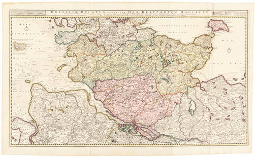
Sold2016Large map of Holstein, Germany 1720Heading: Author: Visscher, Nicolas Title: Holsatiae Ducatus Vernadule das Hertzogtum Holetein... Place Published: Amsterdam Publisher:Pieter Schenk, Jr. Date Published: c.1720 DescriptSee Sold Price
Sold20211760 Kitchin Map of Moravia: Austria and Czechia -- ATitle: 1760 Kitchin Map of Moravia: Austria and Czechia -- A Map of the Marquisate of Moravia with North.n Part of Arch Duchy of Austria Cartographer: T Kitchin Year/Place: 1760 c., London Dimensions:See Sold Price
Sold2022Early 20th c Travel Guides w/ MapsEarly 20th c travel guides with fold-out maps (8 pcs), including Baedecker's Central Italy, Northern Italy, Northern Germany, Paris and Environs, London and Environs, Switzerland, Bennett's Norway (2See Sold Price
Sold20164 Maps: 1760 N. Am.; Botanic Geo.; Eur.; OK Terr.Four Antique Maps; a French 1760 Map of North American ''AMÉRIQUE SEPTENTRIONALE...1750'' Paris: S. Robert De Vaugondy, c. 1750 (1st edition, dated in the cartouche; "Outlines of Botanical Geography"See Sold Price
Sold2020Bartholomew, John 1922 Lot of 12 European MapsOne Map of Asia continent and the others of European Countries. Incl British Isles, Belgium/Holland, Spain/Portugal, North Italy/Austria, Greece, South Italy, Central European States, and Germany SoutSee Sold Price
Sold2024CENTRAL ASIA. Bokhara Russian Turkestan Tomsk Great Horde Turgan. LETTS 1883 mapTITLE/CONTENT OF MAP: 'Russia in Asia, Turkestan, &c; Inset maps of Kara Sea; Continuation of Ieniseisk to the North Point of Asia No 1' DATE PRINTED: 1883 IMAGE SIZE: Approx 43.5 x 36.0cm, 17.25 x 14See Sold Price
Sold20211860 Ettling Map of United States -- United States ofTitle: 1860 Ettling Map of United States -- United States of North America (Eastern & Central) Cartographer: T Ettling Year / Place: 1860 c., London Map Dimension (in.): 33.5 X 35.5 in. joined This isSee Sold Price
Sold2020Maps C1860-1910 Mixed Lot of 10Mixed Lot of Lithograph and Engraved Maps. Incl Europe, Canada, Germany, Channel Islands, Asia Minor, USA, Chile/Argentina, Mexico, North America, and Central America. Examples by Estevanez, Rapkin, BSee Sold Price
Sold202118th C Large Handcolored Mercator Map GermanyLarge beautifully handcolored map of Braunswyck and Meydburg after Gerard Mercator circa 1640, this being an 18th century restike.. Printed at Amsterdam. Measures 23 x 19". Fine, reinforced central veSee Sold Price
Sold202218th C. MAPS OF NORTH AMERICA & CARIBBEAN (2 MAPS)Includes: Brian de la Tour, Louis. L'AMERIQUE DRESSEE POUR L'ETUDE DE LA GEOGRAPHIE (Paris, 1764).Copperplate engraved map of North and South America. Hand colored. Matted and framed. H. 11", W. 12" BSee Sold Price
Sold201717TH C. MAP OF GERMANY TYPUS FRISIAE ORIENTALISDimensions: (Frame) H 19.5" x W 23.75" (Sight) H 15" x W 19.5" Condition: Holes to map. Discoloration and stains to paper. Wear to frame.See Sold Price
Sold2019Laurie & Whittle Map of North & Central ItalyLaurie & Whittle Map of North & Central Italy. Engraved map of North & Central Italy by D'Anville, published by Laurie & Whittle. Professionally matted and framed. Frame measures 38.5 inches x 31 inchSee Sold Price
Sold2018Mitchell: Antique Map of North & Central America, 1852Title/Content of Map: 1852 Mitchell Map of North and Central America -- Map of North America Date Printed: 1852, Philadelphia Cartographer: S Mitchell Size: 10.6 x 8 in. A very nice map of North AmeriSee Sold Price
Sold2023MAP: North West Germany Map drawn by Edward Weller FRGS./ Duke Str. BloomsburyDescription: North West Germany Map drawn and Engraved by Edward Weller/ Duke Str. Bloomsbury 1800S. Copy. Material: PaperMeasurement approximate: 21 x 15 (Inches)See Sold Price
Sold2023(SOUTH AMERICA.) Joseph Vasquez; and Manuel Sobreviela. Plan Del Curso de los Rios Huallaga y(SOUTH AMERICA.) Joseph Vasquez; and Manuel Sobreviela. Plan Del Curso de los Rios Huallaga y Ucayali, y de la Pampa del Sacramento. Engraved map of north central Peru with figural ornamentation, a deSee Sold Price
5 days LeftNY Elizabeth 1760 WORLD'S HISTORY ON OLD GERMAN VELLUM, ILLUSTRATED WITH A MAP OF CENTRAL ASIA$100
4 days LeftJasper521700 Schenk Map of Russian Empire -- La Russie Blanche ou Moscovie Divisee Suivant l'Estendue des$240
Jul 16BADO e MART AUCTIONSMap of North America. Amérique du Nord. Atlas élémentaire simplifié.€150
5 days LeftJasper52CENTRAL AMERICA & CARIBBEAN. West Indies Mexico &c. Inset Panama Canal 1890 map$25
4 days LeftJasper521720 antique MAP of LOWER SAXONY GERMANY 18th CENT. Circulus Saxoniae inferioris$75


![[MAP] FREDERICK DE WIT (DUTCH, 1630-1706): Map of North Rhine-Westphalia, Germany, c. 1680](https://p1.liveauctioneers.com/3820/102962/52635921_1_x.jpg?height=310&quality=70&version=1492789342)