Sold20201720 c. Homann Map of Central Germany's ThuringianTitle: 1720 c. Homann Map of Central Germany's Thuringian Forest Area -- Tabula Geographica in qua ... Principatus Gotha, Coburg et Altenburg Cartographer: J Homann Year/Place: 1720 c., Nurnberg DimenSee Sold Price
Sold20211720 c. Homann Map of Central Germany Near Fulda -- S.Title: 1720 c. Homann Map of Central Germany Near Fulda -- S. R. I. Principatus Fuldensis in Buchonia… Cartographer: J Homann Year / Place: 1720 c., Nurnberg Map Dimension (in.): 19.1 X 22.6 in. ThiSee Sold Price
Sold20201720 c. Homann Map of Belgium, Northern France andTitle/Content of Map: 1720 c. Homann Map of Belgium, Northern France and Western Germany -- Arena Martis in Belgio, Qua Provinciae X. Catholicae Inferioris Germaniae Cartographer: J Homann Year/Place:See Sold Price
Sold20201720 c. Homann Map of Poland, Lithuania to the BlackTitle/Content of Map: 1720 c. Homann Map of Poland, Lithuania to the Black Sea -- Regni Poloniae Magnique Ducatus Lithuaniae Nova et Exacta Tabula Cartographer: J Homann Year/Place: 1720 c. Nurnberg SSee Sold Price
Sold20211720 c. Homann Map of Northern Poland to Lithuania --Title: 1720 c. Homann Map of Northern Poland to Lithuania -- Regnum Borussiae Gloriosis auspicys Serenissimi et Potentissimi Princ Friderici III Cartographer: J Homann Year / Place: 1720 c., NurnbergSee Sold Price
Sold20211720 c. Homann Map of Norteast Italy, Venice IncludedTitle: 1720 c. Homann Map of Norteast Italy, Venice Included -- Dominii Veneti cum vicinis Parme Mutinae Mantuae et Mirandole Statibus Cartographer: J Homann Year / Place: 1720 c., Nurnberg Map DimensSee Sold Price
Sold20201720 c. Homann Map of Benelux -- Tabula GeneralisTitle/Content of Map: 1720 c. Homann Map of Benelux -- Tabula Generalis Totius Belgii qua Provinciae XVII. Infer. Germaniae olim sub S.R.I. Circulo BurgundiaeÂ… Cartographer: J Homann Year/Place: 1See Sold Price
Sold20211720 c. Homann Map of Northern Poland to Lithuania --Title: 1720 c. Homann Map of Northern Poland to Lithuania -- Regnum Borussiae Gloriosis auspicys Serenissimi et Potentissimi Princ Friderici III Cartographer: J Homann Year / Place: 1720 c., NurnbergSee Sold Price
Sold20211720 c. Homann Map of Czech Republic, Slovakia andTitle: 1720 c. Homann Map of Czech Republic, Slovakia and Poland -- Regni Bohemiae, Ducatus Silesiae, Marchionatus Moraviae et Lusatiae. Tabula Generalis Cartographer: J Homann Year / Place: 1720 c.,See Sold Price
Sold20221720 c. Homann Map of Czech Republic, Slovakia and Poland -- Regni Bohemiae, Ducatus Silesiae,Title: 1720 c. Homann Map of Czech Republic, Slovakia and Poland -- Regni Bohemiae, Ducatus Silesiae, Marchionatus Moraviae et Lusatiae. Tabula Generalis Cartographer: J Homann Year / Place: 1720 c.,See Sold Price
Sold20201720 c. Homann Map of Paris and Surroundings -- AgriTitle: 1720 c. Homann Map of Paris and Surroundings -- Agri Parisiensis Tabula partieularis, qua maxima Pars Insulae Franciae, seu Regiae celeberrimaeq Parisiorum Urbis vicina Regio in fuas CastellaniSee Sold Price
Sold20221720 c. Homann Map of Denmark -- Regni Daniae, in quoTitle: 1720 c. Homann Map of Denmark -- Regni Daniae, in quo sunt Ducatus Holsatia et Slesvicum, Insulae Danicae, Provinciae Iutia Scania Blekingia &c Nova Tabula Cartographer: J Homann Year / Place:See Sold Price
Sold20211720 c. Homann Map of Luxembourg -- Ducatus LuxemburgiTitle: 1720 c. Homann Map of Luxembourg -- Ducatus Luxemburgi tam in Maiores quam Minores Ejusdem Ditiones Accurate Distinctus et Exhibitus Cartographer: J Homann Year / Place: 1720 c., Nurnberg Map DSee Sold Price
Sold2022Homann. Amplissimae Regionis Mississipi. c1720.[Map/America] Homann, Johannes Baptist. Amplissimae Regionis Mississipi. Nuremberg, c.1720. Hand colored copper-engraved map. Homann's important and widely disseminated map of the southeast of North ASee Sold Price
Sold2018Homann: Antique Map of Denmark, 1720Title/Content of Map: 1720 Homann Map of Denmark -- Regni Daniae in quo sunt Ducatus Holsatia et Slesvicum Insulae Danicae Provinciae Iutia Scania Blekingia Nova Tabula Date Printed: 1720 c Nurnberg CSee Sold Price
Sold20231720 Handcolored Homann Map TOTIUS AMERICAE SEPTENTRIONALIS ET MERIDIONALIS NOVISSIMA REPRAESENTATIOHistoric Maps Beautiful Hand-Colored Engraved Map by Johann Homann Titled: "TOTIUS AMERICAE SEPTENTRIONALIS ET MERIDIONALIS NOVISSIMA REPRAESENTATIO..." c. 1720 Hand-Colored Map titled, "TOTIUS AMERICSee Sold Price
Sold2023Guillaume de l'Isle Map of Germany and Western Europe.‘L'Allemagne, Dressee sur les Obfervations de Tycho-Brahe de Kepler de Snellius’, image 19 x 24.5 inches, engraved by Jean Baptiste Liebaux, c. 1720, hand tinted, framed, 29 x 34.5 incSee Sold Price
Sold2022Johann Baptist Homann - 3 MapsAfrica, Asia and Europe Nuremberg, c. 1720 each 23"x19 1/2", framed 31"x28"See Sold Price
Sold2019Two Johann Baptist Homann (1661-1774) Maps, "VirginiaTwo Johann Baptist Homann (1661-1774) Maps, "Virginia Marylandia et Carolina in America Septatrionalis," c. 1720, hand colored, H.- 23 in., W.- 19 in. (2 Pcs.)See Sold Price
Sold20181944 British Air Force Escape Map (C & D) of France,Reserve Reduced! Title/Content of Map:1944 British Air Force Escape Map (C & D) of France, Benelux, Switzerland and Germany -- Sheet C Holland, Belgium, France (Northeast), Germany (West & Central) [vSee Sold Price
Sold2017J.B. Homann, 18th c. map of IrelandJ.B. Homann, 18th c. map of Ireland, Johann Baptist Homann (German,1664-1724), "Hiberniae Regnum tam in Praecipuas Ultoniae, Connaciae, Laceniae et Momoniae quam in Minores", c. 1720, 24"h x 20.5"w (sSee Sold Price
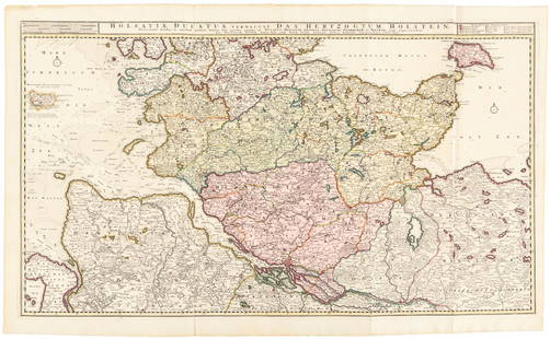
Sold2016Large map of Holstein, Germany 1720Heading: Author: Visscher, Nicolas Title: Holsatiae Ducatus Vernadule das Hertzogtum Holetein... Place Published: Amsterdam Publisher:Pieter Schenk, Jr. Date Published: c.1720 DescriptSee Sold Price
Sold2017Homann: Antique Map of Belgium Holland Germany FranceTitle: Map of Belgium, Holland, Germany, and France by Homann Date: c 1747 Medium: Hand Colored Copper Plate Engraving Dimensions (in.): 22.5 x 20 No Reserve: This lot starts at $1 and has no reserveSee Sold Price
Sold2019Pomerania Central Europe Antique MapDucatus Pomeraniae. Hand-colored engraved map. J.B. Homann, Nuremberg, 18th C.. 21" x 24".See Sold Price
1 day LeftJasper521720 antique MAP of LOWER SAXONY GERMANY 18th CENT. Circulus Saxoniae inferioris$75
1 day LeftJasper521890 c. Clemens Wooden Puzzle Map of the US -- Clemens' Silent Teacher Dissected Map of the United$240
May 14Hermann Historica GmbHA Greek silver phiale with lotus decoration, 6th - 5th century B.C.€2,600
Featured1 day LeftJasper52RARE MAP, 1762, 15 Cities of the Safavid era Persian Empire by J. B. Homann$600
1 day LeftJasper521598 Munster Map of Northern Adriatic Coastal Areas -- Sclavonia oder Windisch Marck Bossen Crabaten$140
May 09Hunt and Peck Estate Services, Inc.1867 United States General Land Office "Rapport af Chefen fur Land-Kontoret i Furenta Saterna."$200


![Homann. Amplissimae Regionis Mississipi. c1720.: [Map/America] Homann, Johannes Baptist. Amplissimae Regionis Mississipi. Nuremberg, c.1720. Hand colored copper-engraved map. Homann's important and widely disseminated map of the southeast of North A](https://p1.liveauctioneers.com/179/268856/140616121_1_x.jpg?height=310&quality=70&version=1668545725)