Sold20201750 c. Schenk Map of Eastern Germany Centered onTitle: 1750 c. Schenk Map of Eastern Germany Centered on Dresden -- Dem Durchlauchtigsten Fursten und Herrn Herrn Friedrich Augusto... Cartographer: P Schenk II Year/Place: 1750 c., Amsterdam Size: 19See Sold Price
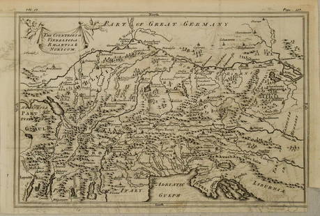
Sold20201750 c. Map of Eastern Alps Region in Ancient Times --Title: 1750 c. Map of Eastern Alps Region in Ancient Times -- The Countries of Vindelicia, Rhaethia & Noricum Cartographer: G Sale et al Year/Place: 1750 c., London Size: 7.8 X 11.8 in. Additional InfSee Sold Price
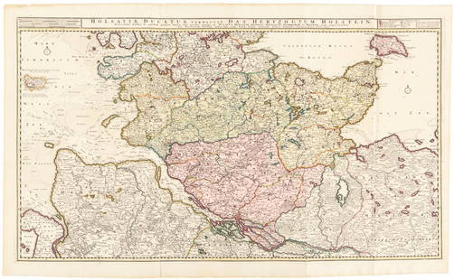
Sold2016Large map of Holstein, Germany 1720Heading: Author: Visscher, Nicolas Title: Holsatiae Ducatus Vernadule das Hertzogtum Holetein... Place Published: Amsterdam Publisher:Pieter Schenk, Jr. Date Published: c.1720 DescriptSee Sold Price
20231837 Prussia Map. Eastern Germany and now Poland by A. PerrotTitle: 1837 Prussia Map. Eastern Germany and now Poland by A. Perrot Date/Period: 1837 Materials: Copperplate engraved Size: 7 x 10 3/4” This is a map of Prussia (today Eastern Germany and PolanSee Sold Price
Sold201717TH C. MAP OF GERMANY TYPUS FRISIAE ORIENTALISDimensions: (Frame) H 19.5" x W 23.75" (Sight) H 15" x W 19.5" Condition: Holes to map. Discoloration and stains to paper. Wear to frame.See Sold Price
Sold2023Baedeker, Karl 1907 Lot of 65 Antique Maps. Eastern Alps. Germany Austria ItalyLithograph Maps Published 1907, Leipzig for "The Eastern Alps including The Bavarian Highlands, Tyrol, Salzburg, Upper and Lower Austria, Styria, Carinthia, and Carniola" by Karl Baedeker. Folds as isSee Sold Price
Sold2017MAP, C. 1750, INDIA & SOUTHEAST ASIA, ISAAK TIRIONFramed map of India an nearby countries, "Nieuwe Kaart van India over de Ganges of van Malakka, Siam, Cambodia, Chiampa, Kochinchina, Laos, Pegu, Ava" c. 1750 by Issak Tirion (Dutch, 1705-1765), handSee Sold Price
Sold2022Meissen model of a birdhouse, 18th c.Meissen model of a birdhouse, 18th c., c. 1750, Germany, polychrome enameled porcelain, modeled by Johann Gottlieb Ehder as an A-Frame birdhouse on brick pedestal, a colorful bird perched on an exteriSee Sold Price
Sold2022Bowen, Emanuel Collection of engraved maps, c.1750-65Bowen, Emanuel Collection of engraved maps, c.1750-65 including: A New and Accurate Map of China; A New and Accurate Map of the Empire of Japan; Turky in Asia, Arabia, etc.; A New and Accurate Map ofSee Sold Price
Sold2022Kleine Schatulle : Deutschland, um 1750Small box : Germany, c. 1750 A desk-shaped box with a pen tray, a compartment and two small drawers inside, the back and sides with applied watercolour drawings of couples and memento mori with a sayiSee Sold Price
Sold20211602 Ortelius Map of Eastern Belgium -- Namur NamenTitle: 1602 Ortelius Map of Eastern Belgium -- Namur Namen Cartographer: A Ortelius Year / Place: 1602, Antwerp Map Dimension (in.): 3 X 4.1 in. This is a lovely smaller map of eastern Belgium centereSee Sold Price
Sold20211720 c. Homann Map of Central Germany Near Fulda -- S.Title: 1720 c. Homann Map of Central Germany Near Fulda -- S. R. I. Principatus Fuldensis in Buchonia… Cartographer: J Homann Year / Place: 1720 c., Nurnberg Map Dimension (in.): 19.1 X 22.6 in. ThiSee Sold Price
Sold20201720 c. Homann Map of Central Germany's ThuringianTitle: 1720 c. Homann Map of Central Germany's Thuringian Forest Area -- Tabula Geographica in qua ... Principatus Gotha, Coburg et Altenburg Cartographer: J Homann Year/Place: 1720 c., Nurnberg DimenSee Sold Price
Sold2016N. C. Wyeth, Map of Discovery, Eastern & WesternTwo framed vintage prints / maps after N.C. Wyeth. "Map of Discovery, Eastern & Western Hemisphere". Signed and dated in the prints 1927. The images measure 15.5" x 17.75". Framed and matted under glaSee Sold Price
Sold202118th C Large Handcolored Mercator Map GermanyLarge beautifully handcolored map of Braunswyck and Meydburg after Gerard Mercator circa 1640, this being an 18th century restike.. Printed at Amsterdam. Measures 23 x 19". Fine, reinforced central veSee Sold Price
Sold2017ORNATE FIGURAL SIDE TABLE MANNER OF A. WEISWEILLERLouis XVI style hall table, 20th c., design in the manner of Adam Weisweiller (Germany, France, c. 1750-1810), ornately decorated with foliate and figural ormolu, the inset marble top with protrudingSee Sold Price
Sold2018EARLY BLUE UNPATTERNED PITKIN STYLE FLASK8"h., deep steel blue, non-lead bottle glass, elongated pear shaped body, double dipped with German half-post method, sheared lip, blowpipe pontil; America or Germany/Austria, c. 1750-1785, mint condiSee Sold Price
Sold2022c. 1788 French Map of the Eastern United StatesHistoric Maps c. 1788 Map, "Les Etats Unis de L'Amerique Septentrionale, Partie Orientale" (Eastern Part of the Northern United States of America) by M. (Rigobert) Bonne c. 1788 Map titled, "Les EtatsSee Sold Price
Sold20241640 c. Blaeu Map of Northeast Italy Centered on Urbino -- Ducato di UrbinoTitle: 1640 c. Blaeu Map of Northeast Italy Centered on Urbino -- Ducato di Urbino Cartographer: Blaeu [family] Year / Place: 1640 c., Amsterdam Map Dimension (in.): 15 X 19.6 in. This is a lovely douSee Sold Price
Sold20241890 c. Cram Map of Austria-Hungary [verso] Germany -- Austria [verso] GermanyTitle: 1890 c. Cram Map of Austria-Hungary [verso] Germany -- Austria [verso] Germany Cartographer: G Cram Year / Place: 1890 c., Chicago Map Dimension (in.): 8.2 X 11.2 in. This is a nice map of AustSee Sold Price
Sold2017Bellin: Antique Map of Eastern Siberia, 1750Map: Eastern Siberia Date Printed: 1750-60's Cartographer: Jacques Nicolas Bellin Material/Medium: Paper Size: 14" x 11" Condition: Excellent Copperplate engraving. Double page Map. From the Atlas DeSee Sold Price
Sold2021ROBERT DE VAUGONDY MAP OF SOUTH AMERICA, C. 1750Robert de Vaugondy (French, 1686-1766). "Amerique Meridionale" -1750, engraving with hand coloring. Approx. 20" x 24.75' (sheet)See Sold Price
2022Seutter, Matthaus (Germany, 1678-1757) Double Hemisphere World Map C. 1730Sight View  19-1/2" x 23", Overall View 22" x 25", Hand Colored "Quibus Addita, Pro Mutatione Horizontis Differentes Sphara Po Sitiones Earumque Convenientia Et RelaSee Sold Price
Sold2023Map of Germany and Sweden, &c. GENTLEMAN'S MAGAZINE. GENTS MAG 1741 oldTITLE/CONTENT OF MAP: 'Map of Germany and Sweden, &c' DATE PRINTED: 1741 IMAGE SIZE: Approx 19.5 x 11.0cm, 7.5 x 4.25 inches (Small) TYPE: Antique copperplate map CONDITION: Good; suitable for framingSee Sold Price
May 11Fichter KunsthandelP. SCHENK (*1693) after ZÜRNER (*1679), Map of Dresden and surroundings, before 1725, Copper en€200
May 14Hermann Historica GmbHA Greek silver phiale with lotus decoration, 6th - 5th century B.C.€2,600
May 22Curated AuctionsAN 18TH CENTURY GERMAN GOLD, JEWELLED AND AMETHYSTINE QUARTZ PUG DOG SNUFF BOX C. 1750£5,500
May 11Fichter KunsthandelM. SEUTTER (1678-1756), Dresden city map and panoramic view, 1730, Copper engraving€500
6 days LeftHunt and Peck Estate Services, Inc.1867 United States General Land Office "Rapport af Chefen fur Land-Kontoret i Furenta Saterna."$200
15 hrs LeftJay Anderson AuctionC 1910 OAK GERMAN GRANDFATHER CLOCK W/BRASS DIAL, 2 brass weights & pendulum signed (FMS with$50(1 bid)
May 14Fleischer's Auctions[NATIVE AMERICAN] Early 20th c. Clothing w/ Eastern Woodland Style Beadwork$100
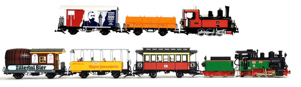
3 days LeftWinter Associates RAILROAD: Seven LGB European themed G Scale outdoor locomotives and train cars, German, 20th C.,$475(4 bids)


![1640 c. Blaeu Map of Northeast Italy Centered on Urbino -- Ducato di Urbino: Title: 1640 c. Blaeu Map of Northeast Italy Centered on Urbino -- Ducato di Urbino Cartographer: Blaeu [family] Year / Place: 1640 c., Amsterdam Map Dimension (in.): 15 X 19.6 in. This is a lovely dou](https://p1.liveauctioneers.com/5584/315423/169157874_1_x.jpg?height=310&quality=70&version=1705443824)
![1890 c. Cram Map of Austria-Hungary [verso] Germany -- Austria [verso] Germany: Title: 1890 c. Cram Map of Austria-Hungary [verso] Germany -- Austria [verso] Germany Cartographer: G Cram Year / Place: 1890 c., Chicago Map Dimension (in.): 8.2 X 11.2 in. This is a nice map of Aust](https://p1.liveauctioneers.com/5584/314989/168857560_1_x.jpg?height=310&quality=70&version=1704837726)


![[NATIVE AMERICAN] Early 20th c. Clothing w/ Eastern Woodland Style Beadwork (1 of 20)](https://p1.liveauctioneers.com/7226/322253/173251544_1_x.jpg?height=282&quality=70&version=1710004847)