Sold2019"Bartholemews Automobile Map Set of Great Britain,""Bartholemews Automobile Map Set of Great Britain," Nos. 1-23, now lacking #21-22, 21 Individual Leather Bound Folders, in a leather carrying case, Each- H.- 9 in., W.- 29 7/8 in.See Sold Price
Sold2024BARTHOLOMEWS QUARTER INCH AUTOMOBILE MAP OF GREAT BRITAIN VINTAGE ANTIQUEBARTHOLOMEWS QUARTER INCH AUTOMOBILE MAP OF GREAT BRITAIN VINTAGE ANTIQUESee Sold Price
Sold2023A Set of Raiders Of The Lost Ark Prop Dig Site Plans.(Paramount, 1981) A set of three printed reproductions of Great Britain cavern maps used as prop archaeological dig site maps in Raiders Of The Lost Ark. Measuring 13"x20", 13"x36", and the longest taSee Sold Price
Sold2023A 17th Century Map, Great Britain, Wenzel HollarA map surrounded by various panels showing historic events, center creased. Dimensions: Sight is 11 1/2" x 13 3/4", the frame 17 1/4" x 18 3/4" See Sold Price
Sold2022JOHN SPEED 17TH C. MAP, GREAT BRITAIN.John Speed map, ”The Kingdome of Great Britaine and Ireland,” engraved by J. Hondius, printed by Sudbury and Humble, London, 1610, with insets of London, Edinburgh, and the Orkney Islands,See Sold Price
Sold2024BOXED MECCANO DINKY 1938 AIRCRAFT 60 SET159. BOXED MECCANO DINKY 1938 AIRCRAFT 60 SET | Great Britain. | 9"l. box | (Excellent Condition) | $300 - $600See Sold Price
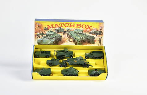
Sold2023Matchbox, G-5 Military Vehicles SetMatchbox, G-5 Military Vehicles Set, Great Britain, Druckguss, teilw. angelaufen, Z 2See Sold Price
Sold2021Marx Motorway, Victor Train + Chod Chod Train SetMarx Motorway, Victor Train + Chod Chod Train Set, Great Britain a.o., box C 1-2, C 1-2See Sold Price
Sold2021British Case Alaska Boundary Commission Appendix.[Americana] 18 sheets of maps, 2 index maps. Great Britain/Alaska Boundary Tribunal. “British case, Alaska boundary. Appendix Vol. III. -- : portfolio of maps accompanying International BoundarySee Sold Price
Sold2021FADEN'S MAP OF GREAT BRITAIN, 1795, FRAMEDFolding Pocket Map, "The Roads of Great Britain" by William Faden, Geographer to the King, 1795, with Supplement for the Roads of Scotland. Linen backed five by four fold, in black frame with gold linSee Sold Price
Sold2022Pair of pictorial airline poster maps of Great Britain. Inc...Pair of pictorial airline poster maps of Great Britain. Including: TAVENER. A Literary Map of Britain / Fly There by B.O.A.C. 1962. Poster airline map of Great Britain depicting numerous literary persSee Sold Price
Sold20211792 Elwe Map of Great Britain and Eire -- Les IslesTitle: 1792 Elwe Map of Great Britain and Eire -- Les Isles Britanniques qui contiennent les Royaumes d'Angleterre, Escosse, et Irlande distingues en leurs principales Provinces Cartographer: J Elwe YSee Sold Price
Sold2019New Map of Great BritainReserve Reduced! Title: New Map of Great Britain Publication Date: 1754 Cartographer: SENEX, JOHN/THOMAS BOWLES Publisher: T. BOWLES Size (inches): 36.5 x 25 Showing the extent of Public Surveys and oSee Sold Price
Sold2022Group of 14 Maps of Great Britain, Framed Celestial Map17th-19th century, engravings on laid or wove paper, all with hand colored highlights, comprising: John Speed, Darby Shire, London, circa 1630-1640, engraved by Peter Van Den Keere; John Owen & EmanueSee Sold Price
Sold2022Pinkerton french Map of Great Britain & Ireland 1806John Pinkerton (Scottish, 1758-1826): Map of Great Britain & Ireland 1806, copper hand colored engraving, from Abrege de la geographie moderne published in 1806 in Paris by Dentu Imprimeur.8" X 11 1/2See Sold Price
Sold2021H. Moll, circa 1736, Map of Great BritainConstructed in 2 panels, hand colored. Tears to edges at folds. Staining and mold to right side. 39-1/2" high x 25" wide. IMPORTANT: Before bidding, please read the terms and conditions. When you regiSee Sold Price
Sold2017Herman Moll A New Map of Great Britain 1717. TitlHerman Moll A New Map of Great Britain 1717. Title: 'A New Map of Great Britain According to the Newest and Most Exact Observations'. A large and very intricate map of the British isles with colouredSee Sold Price
Sold2023SET OF GREAT BRITAIN COLONIAL POSTAGE STAMPSSET OF BRITISH COLONIAL POSTAGE STAMPSSee Sold Price
Sold20201783 Cary Map of Great Britain and Ireland -- A Map ofTitle: 1783 Cary Map of Great Britain and Ireland -- A Map of Great Britain and Ireland with all the Adjacent Isles. Year/Place: 1783, London Cartographer: J Cary Size: 10.8 X 8.8 in. Additional InforSee Sold Price
Sold2020Map of Great Britain, Ireland, Russia PlusMap of Great Britain and Ireland PLUS Western Part of Russia and Denmark, Sweden and Norway on verso Two maps on one sheet. (back to back). Hand colored. [See photSee Sold Price
Sold2019Poirson & Tardieu l'Aine Map of Great Britain, 1803**Originally Listed At $150** Cartographer J.B. (Jean-Baptiste) Poirson (French, 1760-1831), Engraver: Jean Baptiste Pierre Tardieu l'Aine (French, 1746-1816). "Angleterre Ecosse et Irlande, on RoyaumSee Sold Price
Sold2018Bradshaw's Map of Great Britain Shewing the RailwaysTitle: Bradshaw's Map of Great Britain Shewing the Railways Publication Date: 1850 Cartographer: BRADSHAW & BLACKLOCK Publisher: BRADSHAW & BLACKLOCK Size: 22.5X16.5 "...completed and in progress withSee Sold Price
Sold2023AFTER NICOLAS SANSON (FRENCH, 1600-1667) MAP OF GREAT BRITAINAFTER NICOLAS SANSON (FRENCH, 1600-1667) MAP OF GREAT BRITAIN, hand-colored engraving on laid paper, engraving by Robert De Vaugondy. Unframed. Circa 1750. 21 3/4" x 31". Provenance: BSee Sold Price
Sold20211869 Mitchell Map of Great Britain, Ireland [verso]Title: 1869 Mitchell Map of Great Britain, Ireland [verso] Scandinavia-- XXX Great Britain and Ireland [verso] XXXI The Western Part of Russia with Denmark Sweden & Norway Cartographer: S Mithchell YeSee Sold Price
Jun 02Schilb Antiquarian Rare Books1897 History of British Empire England Scotland Canada James II MAPS India 6v$3(2 bids)
Jun 02Schilb Antiquarian Rare Books1871 Alfred the Great King of England MAP Battle of Ashdown Vikings Thom Hughes$125(3 bids)
13 hrs LeftRichard L. Edwards Auctioneering17-World Coins (Japan/Korea/Southeast Asia/Singapore/United Arab Emirates/Israel/Kenya & Great$1
4 days LeftBK Auctions2020 Proof US & Great Britain Mayflower Coin Set NGC PF70 Ultra Cameo Costello Signed$1
BonhamsA 50 piece silver coin / medallion set, titled 'The Mountbatten Medallic History of Great Britai...£1,000(9 bids)
6 hrs LeftDOYLE Auctioneers & AppraisersRoyal Interest: Set of Twelve French Empire Silver-Gilt Chargers with the Royal Arms of Hanover$4,000(1 bid)
Jun 08Early American History Auctions1753 Map of the County of Lancaster Divided into its Hundreds, by Royal Mapmaker Emanuel Bowen$280
9 hrs LeftRapid Estate Liquidators and Auction GalleryGainsborough by Spode Copeland Great Britain Dinnerset$150
May 29Elmwood'sAN ANTIQUE QUEEN CAROLINE OF GREAT BRITAIN (1683-1737) PORTRAIT MINIATURE PENDANT in yellow gold,£480
Chiswick AuctionsTRISTAN DA CUNHA, 2015 'PORTRAITS OF ELIZABETH II' GOLD PROOF SOVEREIGN 5-COIN SET.£1,700(2 bids)
6 hrs LeftDOYLE Auctioneers & AppraisersRoyal Interest: Pair of French Empire Silver-Gilt Verrieres with the Royal Arms of Hanover Biennais,$3,500(1 bid)
May 29Cedarburg Auction & Appraisals LLCSet of Four Maps Showing All of Spain and Portugal$375(2 bids)


![British Case Alaska Boundary Commission Appendix.: [Americana] 18 sheets of maps, 2 index maps. Great Britain/Alaska Boundary Tribunal. “British case, Alaska boundary. Appendix Vol. III. -- : portfolio of maps accompanying International Boundary](https://p1.liveauctioneers.com/179/209052/106367317_1_x.jpg?height=310&quality=70&version=1624651037)


![1869 Mitchell Map of Great Britain, Ireland [verso]: Title: 1869 Mitchell Map of Great Britain, Ireland [verso] Scandinavia-- XXX Great Britain and Ireland [verso] XXXI The Western Part of Russia with Denmark Sweden & Norway Cartographer: S Mithchell Ye](https://p1.liveauctioneers.com/5584/208823/106313420_1_x.jpg?height=310&quality=70&version=1625000702)


