Sold20211631 Latin Hand Colored Map of Asia1631 Latin Hand Colored Map of Asia framed Framed Measures 18 1/4 x 23 1/2See Sold Price
Sold2024Abraham Ortelius Indiae Orientalis 1580 MapAbraham Ortelius (Belgian, 1527-1598). Indiae Orientalis, Insularumque Adiacientium Typus, circa 1580. Hand colored engraved map of India, China, southeast Asia. Text page, India, in Latin on verso. 1See Sold Price
Sold2022THREE HAND-COLORED MAPS OF ASIATHREE HAND-COLORED MAPS OF ASIA1) “Asia”, from a miniature Ortelius atlas, Brescia, after 1598. 3.75” x 5” sight. Framed 9” x 10.5”.2) “A New Map of Asia̶See Sold Price
Sold2022LARGE HAND-COLORED MAP OF ASIA 20” x 24” sight. Framed 29.5” x 33.5”.LARGE HAND-COLORED MAP OF ASIA“Asia, Concinnata Secundum Observationes Academia Regalis Scientiarum et nonnullas alias, et juxta annotations recentissimas per G. de L'Isle”, Tobias ConradSee Sold Price
Sold2021Large hand colored map of Asia, 1875Large vintage map of Asia in the not-often seen hand-colored version. Most likely drawn by A. K. Johnston, and appearing the very scarce Jones and Hamilton Atlas of the World Illustrated, published 18See Sold Price
Sold2018EARLY HANDCOLORED MAP OF ASIA, FROM GROUP WE AREEARLY HANDCOLORED MAP OF ASIA, FROM GROUP WE ARE SELLING. CAN'T SEE A DATE, FRAMED AND MATTED. MEASURES 20" X 23". NICE CONDITION, LOOKS LIKE SMALL TEAR IN UPPER LEFT CORNER BY THE MATTING.See Sold Price
Sold2020(2) HANDCOLORED MAPS OF ASIABurma, Siam, French Indo-China and Straits Settlements and Physical Map of Asia . Dimensions: H 9.75" x W 12.75" Condition: Folding, toning and a tear to the middle of the Map of Asia.See Sold Price
Sold2020Gerardus Mercator Map of Asia 1613Gerardus Mercator (1512-1594), "Asia ex magna orbis terre descriptione Gerardi Mercatoris desumpta studio et industria G.M. Iunioris," Amsterdam, ca. 1613. Hand colored map of Asia. Dimensions: Sight;See Sold Price
Sold2020Willem Blaeu Map of Guinea ca. 1631Willem Janszoon Blaeu (1571-1638), "Guinea," Amsterdam, ca. 1631. A hand colored map of the Gulf of Guinea region of Africa, including what is now Guinea, Sierra Leone, Liberia, Cote d'Ivoire, Ghana,See Sold Price
Sold2023Map of Asia toward the end of the 18th century – PerthesFascinating hand-colored map depicts Asia at the end of the 18th century. The British had established themselves in India and the Chinese Empire was under Manchu control. Also depicts Southeast Asia iSee Sold Price
Sold2021LEVASSEUR: HAND-COLORED ENGRAVED MAP OF ASIAHand-Colored Engraved Map of Asia, Published in the 'Atlas Universel Illustre' in Paris in 1850 by Levasseur. Printed by Lemercier. The verso of the frame mounted with a certificate of authenticity. PSee Sold Price
Sold2015Tabula Indiae Orientalis byFrederick de Wit Amsterdam, 1662, de Wit's attractive hand-colored map of Southeast Asia, engraved by Joannas Lhulier, this map served as a prototype for Speed's map of the East Indies, cartouche withSee Sold Price
Sold20151764 JACQUES NICHOLAS BELLIN MAP ROYAUMES DE SIAMA 1764 engraved and hand-colored map depicting South Asia, titled, "Carte des Royaumes de Siam, de Tunquin, Pegu, Ava Aracan, &c.", published by Jacques Nicolas Bellin (1703-1772, France) on laid, watSee Sold Price
Sold2021[LOW COUNTRIES]. ORTELIUS, Abraham. Descriptio[LOW COUNTRIES]. ORTELIUS, Abraham. Descriptio Germaniae Inferioris. Antwerp, 1572. Text in Latin on verso. Hand–colored engraved map (17 ½ x 21 ½”), detailing the Netherlands, BSee Sold Price
Sold2023"Africa" by John Luffman & "Asia" Antique Handcolored Maps"Africa" by John Luffman & "Asia" Antique Handcolored Maps.See Sold Price
Sold202218th & 19th C. MAPS OF ASIA (3 MAPS)Includes: 2 maps by John Tallis & Co. London / New York, ca. 1850, both matted and framed, including: (1) MAP OF ASIA. Hand colored engraved map. 5 hand colored vignettes. H. 10.25", W. 12.75"; (2) MASee Sold Price
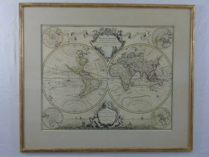
Sold2016Large Framed World Map w/ Latin InscriptionsLarge Framed World Map w/ Latin Inscriptions. Hand colored. Professionally framed and matted. Titled Mappe Monde. Measures 28 by 33 inches.See Sold Price
Sold2020Nicolas Sanson Map of AsiaNicolas Sanson (1600-1667) "L'Asie divisee en ses Principales Regions, et ou se peuvent voir l'estendue, Des Empires, Monarchies, Royaumes, et Estats," Paris: Jaillot, ca. 1719. Hand colored map of AsSee Sold Price
Sold2017Framed Italian Engraved Hand Colored Map of theFramed Italian Engraved Hand Colored Map of the Adriatic Sea, with Latin and Italian writing; focusing on three islands: San Domino, Santo Niccola, and La Caprara; written in Latin at the top "InsulaeSee Sold Price
Sold2023ANTIQUE 18TH C HAND COLORED MAP OF OTTOMAN EMPIREAn antique early 18th-century hand-colored engraved map representing the Ottoman Empire. Published in Nuremberg, Germany, 1720. Titled Imperium Turcicum, technical information in Latin in the lower leSee Sold Price
Sold201518th Century Hand Colored Map, Bohemia,"Royaume de Bohemes", approx 10" x 15".....The Kingdom of Bohemia (in Czech: České království; in German: Königreich Böhmen; in Latin: Regnum Bohemiae) is a kingdom located in the region ofSee Sold Price
Sold2021J. Hinton 1762 An Improved Map of AsiaHand colored map on wove paper "An improved map of Asia : with all the discoveries that have been made to the present time" by John D. Hinton (d.1781) published by the Universal Magazine, J. Hinton, NSee Sold Price
Sold2015A New Map of the East IndiesTaken from M. de Fer's Map of Asia by Edward Wells (1667-1727), circa 1700, hand-colored map was part of a set of 22 maps dedicated to William, Duke of Gloucester, title cartouche includes the Royal CSee Sold Price
Sold2018Map of Asia by Seutter, 1740Title/Content of Map: Asia by Seutter Date Printed: c1740 Cartographer: Matthaus Seutter Material/Medium: Paper Size: 23" x 19" Provenance: New York Original hand colored copperplate engraved. PublishSee Sold Price
5 days LeftHunt and Peck Estate Services, Inc.Abraham Ortelius Natoliae, Quae Olim Asia Minor, Nova Descriptio$100
9 hrs LeftTrillium Antique Prints & Rare BooksBraun & Hogenberg, pub. 1575 - View of Cusco, Peru and Mexico$425(4 bids)
9 hrs LeftTrillium Antique Prints & Rare BooksBraun & Hogenberg, pub. 1575 - View of Jerusalem, Israel$100(1 bid)
9 hrs LeftTrillium Antique Prints & Rare BooksBraun & Hogenberg, pub. 1575 - View of Rotterdam, Netherlands$100(1 bid)
9 hrs LeftTrillium Antique Prints & Rare BooksBraun & Hogenberg, pub. 1575 - View of Ghent, Belgium$100(1 bid)
9 hrs LeftTrillium Antique Prints & Rare BooksBraun & Hogenberg, pub. 1575 - View of Innsbruck, Germany$100(1 bid)
9 hrs LeftTrillium Antique Prints & Rare BooksBraun & Hogenberg, pub. 1575 - View of Luxembourg$100(1 bid)
May 11Trillium Antique Prints & Rare BooksBraun & Hogenberg, pub. 1575 - View of Basel, Switzerland$100
May 11Trillium Antique Prints & Rare BooksBraun & Hogenberg, pub. 1575 - View of Marseille, France$100
May 11Trillium Antique Prints & Rare BooksBraun & Hogenberg, pub. 1575 - View of Haarlem, Netherlands$100
May 11Trillium Antique Prints & Rare BooksBraun & Hogenberg, pub. 1575 - View of Limbourg, Belgium$100
May 11Trillium Antique Prints & Rare BooksBraun & Hogenberg, pub. 1575 - Coats of arms of Hannonia, Hennegau in Belgium$100
May 18Blackstone Valley Auctions & Estates LLCRevolutionary Era War Map of the Attack on Ft. Moultrie.$100


![[LOW COUNTRIES]. ORTELIUS, Abraham. Descriptio: [LOW COUNTRIES]. ORTELIUS, Abraham. Descriptio Germaniae Inferioris. Antwerp, 1572. Text in Latin on verso. Hand–colored engraved map (17 ½ x 21 ½”), detailing the Netherlands, B](https://p1.liveauctioneers.com/928/222494/114617134_1_x.jpg?height=310&quality=70&version=1634568084)