Sold2018Mallet: Antique Celestial Map Southern Night Sky, 1683TITLE OF THE MAP: 'Planisphere des Constellations Meridionalles' SOUTHERN NIGHT SKY. Planisphere Constellations Meridionalles. DATE PRINTED: 1683 IMAGE SIZE: Approx Overall page size 13 x 21cm approxiSee Sold Price
Sold2018Mallet: Antique Celestial Map Southern Night Sky 1683TITLE OF MAP (NOT PRINTED ON THE PAGE): '[Planisphere des Constellations Meridionales comme elles sont veuës de la Terre]' SOUTHERN NIGHT SKY. Constellations Meridionales. Man in moon. DATE PRINTED:See Sold Price
Sold2018Mallet: Antique Celestial Map Northern Night Sky, 1683TITLE OF MAP (NOT PRINTED ON THE PAGE):'[Planisphere des Constellations Septentrionales comme elles sont veuës de la Terre]' NORTHERN NIGHT SKY Constellations Septentrionalles. Man in moon. DATE PRINSee Sold Price
Sold20221719 Mallet Map of the Northern Constallations -- Fig. 34Title: 1719 Mallet Map of the Northern Constallations -- Fig. 34 Cartographer: A Manesson-Mallet Year / Place: 1719, Paris Map Dimension (in.): 5.8 X 4.1 in. This is a lovely smaller celestial chart oSee Sold Price
Sold2019MAP - Southern US. Van der AaColonial Southern United States. Pieter van der Aa, La Floride, Suivant les Nouvelles Observations de Messrs. de l'Academie Royale des Sciences, Etc., 1713 (circa). Black & White. This handsome map ofSee Sold Price
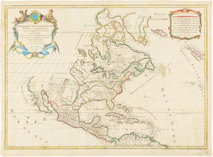
Sold2020Jacques Chiquet North America Map 1719 CaliforniaJacques Chiquet (1673-1721), "L'Amerique Septentrionale qui fait partie des Indes Occidentales," Paris, 1719. This excellent hand colored map of North America includes a depiction of California as anSee Sold Price
Sold2017G.C. Eimmart, 18th c. celestial mapG.C. Eimmart, 18th c. celestial map, Georg Christoph Eimmart (German, 1638-1705), "Planetsphaerium Caeleste", c. 1700, a celestial planisphere featuring the constellations of the northern and southernSee Sold Price
Sold2016Carte Contenant le Royaume du Mexique la Floridie, 1719Map: Carte Contenant le Royaume du Mexique et la Floridie Cartographer: H. Chatelain Publishing: 1719 Size: 20.6 x 15.9 inches This map is a derivative of Delisle's landmark map of the southern part oSee Sold Price
Sold2015Map of North America 1719Heading: (North America) Author: Sanson, Nicolas/ Hubert Jaillot Title: Amerique Septentrionale divisée en ses Principales Parties, ou sont distingués les uns des autres les Estats suivant quils appSee Sold Price
Sold20241719 BIBLE in DUTCH ILLUSTRATED w/ MAPS antique MASSIVE FOLIO BIBLIAantbooks1 BIBLIA, DAT IS DE GANTSCHE H. SCHRIFTURE, vervattende alle de canonijcke boecken des ouden en des nieuwen testaments (...). Laft Der Hoogha Mgh Heeren Dordrecht, Pieter Keur; 1719 IllustrateSee Sold Price
Sold2016Carte du Canada ou de la Nouvelle France, 1719Map: Carte du Canada ou de la Nouvelle France, & des Decouvertes qui y Ont Ete Faites, Dressee sur les Observations les Plus Nouvelles, & sur Divers Memoires tant Manuscrits qu'Imprimez Cartographer:See Sold Price
Sold20241719 Map of Colonial era North America, by Sanson - JaillotTitle: 1719 Map of Colonial era North America, by Sanson - Jaillot Date/Period: 1719 Materials: Copperplate engraved Size: 25 1/2 x 18” This map is a rare and valuable map of history, showing NoSee Sold Price
Sold2017Senex: Map of Virginia & Maryland, 1719Map: 1719 Senex Map of Virginia and Maryland -- A New Map of Virginia Mary:Land and the Improved Parts of Pennsylvania & New Jersey Cartographer: J Senex Year / Place: 1719, London Map Dimensions: 19See Sold Price
Sold2022Railroad Lock Keys (18), multiple Iowa RR LinesID Marks: N&NRR (Newton & Northwestern RR); CR&ICRY (Cedar Rapids &Iowa City RY); DM&CI (Des Moines & Central Iowa); FDDM&S (Fort Dodge Des Moines & Southern); DEMCRYCO (Des Moines City RY); DMURR (DeSee Sold Price
Sold2018South East Asia.- Ortelius (Abraham) Indiae OrientalisSouth East Asia.- Ortelius (Abraham) Indiae Orientalis Insularumque Adiacientium Typus, map of southern Asia from India across to Java and New Guinea, and including China and Japan to the north, withSee Sold Price
Sold2022Phoenix-eared "mallet" vase, Longquan, Southern Song dynasty (1127 - 1279)A vase made of celadon-glazed ceramic with a greenish-blue or sea-green moulded in the shape of a (mallet bottle with phoenix ears), which together with the handle-less shape was a recurring model inSee Sold Price
Sold2020Des Barres Map of NY Harbor*** START PRICE IS THE RESERVE *** [America] DES BARRES, Joseph Frederick Wallet (1729-1824). A Chart of New York Harbour with the Soundings Views of Land Marks and Nautical directions for the Use ofSee Sold Price
Sold2022c 1780 Map of The World Liverpool Creamware BowlGlass and Porcelain "The WORLD in PLANISPHERE." World Map Transfer Large 13.5" Historic Liverpool Creamware Titled Bowl c. 1780-1800 Revolutionary War Period to Federal Period, Historical Liverpool CrSee Sold Price
Sold2021(CELESTIAL.) Ignace Gaston Pardies. [Plate 6 -(CELESTIAL.) Ignace Gaston Pardies. [Plate 6 - Constellations of the Southern Sky]. Hand-colored double-page engraved celestial chart with flanking descriptive columns in Latin and French. 19x28¼See Sold Price
Sold2024Map of Texas and Indian TerritoryMap of Texas and Indian Territory West Central States and States of the Plains - Southern Division. Color Map. Publisher Harper Brothers Dated: 1888 Dimensions: 12 x 9" ConSee Sold Price
Sold2017FRAMED WORLD MAP BY HERMAN MOLL, 1719'A New & Correct Map of the Whole World, by Herman Moll, Geographer, 1719.' Hand tinted and framed. Frame size: 73 x 124 cm (28 3/4 x 48 3/4 in.)See Sold Price
Sold2017Moll - Correct Map of the Whole World, 1719Herman Moll (1654?-1732), cartographer and publisher A New & Correct Map of the Whole World Shewing y.e Situation of its Principal Parts. Viz the Oceans, Kingdoms, Rivers, Capes, Ports, Mountains, WooSee Sold Price
Sold2022DES BARRES, JOSEPH FREDERICK WALLET The North East Shore of the Gulph of Mexico. London: circa 1780.DES BARRES, JOSEPH FREDERICK WALLET The North East Shore of the Gulph of Mexico. London: circa 1780. A very large hand-colored engraved map on four joined sheets. Overall 30 x 84 inches (76 x 214 cm).See Sold Price
2 days LeftSchilb Antiquarian Rare Books1848 Emory Military Reconnaissance 1ed California MAP Indians Texas New Mexico$56(7 bids)
Jul 06Case Antiques, Inc. Auctions & Appraisals5 TVA Map Books incl. Tennessee & New York c. 1935-1950$250
1 day LeftTrillium Antique Prints & Rare BooksKohler & Weigel - Celestial Chart with Draco, Ursa Major & Minor, Cepheus, Cassiopea, Cygnus, & More$75
1 day LeftTrillium Antique Prints & Rare BooksBrown's New Illustrations of Zoology - Volume with 50 Originally Hand-colored Engravings$500
Jun 30JM Hobby Supply and Railroad Artifact AuctionsSouthern Pacific RR Daylight Scheme N Scale 18 Unit Psgr Train Set-Con Cor Models$90(5 bids)
Will Sullivan Auction Co.U.S. Circa WWII Navy Pilots Folding Survival Knife W/ OD Canvas Pouch - Colonial$220(21 bids)
2 days LeftSchilb Antiquarian Rare Books1977 JRR Tolkien 1st ed Silmarillion Lord of the Rings Middle Earth + MAP$155(7 bids)
Jun 29Thomaston Place Auction GalleriesRARE PRE-UNION CIRCA 1840 WESTERN APACHE OR SOUTHERN UTE WAR SHIRT, MOUNTAIN LION HIDE$6,000
2 days LeftSchilb Antiquarian Rare Books1890 Livingstone 1ed In Darkest Africa Henry Stanley Emin Pasha Expedition MAP$145(8 bids)
2 days LeftSchilb Antiquarian Rare Books1870 BEAUTIFUL Life of Jesus Christ Fleetwood Bible ART Miracles Jerusalem Map$150(7 bids)


![Mallet: Antique Celestial Map Southern Night Sky 1683: TITLE OF MAP (NOT PRINTED ON THE PAGE): '[Planisphere des Constellations Meridionales comme elles sont veuës de la Terre]' SOUTHERN NIGHT SKY. Constellations Meridionales. Man in moon. DATE PRINTED:](https://p1.liveauctioneers.com/5584/116403/59827344_1_x.jpg?height=310&quality=70&version=1518568442)
![Mallet: Antique Celestial Map Northern Night Sky, 1683: TITLE OF MAP (NOT PRINTED ON THE PAGE):'[Planisphere des Constellations Septentrionales comme elles sont veuës de la Terre]' NORTHERN NIGHT SKY Constellations Septentrionalles. Man in moon. DATE PRIN](https://p1.liveauctioneers.com/5584/116403/59827346_1_x.jpg?height=310&quality=70&version=1518568442)


![Des Barres Map of NY Harbor: *** START PRICE IS THE RESERVE *** [America] DES BARRES, Joseph Frederick Wallet (1729-1824). A Chart of New York Harbour with the Soundings Views of Land Marks and Nautical directions for the Use of](https://p1.liveauctioneers.com/1968/163248/82424572_1_x.jpg?height=310&quality=70&version=1583340284)


![(CELESTIAL.) Ignace Gaston Pardies. [Plate 6 -: (CELESTIAL.) Ignace Gaston Pardies. [Plate 6 - Constellations of the Southern Sky]. Hand-colored double-page engraved celestial chart with flanking descriptive columns in Latin and French. 19x28¼](https://p1.liveauctioneers.com/199/226915/117191944_1_x.jpg?height=310&quality=70&version=1637249113)


