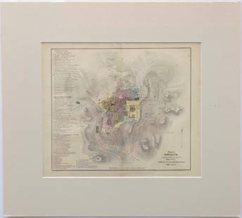
Sold2017I.H. Coccejo / Weigel: Map of Jerusalem, 1720Map: Jerusalem, "Ierusalem aus den Schrifften Iosephi" Cartographer: I.H. Coccejo. / Weigel Place & Date: Nuremberg / 1720 Size: 16 5/8" x 13" Condition: original color; overall age toning and minor sSee Sold Price
Sold2015Maps, Christoph Weigel [Group of 6][Group of 6 maps by Christoph Weigel, hand-color, all measuring approx. 15" x 12", all 18th c.] **** 1: Ducatus Carnioliae. 3" cut to lower left margin, 1" closed tear to lower margin, vertical creaseSee Sold Price
Sold2018Weigel: Antique Map of Italy, 1720Title/Content of Map: Italy by Weigel Date Printed: c1720 Cartographer: C. Weigel Material/Medium: Paper Size: 14" x 17 1/2" Hand colored copperplate engraved. Published in Nuremberg. Please note thatSee Sold Price
Sold2018Weigel: Antique Map of Sardinia, 1720Title/Content of Map: Regni Sardiniae Descriptio Cartographer: Weigel Place & Date: Nuremberg / 1720s Size: 12 1/2" x 15 3/4" Condition: wash color; very light overall age toning A beautifully designeSee Sold Price
Sold2022(MISSISSIPPI BUBBLE.) Christoph Weigel. Novissima Tabula Regionis Ludovicianae Gallice Dictae La(MISSISSIPPI BUBBLE.) Christoph Weigel. Novissima Tabula Regionis Ludovicianae Gallice Dictae La Louisiane. Double-page engraved map of French Louisiana with a pair of investment schemers pictured atSee Sold Price
Sold2022(AMERICAS.) Christoph Weigel. Novi Orbis Sive Totius Americae cum Adiacentibus Insulis.(AMERICAS.) Christoph Weigel. Novi Orbis Sive Totius Americae cum Adiacentibus Insulis. Engraved map of the western hemisphere showing California as an island and a decorative figural title cartouche.See Sold Price
Sold2017Weigel: Antique Map of Israelite Exodus Encampment 1720Map: Castra metatio oder Zeichnung der Lager-Ordnung, nach welcher die XII. Stämme des Volks Gottes Cartographer: Weigel Place & Date: Nuremberg / 1720s Size: 16 5/8" x 13" Condition: original color;See Sold Price
Sold2019Map of Moscovy in early 18th centuryHeading: Author: Weigel, Johann Christoph Title: Imperium Moscoviae Place Published: Nuremberg Publisher: Date Published: c.1720 Description: Copper-engraved map, hand-coloSee Sold Price
Sold2022(POLAR.) Christoph Weigel. Facies Poli Arctici. [and] Facies Poli Antarctici.(POLAR.) Christoph Weigel. Facies Poli Arctici. [and] Facies Poli Antarctici. Together two double-page engraved charts of the globe's northern and southern hemispheres. Approximately 13½x15 incheSee Sold Price
Sold2019MAP - Jerusalem, Holy Land. DanckertsJerusalem, Holy Land. Cornelius Danckerts, De Stadt Ierusalem, 1718 (published). Hand Color. Great bird's-eye plan of the ancient holy city flanked by engravings of religious icons. At the bottom areSee Sold Price
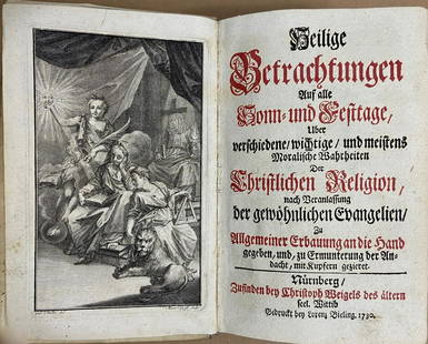
Sold2021Compilation of Devotional Texts, Christoph Weigel, 1730A compendium of devotional texts in two parts for Sundays and religious feasts, illustrated with 86 copperplate engravings by Johann Christoph Weigel the Elder (1654-1725), also known as Christoph WeiSee Sold Price
Sold2022Christoph Weigel, Discus ChronologicusDiscus Chronologicus,chronological volvelle table charting Europe's rulers with separately coloured rings for each country, from the birth of Christ up to 1800, with names printed to c.1760 DimensionsSee Sold Price
Sold2022(GERMAN EMPIRE.) Christoph Weigel. Discus Cronologicus Omnium S.R.I. Electorum.(GERMAN EMPIRE.) Christoph Weigel. Discus Cronologicus Omnium S.R.I. Electorum. Engraved circular broadside charting a historical timeline of monarchs of the German Empire from 1200 to 1716 with a movSee Sold Price
Sold2021Wright, Paul 1782 Holy Land Map. Jerusalem"A Correct Plan of the Antient City of Jerusalem" by Thomas Conder. Folio Copper Plate Published 1782, London for "The Complete British Family Bible…" by Paul Wright. Paper Size: 14.5 x 9.5 inch (37See Sold Price
Sold2023Wright, Paul 1782 Folio Holy Land Map. Jerusalem City"A Correct Map of the Antient City of Jersusalem and Parts Adjacent" Folio Copper Engraved Map Published 1782, London for "The Complete British Family Bible…" by Paul Wright. Drawn and Engraved by TSee Sold Price
Sold20221850 Survey of Holy Land MAPS Jerusalem Bethlehem Canaan Bible Nativity Israel1850 Survey of Holy Land MAPS Jerusalem Bethlehem Canaan Bible Nativity Israel J.T. Bannisters “Survey of the Holy Land” is a rare, mid-19th-century history of Israel and Palestine. In thiSee Sold Price
Sold2024Nicholas de Fer, Map of California of 1705Nicholas de Fer (1646-1720) Map of California of 1705 (Cette carte de Californie et du Nouveau Mexique, 1705); together with two other California related framed ephemera.Assumed second state (1705) ofSee Sold Price
Sold2021H. Moll C. 1730 Map of AsiaDESCRIPTION: H. Moll c. 1720 Map of Asia. Dedicated to the Right Honorable William, Lord Cowper, Lord High Chancellor of Great Britain. Hand colored, completed in three parts. MEASUREMENTS: 40 " wideSee Sold Price
Sold2017Map of Jerusalem and Its Ruins, 1872Map: Jerusalem and Its Ruins Maker: Redding & Co Date: 1872 Size: Folio, 15.3 inches high x 19.75 inches wide Detailed plan of ancient biblical sites in the Holy City. Fine, Large Plan of Jerusalem PlSee Sold Price
Sold2016Modern Jerusalem, 1858Map: Jerusalem before the Roman Destruction Publishing: Sarony & Major, 1858 Medium: Hand colored lithograph Size: 13.5 x 15 inches Napoleon Sarony (1821-1896) was an American lithographer and a highlSee Sold Price
Sold2017Map, "Cataloniae" Johann Baptist Homann, c.1720Johann Baptist Homann (German, b.1664-1724). 1720 map of Catalonia region of Spain by cartographer Johann Baptist Homann. Place / Date: Nuremberg, c.1720. Antiquarian Map, "Principatus Cataloniae necSee Sold Price
Sold201818TH CEN GERMAN AND LATIN BIBLICAL ENGRAVINGSCount: 42 - Biblical Engravings c.18th Century – appear in Latin and German, illustrations with text above and below, with varying scenes, by the German artist Christoph Weigel. Dimensions: H 5" x WSee Sold Price
Sold2021Jerusalem & Palestine 1889Title/Content of Map: Jerusalem & Palestine 1889 Date Printed: 1889 Material/Medium: Paper Size: approx 11x14 inches Mast, Crowell & Kirkpatrick, Peerless Atlas of the World Reserve: $30.00 Shipping:See Sold Price
May 25Trillium Antique Prints & Rare BooksKohler - Timewheel with Volvule of the Rulers in the German Empire (Discus Cronologicus Omnium$75
May 25Trillium Antique Prints & Rare BooksKohler - Timewheel with Volvule of the Kings and Dukes of Italy (Discus Chronologicus Regum$75
Jun 23Schilb Antiquarian Rare Books1870 BEAUTIFUL Life of Jesus Christ Fleetwood Bible ART Miracles Jerusalem Map$34(2 bids)
Jun 23Schilb Antiquarian Rare Books1790 Life of Jesus Christ Fleetwood Bible ART Miracles Jerusalem MAP Holy Land$42(2 bids)
Jun 07Freeman's | HindmanHOMANN, Johann Baptist. Amplissimae Regionis Mississipi Seu Provinciae Ludovicianae. Nuremburg, [ca$400(1 bid)
5 days LeftJasper52ASIA. Political. Shows West Bank under Jordanian occupation.BARTHOLOMEW 1952 map$15
May 30Forum AuctionsJudaica.- Israeli Defense Force (Educational Department) [Plan of The Temple Mount, or Haram£400
5 days LeftConcept Art GalleryLithographs of Marc Chagall II complete with 11 lithos and DJ$300(1 bid)
1 day LeftBlackstone Valley Auctions & Estates LLCRevolutionary Era War Map of the Attack on Ft. Moultrie.$275(3 bids)
May 29Cedarburg Auction & Appraisals LLCSet of Four Maps Showing All of Spain and Portugal$175(2 bids)


![Maps, Christoph Weigel [Group of 6]: [Group of 6 maps by Christoph Weigel, hand-color, all measuring approx. 15" x 12", all 18th c.] **** 1: Ducatus Carnioliae. 3" cut to lower left margin, 1" closed tear to lower margin, vertical crease](https://p1.liveauctioneers.com/3532/79779/41533565_1_x.jpg?height=310&quality=70&version=1444167022)


![(POLAR.) Christoph Weigel. Facies Poli Arctici. [and] Facies Poli Antarctici.: (POLAR.) Christoph Weigel. Facies Poli Arctici. [and] Facies Poli Antarctici. Together two double-page engraved charts of the globe's northern and southern hemispheres. Approximately 13½x15 inche](https://p1.liveauctioneers.com/199/251723/130782408_1_x.jpg?height=310&quality=70&version=1655133895)