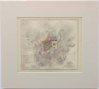
Sold2017I.H. Coccejo / Weigel: Map of Jerusalem, 1720Map: Jerusalem, "Ierusalem aus den Schrifften Iosephi" Cartographer: I.H. Coccejo. / Weigel Place & Date: Nuremberg / 1720 Size: 16 5/8" x 13" Condition: original color; overall age toning and minor sSee Sold Price
Sold2018Weigel: Antique Map of Italy, 1720Title/Content of Map: Italy by Weigel Date Printed: c1720 Cartographer: C. Weigel Material/Medium: Paper Size: 14" x 17 1/2" Hand colored copperplate engraved. Published in Nuremberg. Please note thatSee Sold Price
Sold2018Weigel: Antique Map of Sardinia, 1720Title/Content of Map: Regni Sardiniae Descriptio Cartographer: Weigel Place & Date: Nuremberg / 1720s Size: 12 1/2" x 15 3/4" Condition: wash color; very light overall age toning A beautifully designeSee Sold Price
Sold2017Weigel: Antique Map of Israelite Exodus Encampment 1720Map: Castra metatio oder Zeichnung der Lager-Ordnung, nach welcher die XII. Stämme des Volks Gottes Cartographer: Weigel Place & Date: Nuremberg / 1720s Size: 16 5/8" x 13" Condition: original color;See Sold Price
Sold2019Map of Moscovy in early 18th centuryHeading: Author: Weigel, Johann Christoph Title: Imperium Moscoviae Place Published: Nuremberg Publisher: Date Published: c.1720 Description: Copper-engraved map, hand-coloSee Sold Price
Sold20211734 Weigel Map of French and British Pocessions inTitle: 1734 Weigel Map of French and British Pocessions in America -- Novissima Tabula Regionis Ludovicianae Gallice dicta la Louisiane… Cartographer: C Weigel Year / Place: 1734, Nurnberg Map DimenSee Sold Price
Sold2024Weigel map of Americas Calif. an islandHeading: (America) Author: Weigel, Christopher Title: Novi Orbis sive Totius Americae cum Adiacentibus Insulis Nova Exhibitio Place Published: Nuremberg Publisher: Date Published: [1725] <See Sold Price
Sold2016Decprative world map 1720Heading: Author: Homann, Johann Baptiste Title: Planiglobii Terrestris cum Utroq Hemisphaerio Caelesti Generalis Exhibitio Place Published: Nuremberg Publisher: Date Published: c.1720See Sold Price
Sold2019MAP - Jerusalem, Holy Land. DanckertsJerusalem, Holy Land. Cornelius Danckerts, De Stadt Ierusalem, 1718 (published). Hand Color. Great bird's-eye plan of the ancient holy city flanked by engravings of religious icons. At the bottom areSee Sold Price
Sold2021Wright, Paul 1782 Holy Land Map. Jerusalem"A Correct Plan of the Antient City of Jerusalem" by Thomas Conder. Folio Copper Plate Published 1782, London for "The Complete British Family Bible…" by Paul Wright. Paper Size: 14.5 x 9.5 inch (37See Sold Price
Sold2023Wright, Paul 1782 Folio Holy Land Map. Jerusalem City"A Correct Map of the Antient City of Jersusalem and Parts Adjacent" Folio Copper Engraved Map Published 1782, London for "The Complete British Family Bible…" by Paul Wright. Drawn and Engraved by TSee Sold Price
Sold20221850 Survey of Holy Land MAPS Jerusalem Bethlehem Canaan Bible Nativity Israel1850 Survey of Holy Land MAPS Jerusalem Bethlehem Canaan Bible Nativity Israel J.T. Bannisters “Survey of the Holy Land” is a rare, mid-19th-century history of Israel and Palestine. In thiSee Sold Price
Sold20181720 Homann Map of Estonia and Latvia -- DucatuumReserve Reduced! Title/Content of Map: 1720 Homann Map of Estonia and Latvia -- Ducatuum Livoniae et Curlandiae cum vicinis Insulis Nova Exhibitio Geographica Date: 1720, Nurnberg Cartographer: J HomaSee Sold Price
Sold20181720 Homann Map of Black Sea, Southern Russia andTitle/Content of Map: 1720 Homann Map of Black Sea, Southern Russia and Ukraine -- Tabula Geographica qua pars Russiae Magnae Pontus Euxinus seu Mare Nigrum et Tartaria Minor cum finitimis Bulgariae,See Sold Price
Sold20201720 c. Homann Map of Poland, Lithuania to the BlackTitle/Content of Map: 1720 c. Homann Map of Poland, Lithuania to the Black Sea -- Regni Poloniae Magnique Ducatus Lithuaniae Nova et Exacta Tabula Cartographer: J Homann Year/Place: 1720 c. Nurnberg SSee Sold Price
Sold20201720 c. Homann Map of Benelux -- Tabula GeneralisTitle/Content of Map: 1720 c. Homann Map of Benelux -- Tabula Generalis Totius Belgii qua Provinciae XVII. Infer. Germaniae olim sub S.R.I. Circulo BurgundiaeÂ… Cartographer: J Homann Year/Place: 1See Sold Price
Sold2017Map of Jerusalem and Its Ruins, 1872Map: Jerusalem and Its Ruins Maker: Redding & Co Date: 1872 Size: Folio, 15.3 inches high x 19.75 inches wide Detailed plan of ancient biblical sites in the Holy City. Fine, Large Plan of Jerusalem PlSee Sold Price
Sold2016Modern Jerusalem, 1858Map: Jerusalem before the Roman Destruction Publishing: Sarony & Major, 1858 Medium: Hand colored lithograph Size: 13.5 x 15 inches Napoleon Sarony (1821-1896) was an American lithographer and a highlSee Sold Price
Sold2018Homann: Antique Map of Denmark, 1720Title/Content of Map: 1720 Homann Map of Denmark -- Regni Daniae in quo sunt Ducatus Holsatia et Slesvicum Insulae Danicae Provinciae Iutia Scania Blekingia Nova Tabula Date Printed: 1720 c Nurnberg CSee Sold Price
Sold20201720 c. Homann Map of Belgium, Northern France andTitle/Content of Map: 1720 c. Homann Map of Belgium, Northern France and Western Germany -- Arena Martis in Belgio, Qua Provinciae X. Catholicae Inferioris Germaniae Cartographer: J Homann Year/Place:See Sold Price
Sold20201720 Strype Ward Map of London around St. PaulTitle/Content of Map: 1720 Strype Ward Map of London around St. Paul's Cathedral -- The Wards Of Farington Within And Baynard's Castle Â… Cartographer: J Strype Year/Place: 1720, London Size: 11.8See Sold Price
Sold20181720 Homann Map of Canada's Atlantic Provinces -- A.Title/Content of Map: 1720 Homann Map of Canada's Atlantic Provinces -- A. New Foundland, od. Terra Nova S. Laurentii Bay, die Fisch-Bank, Acadia, nebst einem Theil New Schotland Date Printed: 1720, NSee Sold Price
Sold20201720 Strype Ward Map of Barbican and London Wall AreaTitle/Content of Map: 1720 Strype Ward Map of Barbican and London Wall Area of London -- Creplegate Ward With Its Division Into Parishes … Cartographer: J Strype Year/Place: 1720 London Size: 11.6 XSee Sold Price
5 days LeftJasper521720 Strype Ward Map of Eastern portions of City of London -- Langborne Ward ? [on sheet with]$80
5 days LeftJasper521720 Strype Ward Map of London's Cheape Ward Between St. Paul's and Bank of England -- Cheape Ward$70
1 day LeftTrillium Antique Prints & Rare BooksBraun & Hogenberg, pub. 1575 - View of Jerusalem, Israel$100(1 bid)
May 14Fleischer's Auctions1755 Map Partie de l'Amerique Septentrionale, qui comprend Le Cours de L'Ohio...$200(3 bids)
2 days LeftTremont AuctionsJohn Speed and Francis Lamb "Map of New England and New York", ca. 1676. Hand colored engraved map$900(3 bids)
2 days LeftTremont Auctions17th century original map 1676 "Virginia and Maryland" by John Speed. 2 sided framing. Overall:$325(2 bids)
May 11Crescent City Auction GalleryWilliam H. Williams (1817-1886), New Orleans "Map of the Sixth District and Carrollton," 1871, H.-$650
May 12Schilb Antiquarian Rare Books1977 JRR Tolkien 1st ed 1st Printing Silmarillion Lord of the Rings + MAP + DJ$200(5 bids)
6 days LeftHunt and Peck Estate Services, Inc.Jacques Nicolas Bellin Map Of Western Part Of New France Or Canada$200(1 bid)


![Weigel map of Americas Calif. an island: Heading: (America) Author: Weigel, Christopher Title: Novi Orbis sive Totius Americae cum Adiacentibus Insulis Nova Exhibitio Place Published: Nuremberg Publisher: Date Published: [1725] <](https://p1.liveauctioneers.com/642/319971/171838511_1_x.jpg?height=310&quality=70&version=1708735483)


![1720 Strype Ward Map of Eastern portions of City of London -- Langborne Ward ? [on sheet with] (1 of 1)](https://p1.liveauctioneers.com/5584/327462/176400787_1_x.jpg?height=282&quality=70&version=1714507756)


