Sold20211762 Map of the British Attack on HavanaAuthor: Kitchin Title: 1762 Map of the British Attack on Havana Materials: Ink on Paper Dimensions: 7.5"X4.5" Description: Map of naval attack on Havana by the British dated 1762. Engraved and publishSee Sold Price
Sold2022[MAP-CUBA] KITCHIN, THOMAS. Plan of the Havana and its Environs, with the several posts and attacks[MAP-CUBA] KITCHIN, THOMAS. Plan of the Havana and its Environs, with the several posts and attacks made by the British Forces; under the command of the Earl of Albemarle and Sr. Geo. Pocock, which waSee Sold Price
Sold20231762 Accurate Map British Empire North AmericaAn Accurate Map of the British Empire in North America as Settled by the Preliminarues in 1762, by Gibson for Gentleman's Magazine, 1762. Folding map with inset of the entance to the Mississippi. FineSee Sold Price
Sold20211762 Map of the British Empire in North AmericaHistoric Maps 1762 Map, "An Accurate Map of the British Empire in Nth America as settled by the Preliminaries in 1762" 1762 French and Indian War Period Map titled, "An Accurate Map of the British EmpSee Sold Price
Sold20201762 Gibson map of Havana Cuba -- A Correct Plan of theTitle/Content of Map: 1762 Gibson map of Havana Cuba -- A Correct Plan of the City and Harbour of Havana Cartographer: J Gibson Year/Place: 1762, london Size: 7.1 X 9.4 in. This is a rather rare and dSee Sold Price
Sold20211762 Magazine Attack on HavanaThe September 1762 issue of The London Magazine, printed for R. Baldwin. 56 pages. No plates. Interesting contnet including account of the attack on Havana and Moro Castle. Also advices from NewfoundlSee Sold Price
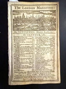
Sold20221762 London Magazine Attack on Havana and St. JohnsTitle: 1762 London Magazine Attack on Havana and St. Johns Description: The October 1762 issue of "The London Magazine", printed for R. Baldwin, 56 pages. Great content on military assault on Havana,See Sold Price
Sold20211762 Map of the Siege of HavanaAuthor: Kitchin Title: 1762 Map of the Siege of Havana Materials: Ink on Paper Dimensions: 7"X4.5" Description: Map of the siege of Havana and the Moor Castle dated 1762. Engraved and published by ThoSee Sold Price
Sold20231762 Magazine Plan of Havana Map of PortugalThe August 1762 issue of "Gentleman's Magazine" by Sylvanus Urban, printed at London, 48 pages and includes two engravings: A Plan of the City and Harbour of Havana and a large folding map of the KingSee Sold Price
Sold2018London Magazine: Antique Map of Havana, Cuba, 1762Title/Content of Map: A Plan of the City and Harbor of Havanna Capital of the Island of Cuba Cartographer: London Magazine Place & Date: London / 1762 Size: 4 1/2" x 7" Condition: wash color; overallSee Sold Price
Sold2022A Plan of the Siege of the Havana… Cuba. Gentleman's Magazine 1762 old mapTITLE/CONTENT OF MAP: 'A Plan of the Siege of the Havana Drawn by an Officer on the Spot 1762' DATE PRINTED: 1762 IMAGE SIZE: Approx 19.0 x 26.0cm, 7.5 x 10.25 inches (Medium); Please note that this iSee Sold Price
Sold2018Mondhare: Seven Years’ War British Siege of HavanaVue de la Prise des Forts et Ville de Havane par les Anglois en 1762 A dramatic view of the British siege of the forts and city of Havana, with lighters carrying troops who are about to scale the fortSee Sold Price
Sold2022ANTIQUE ETCHING PLAN OF NAVAL ATTACK WAR OF 1812Color etching representing a commented map of a naval attack. Titled Plan of the Attack Made by the British Barges on Five American Gunboats on the 14th December 1814 by Major A. LaCarriere Latour, PrSee Sold Price
Sold20201762 George Anson VOYAGE Round the World MAPS Spain1762 George Anson VOYAGE Round the World MAPS Spain South America Brazil Peru George Anson was an 18th-century British Navy admiral who is noted for his important world voyage in which he circumnavigaSee Sold Price
Sold2018Depot de la Marine: Havana Plan with Landmarks KeyReserve Reduced! Title of Map: Carte Hydrographique de la Baye de la Havane. Cartographer: Bellin / Depot de la Marine Place / Date: Paris / 1762/1772 Size: 22 1/4" x 16 1/4" Condition: wash color; ovSee Sold Price
Sold2024Revolutionary Era War Map of the Attack on Ft. Moultrie.Original 18th C hand colored map dated June 28th 1776 appears to be a fold out from a publication of the situation and stations of the British Vessels under the command of Sir Peter Parker upon the atSee Sold Price
Sold2018Bellin: Hydrographic Chart of Havana BayMap: Carte Hydrographique de la Baye de la Havane. Cartographer: Bellin / Depot de la Marine Place & Date: Paris / 1762/1772 Size: 22 1/4" x 16 1/4" Condition: b&w; some nicks, splits and fraying alonSee Sold Price
2022George Keppel, 3rd Earl of Albemarle. 1762 Capture of Havana, Cuba 1762 printTITLE/CONTENT OF MAP: [Portrait of] The Right Hon.ble George Earl of Albemarle Lieutenant General and Commander in Chief of the Land Forces, at the Conquest of the Havannah DATE PRINTED: 1762 IMAGE SISee Sold Price
Sold2023[MAP] BRITISH / FRENCH SETTLEMENTS NORTH AMERICALodge, John. A MAP OF THE BRITISH AND FRENCH SETTLEMENTS IN NORTH AMERICA. London: circa 1750s. Handcoloured. Floral cartouche. The present example includes text detail on the English settlement claimSee Sold Price
Sold20231763 Map British Governments in North AmericaEngraved folding map of "The British Governments in N(or)th. America Laid down and agreeable to the Proclamation of Oct. 7 1763.", Map of the colonies and other territories to Louisiana. Inset of BermSee Sold Price
Sold2021Tallis, John (Pub) 1852 Map. British America. CanadaSteel Engraved Map with Original Outline Hand Color Published 1852-56 by John Tallis, London for "The Universal Pronouncing Dictionary" by Thomas Wright. Drawn & Engraved by John Rapkin. Centre fold aSee Sold Price
Sold2021Wilkes, John 1797 Map. British Colonies in N. AmericaCopper Engraved Map Published 1796-1828 London for "Encyclopaedia Londinensis, or universal dictionary of arts, sciences and literature" by John Wilkes et al. Paper Size: 10.5 x 8.5 inch (27 x 22cm) VSee Sold Price
Sold2021Map, "British Possessions in North America"From Pinkerton's Modern Atlas, ca. 1810, published by Dobson, Philadelphia 21" x 28 3/4" sight size, 25 1/2" x 36" framed.See Sold Price
Sold2023[CANADIAN ANTIQUE MAP] BRITISH AMERICA. C.1850[CANADIAN ANTIQUE MAP] BRITISH AMERICA. Hand-coloured.Circa 1850sPublished by John Tallis, London and NY, 1850Frame size: (approx) 17.1/2"x21.1/2"Original Tallis map of British America (now Canada). VSee Sold Price
2 days LeftKinghams AuctioneersJohn Speed (British, 1552-1629), map of Buckingham (1610), coloured engraving, published by George£40
2 days LeftKinghams AuctioneersJohn Speed (British, 1552-1629), map of Herefordshire (1610), coloured engraving, published by John£40
2 days LeftKinghams AuctioneersJohn Speed (British, 1552-1629), map of Derbyshire (1610), coloured engraving, published by John£40
2 days LeftKinghams AuctioneersJohn Speed (British, 1552-1629), map of Dorsetshyre, coloured engraving, 38 by 51cm, framed.£40
Featured6 days LeftJasper521824 Cary Map of the British Isles -- Cary's Reduction of his Six Sheet Map of the British Isles;$320


![[MAP-CUBA] KITCHIN, THOMAS. Plan of the Havana and its Environs, with the several posts and attacks: [MAP-CUBA] KITCHIN, THOMAS. Plan of the Havana and its Environs, with the several posts and attacks made by the British Forces; under the command of the Earl of Albemarle and Sr. Geo. Pocock, which wa](https://p1.liveauctioneers.com/292/250642/130213656_1_x.jpg?height=310&quality=70&version=1654271664)


![George Keppel, 3rd Earl of Albemarle. 1762 Capture of Havana, Cuba 1762 print: TITLE/CONTENT OF MAP: [Portrait of] The Right Hon.ble George Earl of Albemarle Lieutenant General and Commander in Chief of the Land Forces, at the Conquest of the Havannah DATE PRINTED: 1762 IMAGE SI](https://p1.liveauctioneers.com/5584/271521/142285114_1_x.jpg?height=310&quality=70&version=1670968215)
![[MAP] BRITISH / FRENCH SETTLEMENTS NORTH AMERICA: Lodge, John. A MAP OF THE BRITISH AND FRENCH SETTLEMENTS IN NORTH AMERICA. London: circa 1750s. Handcoloured. Floral cartouche. The present example includes text detail on the English settlement claim](https://p1.liveauctioneers.com/8124/310027/165853621_1_x.jpg?height=310&quality=70&version=1700184289)


![[CANADIAN ANTIQUE MAP] BRITISH AMERICA. C.1850: [CANADIAN ANTIQUE MAP] BRITISH AMERICA. Hand-coloured.Circa 1850sPublished by John Tallis, London and NY, 1850Frame size: (approx) 17.1/2"x21.1/2"Original Tallis map of British America (now Canada). V](https://p1.liveauctioneers.com/8321/286473/155235081_1_x.jpg?height=310&quality=70&version=1686868575)


