Sold2019[Map] The State of North CarolinaLewis, Samuel. "The State of North Carolina from the best Authorities, &c." [Philadelphia: Mathew Carey, ca. 1795 or shortly after.] On heavy laid. Measured from plate-marks 49 x 29.5cm. Quite clean,See Sold Price
Sold20231795 J. Denison & A. Doolittle Maryland/Delaware Map1795 J. Denison & A. Doolittle Maryland/Delaware Map of the States Maryland And Delaware by J. Denison. 7 1/2 x 10 in acid free matt.See Sold Price
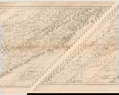
Sold2019State of New YorkTitle: State of New York Publication Date: 1809 Cartographer: LEWIS, SAMUEL Publisher: MATHEW CAREY Size: 16.1Height - 20.6Width compiled from the best authorities. 1809… Interesting early state mapSee Sold Price
Sold20241795 Map of the Southern States of AmericaRUSSELL, John C. (ca 1750-1829) Map of the Southern States of America, Comprehending Maryland, Virginia, Kentucky, Territory Sth. of the Ohio, North Carolina, Tennessee Government. South Carolina, & GSee Sold Price
2023MAP OF MARYLAND AND DELAWARE BY JOHN REID.Engraved map on laid paper, published by John Reid, New York. "The States of Maryland and Delaware, from the Latest Surveys, 1795" with Chesapeake Bay in the middle. Stains, minor creases, glued down.See Sold Price
Sold2018Antique Map - The Province of Maine c. 1795-96The Province of Maine, from the Best Authorities by Samuel Lewis , 1794; Copper engraving 1795-96, Engraved for Carey's American Edition of Guthries Geography improved; measures about 16 inches by 20See Sold Price
Sold20231795 Map, Maryland & Delaware [18th c. Cartography]Engraved map of Maryland and Delaware printed in 1799, based on a 1795 edition produced by Samuel Lewis. Drawn by A. Anderson, engraved by J. Scoles. Includes an inset map of the Continuation of the PSee Sold Price
Sold20191795 Carey Map of Maine -- The Province of Maine, FromReserve Reduced! Map Title/Content: 1795 Carey Map of Maine -- The Province of Maine, From the best Authorities by Samuel Lewis, 1794 Cartographer: M Carey Year / Place: 1795, Philadelphia Map DimensiSee Sold Price
Sold2021Framed Map of the States Maryland & Delaware from 1790Engraving by A. Doolittle, Published by Thomas & Andrews. From "The American Universal Geography" 3D 10"H x 8 1/4"WSee Sold Price
Sold2022Antique Map Print - America - Map of Baltimore - Maryland - United States - 1924Title: Antique Map Print - America - Map of Baltimore - Maryland - United States - 1924 Date/Period: 1924 Dimension: 38 cm x 27 cm Material: Paper Additional Information: This is an antique map of BalSee Sold Price
Sold2023Maps of Maryland and Washington State 1865Map of Maryland and Map of Washington State, 1865, smallest 7.75 x 10.5 inches, largest 9 x 12 inches, both unframed.See Sold Price
Sold2024Carey, pub. 1796 - Map of the State of MarylandThis fine map engraving is from one of the ealiest American atlases published in the states: Mathew Carey's General Atlas. The work was published in Philadelphia by Carey in 1796. It was an importantSee Sold Price
Sold2017Map of the States of Maryland & DelawareCirca 1796 Antique Map, Title: "Map of the States of Maryland and Delaware". Citation: by J. Denison. Amos Doolittle, Sculp. Approximate size: 10-5/8" x 8-3/8". Please note that this lot has a confideSee Sold Price
Sold2019[Map] The State of South Carolina 1796Tanner, Benjamin. "The State of South Carolina: from the best Authorities." New York: John Reid, [ca. 1796.] On heavy laid. Measuring from neat-lines 17" x 15". Lower edge remargined, mild toning, oneSee Sold Price
Sold20201795 Brookes Map of England and Wales -- A Map ofTitle: 1795 Brookes Map of England and Wales -- A Map of England and Wales Divided into Counties from the Best Authorities Year/Place: 1795 c. London Cartographer: Brookes Gazetter Size: 7.5 x 11 in.See Sold Price
Sold2016Large 1862 US Civil War Wall MapColton's Map of the Southern States. Including Maryland, Delaware, Virginia, Kentucky, Tennessee, Missouri, North Carolina, South Carolina, Georgia, Alabama, Mississippi, Arkansas, Louisiana, Texas ..See Sold Price
Sold2024Large Map of The State of Florida by Bruff (Washington D.C., 1846)Large Map of The State of Florida by Bruff (Washington D.C., 1846) "The State of Florida Compiled in the Bureau of Topographical Engineers from the Best Authorities," engraved two-sheet map drawn by JSee Sold Price
Sold2018Benjamin Warner Map of United States Philadelphia, 1820Benjamin Warner's map of the United States of America corrected and improved from the best authorities, 1820. Published by B.Warner, Philadelphia. Dimensions: Framed: 21 inches x 28.5 inches, Sight: 1See Sold Price
Sold2016Antique Middle States Map - 1872Antique Middle States Map - 1872, featuring Maryland, Virginia, West Virginia, Pennsylvania, New York & New Jersey. Size : 9" x 10.75"See Sold Price
Sold20231862 Civil War, Coltons New Topographical Map of The States of Virginia, Maryland and DelawareHistoric Maps 1862 Civil War "Colton's New Topographical Map of The States of Virginia, Maryland and Delaware" Hardcover Folio 1862-Dated Civil War Period, Hand-colored 45.25" x 31.5" Folding Map titlSee Sold Price
Sold2023VINTAGE STATE MAPS / TRAVEL EPHEMERA, UNCOUNTED LOTVINTAGE STATE MAPS / TRAVEL EPHEMERA, UNCOUNTED LOT,for states Maine, Maryland including Baltimore, Massachusetts including Boston, and Michigan, with Shell and Conoco examples.20th century. ProvenancSee Sold Price
Sold2021County Map of the States of Delaware, Maryland,Publication Date: c1887 Title: County Map of the States of Delaware, Maryland, Virginia And West Virginia Cartographer: BRADLEY Publisher: BRADLEY & COMPANY Good atlas map with two small insets. On reSee Sold Price
Sold2018County Map of the States of Delaware, Maryland,Reserve Reduced! Title: County Map of the States of Delaware, Maryland, Virginia And West Virginia Publication Date: 1886 Cartographer: MITCHELL, S. AUGUSTUS, JR. Publisher: BRADLEY & BRO. Size: 14.5See Sold Price
Sold20211825 Carte Geographique, Statistique et Historique DuBy: Jean Alexandre BuchonDate: 1825 (Published) ParisDimensions: 18.5 x 25 inches (47 cm x 64 cm)This antique map is a rare example by Buchon depicting the state of Maryland by itself, rather than togSee Sold Price
2 days LeftBrunk AuctionsGeorgian Tortoiseshell Veneered and Mother of Pearl Inlaid Tea Caddy$600(2 bids)
2 days LeftJasper52A New and accurate Map of New Jersey… Universal Magazine 1780 old antique$650
17 hrs LeftJasper521801 Cary Map of Austria -- A New Map of the Circle of Austria from the Best Authorities$95
2 days LeftJasper52An Accurate Map of the County of Kent Divided into its Lathes… by E Bowen 1762$320
2 days LeftJasper52A New and accurate Map of Connecticut and Rhode Island… Universal Magazine 1780$500
4 days LeftTrillium Antique Prints & Rare BooksDe L'Isle - Map of Louisiana and the Course of the Mississippi (Eastern America) (First Appearance$240(2 bids)
Oct 12JM Hobby Supply and Railroad Artifact AuctionsWest Virginia Central and Pittsburg Railway Annual Report-1882$30(1 bid)
2 days LeftLeland LittleRobert de Vaugondy's 18th-Century French Map of North America's Eastern Seaboard$50
Oct 18Rail & Road Auctions1878 Maps of the New and Popular St. Louis and Texas Short Line Railroad Color Lithograph$40(1 bid)


![[Map] The State of North Carolina: Lewis, Samuel. "The State of North Carolina from the best Authorities, &c." [Philadelphia: Mathew Carey, ca. 1795 or shortly after.] On heavy laid. Measured from plate-marks 49 x 29.5cm. Quite clean,](https://p1.liveauctioneers.com/3532/146911/74242522_1_x.jpg?height=310&quality=70&version=1564368564)


![1795 Map, Maryland & Delaware [18th c. Cartography]: Engraved map of Maryland and Delaware printed in 1799, based on a 1795 edition produced by Samuel Lewis. Drawn by A. Anderson, engraved by J. Scoles. Includes an inset map of the Continuation of the P](https://p1.liveauctioneers.com/7226/275519/144720286_1_x.jpg?height=310&quality=70&version=1673742614)


![[Map] The State of South Carolina 1796: Tanner, Benjamin. "The State of South Carolina: from the best Authorities." New York: John Reid, [ca. 1796.] On heavy laid. Measuring from neat-lines 17" x 15". Lower edge remargined, mild toning, one](https://p1.liveauctioneers.com/3532/146911/74242458_1_x.jpg?height=310&quality=70&version=1564368564)


![[CIVIL WAR] Maryland Belt Plate (1 of 2)](https://p1.liveauctioneers.com/7226/343781/186766750_1_x.jpg?height=282&quality=70&version=1726946482)


![[COLONIAL AMERICA] 1725 Baltimore Co. Maryland Land Grant (1 of 2)](https://p1.liveauctioneers.com/7226/343781/186766609_1_x.jpg?height=282&quality=70&version=1726333566)


